
 |
| Academic Departments | Student Services | Alumni | Research | Outreach | Diversity |
| 1 | 2 | 3 | 4 | 5 | 6 | |
| 7 | 8 | 9 | 10 | 11 | 12 | 13 |
| 14 | 15 | 16 | 17 | 18 | 19 | 20 |
| 21 | 22 | 23 | 24 | 25 | 26 | 27 |
| 28 | 29 | 30 | 31 |
| 1 | 2 | 3 | ||||
| 4 | 5 | 6 | 7 | 8 | 9 | 10 |
| 11 | 12 | 13 | 14 | 15 | 16 | 17 |
| 18 | 19 | 20 | 21 | 22 | 23 | 24 |
| 25 | 26 | 27 | 28 | 29 | 30 |
Daily Journals
June 4, 2006 - Tickle Pass
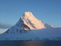
It’s around 10am, and if I squint, I can tell we’re in a really pretty place. It is cloudy and drizzling rain. But I can see to the land’s edge on either side of the ship, and know that we’re in a narrow passage of some sort. Lots of chunk ice, bergie bits and growlers are packing in with that NE wind. There are big icebergs, too, but where are we? Up to the Bridge with me! From the charts and our GPS location, I can see we have come through the Barlas Channel, The Gullett, and are now in the Tickle Channel. The Captain tells me that collectively we are in what is called “Tickle Pass”. We are technically between Adelaide Island (L) and Hansen Island (R) when we’re in the Tickle Channel, then it opens out to Arrowsmith Peninsula and the Continent on our right. We’re heading north and will tonight pass Laird Island to starboard, and out into the Matha Strait. Around midnight we will cross the Antarctic Circle line again. As the day progressed and the weather cleared (what a gift!!), everyone was out on deck with their cameras. As the clouds lifted they first lingered and blanketed the mountain peaks in pink and white cotton, but gave way to a very nice view and a pretty sun-day. The largest of the relatively nearby peaks (at ~6,300 ft Charcot saw it first, in 1909) was Mount Reeves on Adelaide Island, and as the clouds gave way and the sun rose enough to shine on it, we could see - it was enormous!! There were large icebergs, and Antarctica rock rising straight out of the water on all sides. What a day for taking photos! And we need days like this, at least every few what a lift, what a life it is this kind of day that really lays it out for you “I am in some place very special”.
Getting to Know You Tracing Our Path (or, Where did “Tickle Pass” get its name?) We are heading north from Marguerite Bay… Barlas Channel is in the northern part of the Laubeuf Fjord, southwest of The Gullet. It separates Adelaide I. and Day I. The FIDS named it for William Barlas, the British representative at Deception Island and the South Shetland Islands for the season 1914-1915, and also at South Georgia at various times. (Wow. He gets a whole Channel named for him just for this?? Rudi’s been here and has actually done something, five times!!!) The Gullet is a narrow channel between Adelaide I. and the west coast of Graham Land. It separates Hansen and Day Islands, and connects the heads of Hanusse Bay and the Laubeuf Fjord. It was first explored by Charcot, and was named by the FIDS. (When the tide is running just right, it makes a sound like, “chug-a-lug, chug-a-lug”.) Tickle Channel is the southern part of Hanusse Bay. It is 1-3 miles wide and 5 miles long going north from The Gullet. It separates Hansen I. from Adelaide I. It was named by the FIDS. In Newfoundland and Labrador, a ‘tickle’ is a narrow passage between two islands. (The ride through it makes you want to put your hands in the air and yell “Wheeeeeeeeeeeeeeeeee!!!”) Hanusse Bay is a broad bay about 20 miles long running north-south between Adelaide I. and the Arrowsmith Peninsula on the Continent. It was discovered by our old friend Jean-Baptiste Charcot, and named by him for the Director of the Hydrographic Service in the French Navy. (I’m telling you, this guy banked some serious favors…) Graham Land: As per the 1964 agreement between the US and UK in which “Antarctic Peninsula” was the approved term for the major peninsula, and the names “Graham Land” and “Palmer Land” would be used for the northern and southern portions, respectively. It was named after Briscoe’s exploration in 1932, for Sir James R. G. Graham, the First Lord of the Admiralty. (Who also thought the mountains reminded him of large brown crackers.) And so, all together this collection of waterways and its surroundings is called, (she giggles) “Tickle Pass”.
Back to the Science The benthic tow rocks have yielded perhaps a treasure after all. Some tiny brachiopods (look like delicate limpets the size of a small child’s fingernail) were scraped from the surface of one of the rocks, scrutinized under the microscope, photographed liberally and it is believed this particular critter has not formerly been described in literature. They are quite beautiful in detail. There is more, about those baby corals Rhian Waller is ‘raising’, so that’s fodder for a Journal soon to follow. Cpt. Marty Galster said he had never seen so little ice in Marguerite Bay at this time of year as we did both going down and coming back. For whatever reason (‘global warming?’ is the question in everyone’s mind), we were fortunate, because it was that lack of ice that enabled us to travel so far south this trip. And the further south we sample, the more we know about those waters and the life and changes in them.
Don't hesitate to email questions to us at outreach@lmg.usap.gov
|
Longitude/Latitude: S67° 09.822’ W67° 38.717’ Temperature: Wind: NE 10-13kn Wind Chill: -11.0°C (felt colder!) Weather: Rainy and overcast
Menu: Lamb chops, baked chicken, green beans, mac & cheese, soup, salad; Veg. Lasagna, braised steak, green beans, penciltip rice, salad, flan, frosted brownies, pecan pie and cookies.
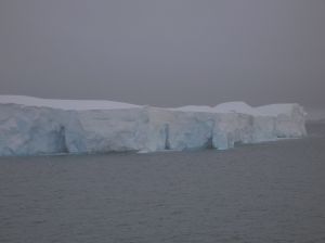
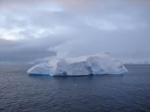
Photos: First shot from the Bridge on an overcast morning. The big berg. Photo by Ellen Bailey
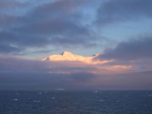
Sunrise from out behind the cottony clouds around 1030. [Photo by E. Bailey]
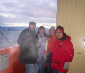
Andy Mahon, Alexis Janosik, Nerida Wilson and Chris Mah in
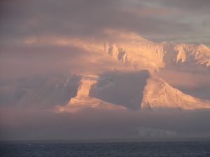
Mt. Reeves in ‘Tickle Pass’. [Photo by E. Bailey]
Mt. Reeves just didn’t stop giving us a show. Large iceberg in haze in foreground. [Photo by Janis Umschlag]
Iceberg in Tickle Pass. [Photo by Janis Umschlag]
A ‘peek’ at a small island in Tickle Pass. [Photo by Diego Gilberto] |


- Alabama Agricultural Experiment Station
- Alabama Cooperative Extension System
- Auburn Online Community
- Bookstore
- Center for Diversity
- Crisis/Incident Assistance
- Diversity and Multicultural Affairs
- Financial Aid
- Hotel and Conference Center
- Jule Collins Smith Museum of Fine Art
- Medical Clinic
- Southeastern Raptor Center
- Special Reports
- Students w/ Disabilities
- Theatre