
 |
| Academic Departments | Student Services | Alumni | Research | Outreach | Diversity |
| 1 | 2 | 3 | 4 | 5 | 6 | |
| 7 | 8 | 9 | 10 | 11 | 12 | 13 |
| 14 | 15 | 16 | 17 | 18 | 19 | 20 |
| 21 | 22 | 23 | 24 | 25 | 26 | 27 |
| 28 | 29 | 30 | 31 |
| 1 | 2 | 3 | ||||
| 4 | 5 | 6 | 7 | 8 | 9 | 10 |
| 11 | 12 | 13 | 14 | 15 | 16 | 17 |
| 18 | 19 | 20 | 21 | 22 | 23 | 24 |
| 25 | 26 | 27 | 28 | 29 | 30 |
Daily Journals
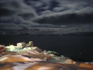
June 13, 2006 - The Straits of Magellan (Estrecho de Magallanes)
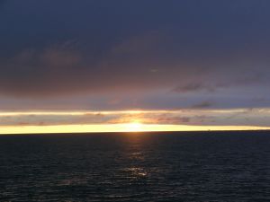
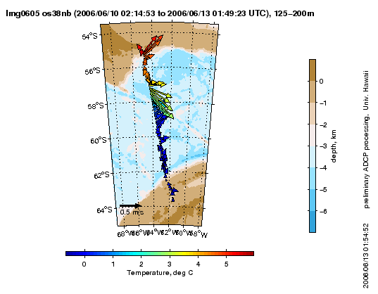
We’ve traveled through the Estrecho de la Maire between Tierra Del Fuego and Isla de los Estados (Arg.) and up a long 180 mile stretch of the eastern coast of Argentina to reach the Estrecho de Magallanes the Strait of Magellan. We will travel some of the distance on our own, and then the Pilot Boat will come to us to deliver a pilot who will steer the ship the rest of the way to Punta Arenas, about a ten hour trip. We plan to arrive in PA at 0800. It’s as calm as can be, and except for the engine drone, you’d not really know you were on board a ship. Wait until I step off onto the pier and walk around before I say that every heard of “dock rock”? That’s when you get off the ship, and feel like you’re still on a ship for a long time. I remember last trip, I felt it for about a week. I wish I’d kept a record of how many one-handed showers were necessary on this trip, now that I’m completely spoiled about not needing to hang on all the time. It’s been a few days since that was necessary, and for that I am eternally grateful. (I know, what a whuss. “And she calls herself a sailor!”) Along the way, the sun was silver behind a bank of very interesting layers of clouds, and shone silver on the waters of the Strait. It spit rain most of the day even in that silver light, and as the sun sank below the clouds and shone golden for a radiant sunset, it delivered us a full rainbow - no, a double rainbow with the most brilliant colors I’d ever seen! We were like ants between hills, running back and forth on the ship to see the sunset off the bow, the rainbows off the stern. Yesterday I had a whirlwind lesson on the sextant, and today I have a little extra free time, so I thought I’d tackle quantum physics. I won’t be writing about that, however. Instead, I’ll have Max Nikurashin help me describe his results from deploying hundreds of XBT’s, about 70 of them in the Drake Passage for this diagram. A section of profiles is useful to know when the ship has crossed a front and, in our case, when the scientists can expect to find different animals in the water. In this illustration,the section is arranged as though you are looking from the Atlantic into the Pacific with Antarctica to the left. We are looking for the Polar Front, where the warmer waters of the north meet the colder waters of the south. Warmer water to the right (north) is less dense and would be expected to float slightly higher, even on top of, the colder water to the left (south). But the rotation of the earth in the southern hemisphere causes this southward flow to ‘turn left’ and the warm water meeting the cold water creates a vertical Front. From the section you can also see that the coldest water, around 0°Celsius, is at the surface. It is expected to be dense because of its lower temperature and should therefore sink, but because it doesn’t, then it must be less salty than the warmer water beneath it. One cause of this might be, this is early winter in Antarctica and some ice melt from the summer and fall could have made the cold water slightly more fresh, to produce this cold layer of water. Another thing we see in this diagram is the donut-shaped (although ‘pointy’) ring of yellow 5°C water surrounded by colder water, then the start of warmer (7°C) water as we reached the end of the Drake Passage near South America. That yellow ‘ring’ is one of those ‘eddies’ Rudi Scheltema referred to in his theory about warmer water patches sort of breaking off from the swirl of the current, taking with it floating plankton and working its way across the current of the Drake. This is how Rudi explains the possible occurrence of the same species of animal (both planktonic and benthic) on both sides of the Drake Passage when normally the power of the water’s current would suggest northern and southern species would be cut off from one another. This diagram (ADCP chart at right) shows the vectors of the surface currents running through the Drake Passage. The arrows or ‘vectors’ indicate the direction (as direction) and magnitude (as length) of the currents, and their colors represent the temperatures measured by the XBTs. You will see that a cluster of long vectors occurs just at the point (latitude) where, on the first graph, the Antarctic Polar Front occurs. It is expected to see a strong current where there is a rapid change in water temperature. Voilá. Back to quantum physics.
Getting To Know You
Back to the Science - 3 After Dinner Talks Alex Eaves
Rhian Waller
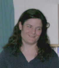
Susie Balser It is always a pleasure to see Susie’s microscope photography displayed and described. Susie gave a summary of the many sights and science she encountered while on this cruise, as well as shared some of her many questions that these observations raised. The images were immaculate, and Susie’s humor and enthusiasm made the lessons feel like, well, entertainment that was somewhat cerebral. It was a coffee table book, only animated!
|
Longitude/Latitude: S52° 59.460’ W67° 37.147’ Temperature: Wind: WSW 2-3kn Wind Chill: 6°C
Menu: Roast turkey, baked ham, peas ‘n carrots, mac ‘n cheese, rice, soup, rolls, salad sans lettuce; Veg lasagna, spaghetti & meatballs, carrots, bread, choc cake, bread pudding, ice cream and cookies.
Photos:
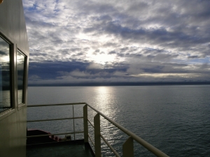
To every cloud, …. Strait of Magellan [Photo by E. Bailey]
Woe is me, I can’t do it justice!! The left one was a full bow. [Photo by E. Bailey]
The last ocean sunset for us aboard the LMG. [Photo by E. Bailey]
ADCP chart
Alex Eaves
Rhian Waller
Susie Balser [Photo by Steve Alexander]
Would you like to take a walk down Memory Lane? [Photo by Morris Cohen]
…. And more special moments. [Photo by Steve Alexander]
Something special from Palmer Station. [Photo by Morris Cohen]
Still missing Home??? (Of course you are.) [Photo by Morris Cohen]
|


- Alabama Agricultural Experiment Station
- Alabama Cooperative Extension System
- Auburn Online Community
- Bookstore
- Center for Diversity
- Crisis/Incident Assistance
- Diversity and Multicultural Affairs
- Financial Aid
- Hotel and Conference Center
- Jule Collins Smith Museum of Fine Art
- Medical Clinic
- Southeastern Raptor Center
- Special Reports
- Students w/ Disabilities
- Theatre