
 |
| Academic Departments | Student Services | Alumni | Research | Outreach | Diversity |
| 1 | 2 | 3 | 4 | 5 | 6 | |
| 7 | 8 | 9 | 10 | 11 | 12 | 13 |
| 14 | 15 | 16 | 17 | 18 | 19 | 20 |
| 21 | 22 | 23 | 24 | 25 | 26 | 27 |
| 28 | 29 | 30 | 31 |
| 1 | 2 | 3 | ||||
| 4 | 5 | 6 | 7 | 8 | 9 | 10 |
| 11 | 12 | 13 | 14 | 15 | 16 | 17 |
| 18 | 19 | 20 | 21 | 22 | 23 | 24 |
| 25 | 26 | 27 | 28 | 29 | 30 |
Daily Journals
May 18, 2006
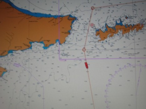
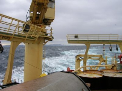
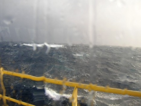
By dawn, we were steaming through the channel that separates the southern tip of South America (Argentine side of Tierra del Fuego) and Staten Island (Isla de los Estados). This route Estrecho de le Maire, although still quite open ocean we can see land on both sides, but the channel is about 15 kilometers wide gives us some leeward protection and somewhat calmer seas. We are in Argentine waters, and so the flag of Argentina is highest on our mainmast. (Do you know whose flag flies highest when we get close to Antarctica?) [Insert Photo 1] Today begins a series of XBT drops as we cross the Drake. In a regular, timed pattern, a measuring device called an XBT (expendable bathythermograph) is being used to measure the temperature of the water through the water column (top to bottom). From my Journal writings of a previous trip south, I will use the explanation given by WHOI scientist/engineer Sandy Williams: The weather prevents this from being very long today. The decks are closed off due to wind and waves, but through the windows, the ocean is awesome!! Waves at minimum 18-20 feet with an occasional 2 or 3 much bigger, and 40 knot winds gusting to 70. It’s so big, it all looks like slow motion. And the ship lifts up, tips one way, then the other, and goes back down again it’s all we can do just to keep chairs and other things from moving, so we’re being very diligent about tying down all of the equipment in the labs. I’m sorry to say the plankton lab lost a can of Pringles to the mighty forces of the sea but otherwise all is well. No science today, except for the XBT’s (since they’re mostly automatic). People do have to go out occasionally to reload the launcher, with due caution.
So, don't hesitate to email questions to us at outreach@lmg.usap.gov
|
Longitude/Latitude: 11:30 am: S55° 06.939’ W64° 57.335’ 4:30 pm:
S55° 47.612’ W64° 43.508’ Temperature: 11:30 am: Wind: 22kn 4:30 pm: Wind: 47.9kn (gusting to 60)
Menu: Chicken parmesan, veg lasagna, spaghetti & meatballs, br. sprouts, broccoli, garlic bread, fruit, salad, cake and cookies. I’m not coming back to tell you what’s for dinner
Photos:
Last sight of land, Tierra del Fuego, as we enter the Drake Passage
A still photo from the Bridge just doesn’t tell the story |

- Alabama Agricultural Experiment Station
- Alabama Cooperative Extension System
- Auburn Online Community
- Bookstore
- Center for Diversity
- Crisis/Incident Assistance
- Diversity and Multicultural Affairs
- Financial Aid
- Hotel and Conference Center
- Jule Collins Smith Museum of Fine Art
- Medical Clinic
- Southeastern Raptor Center
- Special Reports
- Students w/ Disabilities
- Theatre