
 |
| Academic Departments | Student Services | Alumni | Research | Outreach | Diversity |
| 1 | 2 | 3 | 4 | 5 | 6 | |
| 7 | 8 | 9 | 10 | 11 | 12 | 13 |
| 14 | 15 | 16 | 17 | 18 | 19 | 20 |
| 21 | 22 | 23 | 24 | 25 | 26 | 27 |
| 28 | 29 | 30 | 31 |
| 1 | 2 | 3 | ||||
| 4 | 5 | 6 | 7 | 8 | 9 | 10 |
| 11 | 12 | 13 | 14 | 15 | 16 | 17 |
| 18 | 19 | 20 | 21 | 22 | 23 | 24 |
| 25 | 26 | 27 | 28 | 29 | 30 |
Daily Journals
May 26, 2006
Got the phone call around 10 a.m. to announce we’d be at Deception Island
in an hour. Not so much that I should be sleeping in, but it was a rocking
kind of night (no rolling but I haven’t mastered the head-to-foot motion
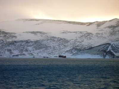
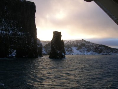
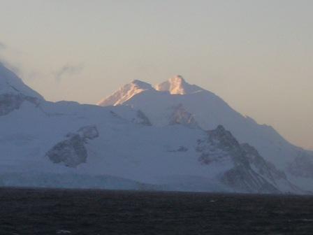
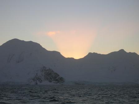
yet). Besides, I knew there would be no a.m. operations, since the last It was a clear, cold and windy day, but there were no atmospheric hindrances to the grand view of Neptune’s Bellows, the entryway to the harbor within the caldera, Port Foster. Deception “Island” is actually a sunken volcano, a small opening in the wall of which made way for the ocean to enter and fill that caldera making it a mighty welcome port for whalers, sealers, adventurers, scientists and now, yes, even tourists. There’s no real shelter on land any more, but there are several structures left behind from days gone by, artifacts of the industries and professions that long preceded this traveler. There are outbuildings, living quarters, an airplane hangar, huge oil tanks, wooden boat frames, an old tractor covered with lava rock up to its steering wheel all abandoned, rusted or weatherbeaten now, but left to remind us of at least one place in these forbidding surroundings where humans had walked and attempted to tame the land to make a living, or in the realm of science, to make a difference. The last time this volcano erupted was in 1967, and that marked the departure of the last homesteaders, a UK science station team. The Deception Island stop was just eye candy for now, no going ashore. But
the light was just beautiful, the sun never clearing the landscape, but
leaving just a glint of gold on the snowy peaks. It is really, really cold
out there (wind-driven), and our shutter fingers were put to the
test. ‘Crab traps’ were readied on the main deck for a later sampling
plan, and that could not be done at sea, so we’ve just ducked in for the
calm waters. At 4 p.m. we had steamed 10 miles northeast to a bay in McFarlane Strait, between Livingston and Greenwich Islands which will be the next science stop. There’s a high pressure area in our midst, and the weather looks clear for the next couple of days. Getting to Know You - The Beaufort Scale Don't hesitate to email questions to us at outreach@lmg.usap.gov
|
Longitude/Latitude: S63° 18.88’ W59° 53.20’ Deception Island - A Quick Stop Only Temperature: Wind: SSE 20-25kn Wind Chill: -22°C Menu: Beef pasties, chicken cordon bleu, broccoli, cauliflower,
Photos:
Whaler’s Bay from Port Foster (the harbor inside the caldera) [Photo by Ellen Bailey]
‘Neptune’s Bellows’, looking back out from the harbor entrance]
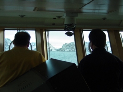
Jen Putland, Trevor Rafferty and Rhian Waller (foreground) brave the cold to see a beautiful sight, Deception Island] [Photo by Ellen Bailey]
Sun’s glow on snowy peaks. So…. Club Med would be around that other side??] [Photo by Ellen Bailey]
Sun’s glow from behind peaks of Livingston Island. Day is done.] |

- Alabama Agricultural Experiment Station
- Alabama Cooperative Extension System
- Auburn Online Community
- Bookstore
- Center for Diversity
- Crisis/Incident Assistance
- Diversity and Multicultural Affairs
- Financial Aid
- Hotel and Conference Center
- Jule Collins Smith Museum of Fine Art
- Medical Clinic
- Southeastern Raptor Center
- Special Reports
- Students w/ Disabilities
- Theatre