[Wind: WSW 20-24kn / Air Temp: -0.4C / Wind Chill: -16.5C /Depth: 488m]
Deception Island: Long/Lat: S062° 59.304 W060° 34.081 (noon)
| Home |
| Questions |
| Participants |
| Background Information |
At long last, winds and science considered, we were able to enter the bay of Deception Island around 0630 and have a bit of a recess from the normal routine.
| 1 | 2 | 3 | 4 | 5 | 6 | |
| 7 | 8 | 9 | 10 | 11 | 12 | 13 |
| 14 | 15 | 16 | 17 | 18 | 19 | 20 |
| 21 | 22 | 23 | 24 | 25 | 26 | 27 |
| 28 | 29 | 30 |
| 1 | 2 | 3 | 4 | |||
| 5 | 6 | 7 | 8 | 9 | 10 | 11 |
| 12 | 13 | 14 | 15 | 16 | 17 | 18 |
| 19 | 20 | 21 | 22 | 23 | 24 | 25 |
| 26 | 27 | 28 | 29 | 30 | 31 |
Ive posted the coordinates as to where it is, along the southern border of the South Shetland Islands.
You should probably Google it to learn about its interesting history, and how it came to earn its name. Deception Island is shaped like a doughnut with a large hole, and a small navigable opening on its southeast edge. Its topographical/geological shape is called a caldera which, especially for you Harry Potter fans, would liken it to a cauldron. It is actually the top of a volcano that has blown its top, and filled with ocean water. The entrance channel is really a small opening, with waters as shallow as 6 feet across most of it. The helmsman must navigate via GPS (satellite fix) to find the narrow deep passage on the northeast side of the opening for a ship this size to cross without hitting bottom (and theres something bad about that???).
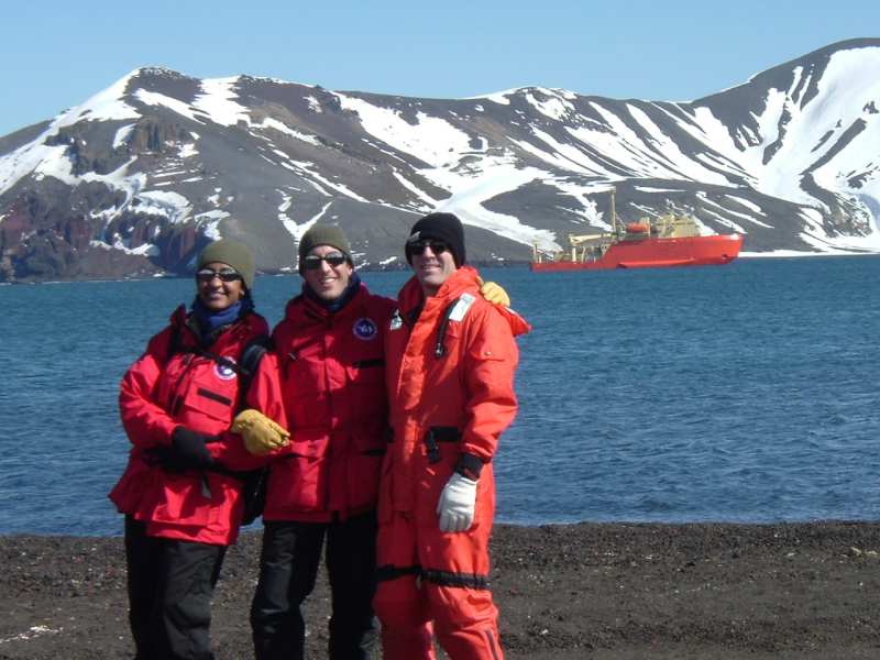
Before we went ashore, Skip Owen, the ships Marine Projects Coordinator (hes everywhere, a very big job), gave us a rundown on the areas we were allowed to explore, and those we could not (due to some of its being protected for either natural or geologic reasons), once ashore as well as in the bay. We were shuttled ashore a little after noon. The wind had calmed considerably, and although we were dressed for, well, the Antarctic, we were able to pare down a bit, especially with the hiking we were doing. Four layers was plenty. It was a crystal clear, sunny day and the entire area we could explore was easy to map out in its visible panorama. The cove where we landed in Whalers Bay was a few hundred yards deep, leading back to eroding, almost vertical walls of ragged brown rock, and the beach was maybe a mile long. From 1911 to 1931 Whalers Bay served as a haven where Norwegian whale ships brought their catch to process the carcasses along their lengthy excursions, and was later a British research station. There were four or five derelict buildings and rusted oil (whale oil?) tanks, abandoned now, but still standing watch as part of this remarkable landmark.
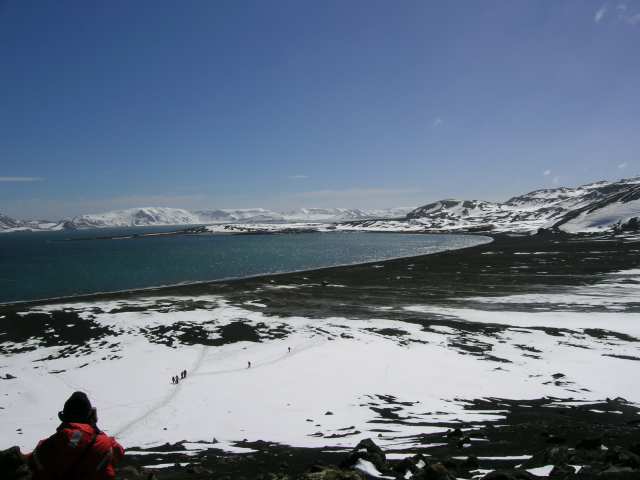
It is desolate land, made up mostly of dark brown/black gravel, and snow. The gravel is actually volcanic lava, widely distributed the last time the volcano really blew, in 1967. One hike on this soft ball bearing-like surface went to the right of our landing. It led to the end of the beach with a gradual uphill climb to Neptunes Window, a huge U-shaped hole in the caldera wall. There was no way of seeing what was up there from anywhere in the bay, so the surprise was our pleasure!! The back side of that window was a shear cliff, 120 feet straight down to the outside shoreline below. It was a beautiful little cove, with absolutely no access except perhaps to rappel down the wall. Steep, uneven and with lots of character, the waves moved in and out over the brown sand, leading your eye to the nooks and caves they had etched over the years. Every so often (how many waves apart are the big ones?), a large wave would break in a craggy nook, spray up about 20 feet and leave behind a brief but beautiful rainbow. Many people compared the view to those one might see in Hawaii (less the tropical flowers, but let your imagination fill that in or not! Its Antarctica!!). Way off in the distance, large icebergs floated, and even further than way, about 24 miles on this exceptionally clear day, we could see the snowcapped mountains of Livingston Island peaking through the mist. Ahhhhhhhhhhhhh.
Time was limited (we spent two hours on land), so we headed back to our landing point and then to the left of it, to explore the buildings. It was evident how the rain of cooling lava pellets had beaten those buildings, partially burying some of the structures. Along the way there were the remains of a tractor, with just the rusty and bent steering wheel and the tops of the metal tire treads above the gravel.
Some of the buildings were made of corrugated sheet metal, such as the airplane hangar. It seemed to be the best barrier to the elements here, but it has outlived its usefulness to humans. There are only few windows intact, and one side room, which probably served as an office or shop area, was filled with snow. The hangar bay gave me an eerie feeling, in its vast emptiness. You could just barely imagine working in there in the low-tech 1920s and hearing the howling winds drawing on its thin walls, resisting thoughts of a real home. What could any kind of life have been like here?
There were plaques with the chronological history of this settlement on a couple of the buildings. It was started in 1911, and through a series of use-and-abandonments, was finally left for good with the last big volcanic eruption in 1967. A bent and weather-beaten wood building had the remnants of one wall still attached to the roof, no longer protecting the coal room at ground level. Its bags of coal were all tattered, piles of the black fossils glinting in the midday sun. Every picture tells a story, but I couldnt make out the details of this one, so foreign is this lifestyle to me. (And this is another reason why this trip is so valuable.)
There are a couple of research stations further into the bay. We saw ones for Spain and Argentina, and saw an inflatable boat go into one, but try as we may, could not get them to answer a contact radio call. (Perhaps the Esperanza Station had warned them about us??)
We saw two types of penguins, chinstrap and Gentou, hanging out near the waters edge in twos and threes. They were not particularly fearful of us, and cooperated with the many photo-opportunists along the way.
The last bit of business on the shore wise part of the visit was for the divers to look for whale bones. Dr. Thomas Dahlgren has a special interest in the underwater worms that clean whalebones. They easily found a large scattering of bones in about 7 feet of clear water, and were able to dive down and take some video of them.
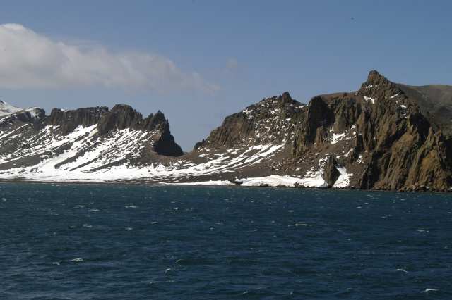
Photo3
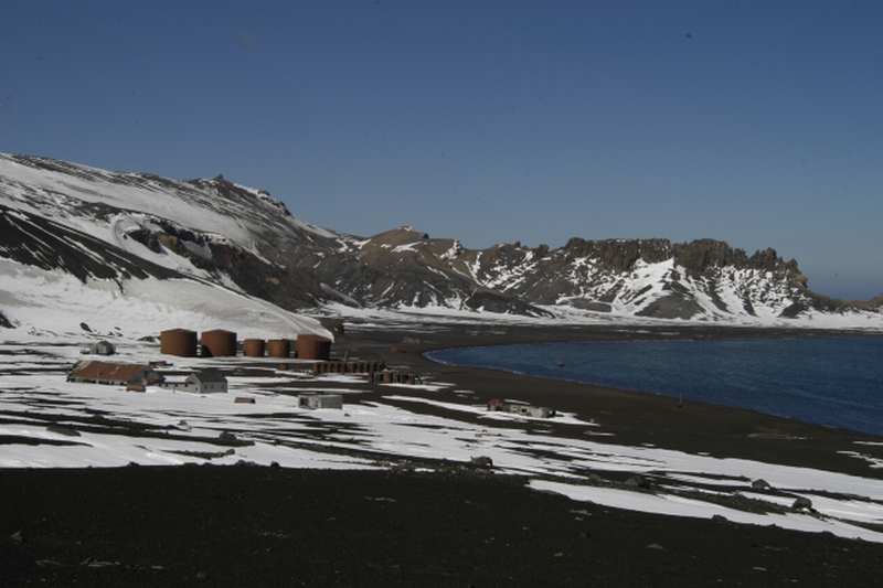
Photo4
We figure the bones were about 75 years old, and yet still there, taking their time to return to the sand as small grains of calcium amidst the lava pellets. One scoop of that sand would make an interesting time capsule story, dont you think? Plankton and benthic samples were drawn from the deeper waters here before we left. It had been one more special day with some landside exercise and macroscopic pleasures for all.
I cant remember what we had for dinner, sorry.
Dinner Menu (shipboard, 12/8): |
|
TBD |