| Home |
| Questions |
| Participants |
| Background Information |
Air Temp: 1.3C
Wind: 30k
Wind Chill: 15.1C
Water Depth: 565meters
4 swell
We have been performing scientific data collection around Elephant Island all day. It is very cold, windy, and a little snowy.
| 1 | 2 | 3 | 4 | 5 | 6 | |
| 7 | 8 | 9 | 10 | 11 | 12 | 13 |
| 14 | 15 | 16 | 17 | 18 | 19 | 20 |
| 21 | 22 | 23 | 24 | 25 | 26 | 27 |
| 28 | 29 | 30 |
| 1 | 2 | 3 | 4 | |||
| 5 | 6 | 7 | 8 | 9 | 10 | 11 |
| 12 | 13 | 14 | 15 | 16 | 17 | 18 |
| 19 | 20 | 21 | 22 | 23 | 24 | 25 |
| 26 | 27 | 28 | 29 | 30 | 31 |
Nothing sticks, however, because it is snowing sideways!
Lots of sampling activity today. We picked up some nice, clean plankton samples in the net, sent the benthic sled trawl out for bottom sampling, and the Tucker trawl for salps. An ROV (remotely operated vehicle) was even used today, and well get to see that recording, too. I understand it took some impressive footage of the ships propellers in the course of its trek!
Here are the changes in water depth as we traveled
from the Burdwood Bank to Elephant Island:
26 Nov. 101m
27 Nov. 139m
28 Nov. 410m
29 Nov. 2009 4292m (Wow! Thats deep!)
30 Nov. 4032m
01 Dec. 2346 > 436 > 105 > 565m
From this, you can perhaps make a mental map of the ocean floor we crossed, and see how we knew we were approaching land, even in the fog. That was quite an abyss in the middle, which is why we didnt do any benthic trawls there!
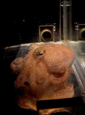
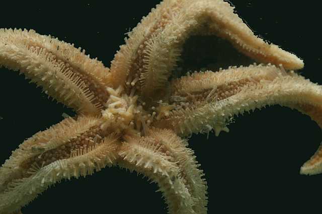
Catches of the Day: Octopus in benthic trawl, about 4 inches long, that inked when they took it out, making a mess of things (Aw You made me ink!), and a brooding starfish. Brooding means it was a mother starfish with babies under it. The starfish mother sits over her babies as they grow, never leaving even to feed, until they are big enough to venture out on their own. [Image 1 by Regina Campbell-Malone & Image 2 by Susie Balser]
Heres another activity for you. Youll need an Atlas-like map of the ocean area we just crossed (showing longitude and latitude), and a protractor, or a good ruler, or even a piece of string. Looking at the coordinates (Long/Lat) from the last 2 midnights, make dots on the map to represent our positions. Measure the distance from dot to dot, then holding that measurement, go to the gauge on the map and using that exact measure, you can see how many miles we traveled in that 24 hours. Sometimes we steam on through, but most days we stop or slow down to a crawl to put out some collecting gear.
We will be steaming now toward King George Island and the tip of the Antarctic Peninsula.
Theres a vcr/cd player in there, too, and I had some exercising companions and good Australian music to keep the rhythm going. For having done this, tomorrow I will likely need to use the Jacuzzi Ill tell you about that later.
Dinner Menu (shipboard, 12/1): |
|
TBD |