
GEOGRAPHY AND HISTORY OF Gee's BEND, ALABAMA
 Location of counties traditionally referred to as "Black Belt Counties" in Alabama.
These include counties appearing here in dark band from left to right: Sumter, Marengo, Hale, Perry, Dallas, Wilcox (home of Gee's Bend), Lowndes, Montgomery, Bullock, Macon, and Russell. This region is alternately referred to as "Black Belt"; Southwestern Alabama, and South Central Alabama. This band of counties sit upon an antediluvian flood plain which deposited a rich, black soil eminently suited to growing cotton. Years of growing cotton here, however, have drastically depleted the soil content in these areas which now suffer residual soil depletion and hence, are poorly suited for farming. Original residents of this area include Creek Federation Native Americans, whites, and African American people with a preponderance of the latter. This latter preponderance is a legacy of the area's colonization process which involved large plantations using the labor of many enslaved people for the benefit of the minority white, landowning population. This Black Belt region shares a history, climate, and culture that might be termed distinctive. QGBC researchers have noted in their research with this area's quilters that many visual vocabularies and practices are shared.
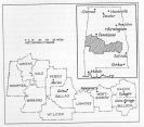
![[Location of Boykin (Gee’s Bend) in the context of Wilcox County.]](images/history_geography_wilcox.jpg) Location of Boykin (Gee's Bend) in the context of Wilcox County.
Location of Boykin (Gee's Bend) in the context of Wilcox County.
http://alabamamaps.ua.edu/counties/wilcox.html
Gee's Bend (officially renamed Boykin, Alabama) is a U-shaped peninsula five miles across and seven miles long, surrounded on three sides by the Alabama River. While there was once a ferry from Gee's Bend to the mainland and the county seat of Camden across the Alabama River, this ferry service ceased to operate in the mid-1960s during the Civil Rights Movement. The only access on and off Gee's Bend is a single road.
(Many thanks to Dr. Conner Bailey, Alumni Professor of Rural Sociology, College of Agriculture for help and guidance with geography of Gee's Bend and the Alabama Blackbelt and for assistance in locating user friendly, relevant maps.)