Update: Oct. 7, 2026, 5:00 p.m. (CT)
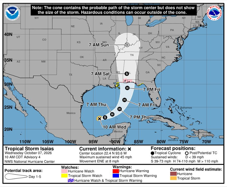
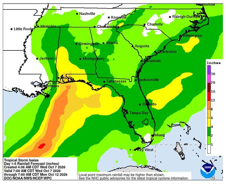
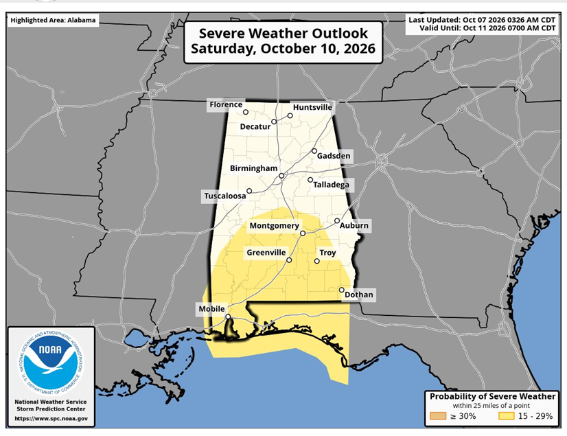
Latest forecast: Tropical Storm Isaias is now strengthening and will likely become a hurricane within the next 24 hours. Because the storm will be moving quickly and growing in size, impacts will reach well inland. Auburn should prepare for heavy rain, gusty winds and a low end tornado threat Friday evening into Saturday.
Timing and impacts for the Auburn University Community: No Changes From Previous Forecast
Forecast uncertainty:
Some model uncertainties still exist in regards to timing, intensity, and exact track, so refinements to this forecast are likely.
What you should do now:
- Make sure you're signed up for AU Alert and have a weather radio or Auburn University app with notifications turned on.
- Download the Auburn Weather app for current conditions and hour by hour forecasts.
- Charge phones and power banks; have flashlights ready.
- Secure loose outdoor items Thursday.
- Know where you'll shelter if a tornado warning is issued: lowest floor, interior room, away from windows.
- Never drive through flooded roads.
Fall Break Beach Goers:
- Coastal Alabama and the northwest Florida Panhandle are under a Hurricane Watch and Storm Surge Watch.
- Damaging winds, life-threatening storm surge, flash flooding, tornadoes, high surf and dangerous rip currents are possible.
- Storm surge of 5-7 feet is possible along portions of the coast Friday afternoon through Saturday morning.
- A high risk of rip currents will continue through the weekend.
- Surf could exceed 20 feet near and east of the storm's track.
- If traveling to the coast, closely monitor local forecasts and heed instructions from local officials.
Next update: Thursday, October 8, 2026, 8:00 a.m.
Update: Oct. 7, 2026, 2:30 p.m. (CT)
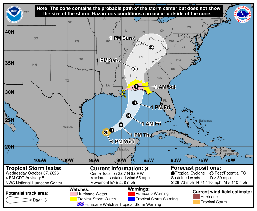
Latest forecast: Tropical Storm Isaias is forecast to strengthen into a hurricane before reaching the northern Gulf Coast Friday afternoon. Because the storm will be moving quickly and growing in size, impacts will reach well inland. Auburn should prepare for heavy rain, gusty winds and a low end tornado threat Friday evening into Saturday.
Timing and impacts for the Auburn University Community:
- Thursday: Dry for most of the day. Prep window for campus and residents.
- Friday afternoon–evening: Outer rain bands arrive; conditions begin to deteriorate Friday afternoon.
- Friday night–Saturday morning: Peak impacts in Auburn. Heaviest rain and strongest winds.
- Saturday afternoon: Improving as Isaias pulls north and away. Rain chances begin to deminish substantially by late morning into early afternoon.
What to expect:
- Heavy rain: 2-4 inches possible, with localized flash flooding in low-lying areas.
- Wind: Sustained 15-20 mph with gusts of 30-40 mph possible.
- Tornadoes: Tropical systems can produce brief, fast-forming tornadoes. If Isaias tracks along or west of the Alabama coast, Lee County could face an increased risk Friday night. Have multiple ways to receive weather alerts, especially overnight.
Forecast uncertainty:
Model guidance remains split on the exact track, and the National Hurricane Center has nudged its forecast slightly east. The stronger, faster solutions are on the eastern side of the guidance, which would bring higher wind and tornado risk closer to Auburn. Details will sharpen over the next 24–36 hours, so check back for updates.
What you should do now:
- Make sure you're signed up for AU Alert and have a weather radio or Auburn University app with notifications turned on.
- Download the Auburn Weather app for current conditions and hour by hour forecasts.
- Charge phones and power banks; have flashlights ready.
- Secure loose outdoor items Thursday.
- Know where you'll shelter if a tornado warning is issued: lowest floor, interior room, away from windows.
- Never drive through flooded roads.
Fall Break Beach Goers:
- Coastal Alabama and the northwest Florida Panhandle are under a Hurricane Watch and Storm Surge Watch.
- Damaging winds, life-threatening storm surge, flash flooding, tornadoes, high surf and dangerous rip currents are possible.
- Storm surge of 5-7 feet is possible along portions of the coast Friday afternoon through Saturday morning.
- A high risk of rip currents will continue through the weekend.
- Surf could exceed 20 feet near and east of the storm's track.
- If traveling to the coast, closely monitor local forecasts and heed instructions from local officials.
Next update: Wednesday, October 7, 2026, 5:00 p.m. (CT)