David T. King, Jr.
Geology Dept., Auburn University
The Wetumpka impact crater and the Late Cretaceous impact record [technical]
Drilling into Wetumpka impact crater, Alabama [non-technical]
Cross-section of Wetumpka impact crater, Alabama [non-technical]
The needle in the haystack: shocked quartz from Wetumpka impact crater, Alabama [non-technical]
Evidence confirming meteoritic impact at Wetumpka impact crater, Alabama [technical]
Late Cretaceous shallow-shelf impact in Gulf Coastal
Plain of Alabama [technical]
**********
THE WETUMPKA IMPACT CRATER
AND THE LATE CRETACEOUS IMPACT
RECORD
David T. King, Jr.
Dept. of Geology, Auburn University
Auburn, AL 36849-5305 USA
ACraters
are the most common topographic form on planetary surfaces in the inner
part of the solar system.@
-- Elbert A. King, Jr. (1976)
ABSTRACT
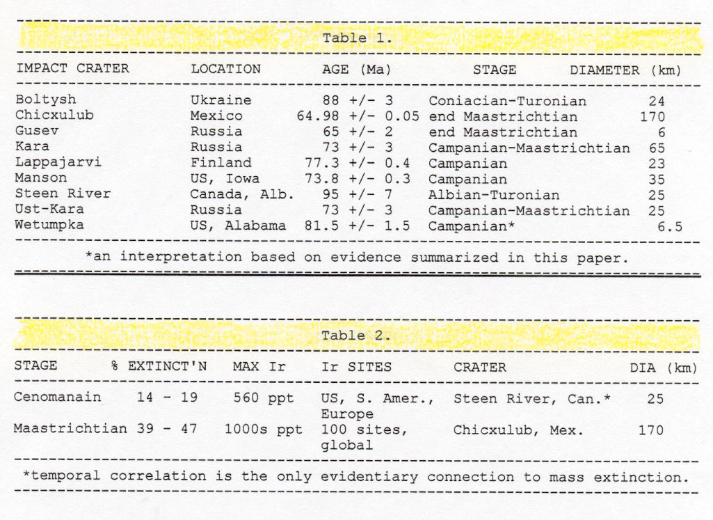
The Wetumpka impact crater in Alabama is a 6.5 km-diameter complex crater that likely formed during early Campanian (81.5 +/- 1.5 Ma). Wetumpka had an estimated original rim height of 210 to 360 m, and the center may have experienced an estimated 59 m of stratigraphic uplift resulting from impact. Wetumpka's impact probably occurred in 0 to 150 m of water and 0 to 50 km offshore from a barrier-island coastline. The impactor, a stony and(or) iron asteroid, is estimated to have been about 350 m in diameter. When the asteroid vaporized approximately 10-2 sec after surface impact, energy equivalent to between 102 and 103 MT of TNT (or between 4.2 x 1024 and 4.2 x 1025 erg) was released and thus opened a 3.3 to 4.2 km-diameter transient crater within approximately 11.5 sec. On a vegetated plain, both atmospheric peak over-pressure wave and infrared flash-burn combustion due to impact would have devastated a region estimated to have comprised 2.15 to 9.95 x 10⁵ hectares (or 830 to 3840 mi2). In shallow seawater, this impact would have generated a tsunami-like wave estimated to have been as much as 239 m high at a distance of five asteroid radii (875 m) from the target center. Terrestrial surface-wave magnitude of seismic shock-wave energy is estimated to have been 8.4 to 9. Wetumpka's impact-crater melange, at least 25 m thick, was likely formed by mass movement from the transient crater rim commencing after the first 18 to 21 sec. Wetumpka's horseshoe-shaped crater rim and associated interior northeast-trending aeromagnetic anomaly are evidence of an oblique impact by a cosmic object arriving upon a low-angle, northeast-to-southwest trajectory. The bearing of this trajectory is normal to the one proposed for the Chicxulub impactor, thus any connection between the Wetumpka and Chicxulub impacts, as has been suggested recently, is doubtful. Including Wetumpka, there are nine Late Cretaceous terrestrial impact craters known, ranging in size from 6 to 170 km diameter, and all are situated in the northern hemisphere. Two of these impact craters are temporally correlated with global marine mass extinctions. Steen River impact crater (25 km diameter; Canada) may be related to the terminal Cenomanian (91 Ma) mass extinction of 14 to 19 percent of all marine genera. Chicxulub (170 km diameter; Mexico) is firmly established as a significant causal factor in the well-documented terminal Maastrichtian (65 Ma) mass extinction that included 39 to 47 percent of all marine genera and many terrestrial genera as well.
THE WETUMPKA IMPACT CRATER
The town in Elmore County, Alabama, giving its name to the Wetumpka impact crater took its unusual-sounding name from a term in the Creek native people's language: Awe-tum-cau@ which is derived from the union of Awe-wau@ (water) and Atumcau@ (rumbling; Read, 1984). Thus in Creek language, Wetumpka means Arumbling water,@ or alternatively Asounding or tumbling water.@ These names are not entirely inappropriate for an impact crater that probably formed in shallow Gulf waters during the Late Cretaceous.
Discovery of unexpected geologic features near Wetumpka dates back over 100 years, but the interpretation that Wetumpka is an impact crater is relatively new. Peculiar structures and apparent anomalies in local stratigraphy have been noted in several separate mapping projects going back to 1891. Field notes of August 7, 1891, written by State Geologist and University of Alabama Professor Eugene Allen Smith tell of his puzzlement over unusual coastal plain-crystalline geology in a small area near Wetumpka. His AReport of the State Geologist@ presented to Governor Thomas G. Jones on July 1, 1894, contains Professor Smith's first published remarks about unusual geology near Wetumpka, Elmore County. In Part III of the Report, he says:
In his 1894 Report, Professor Smith goes on to describe fossils found in what he refers to as ARotten Limestone@ (i.e., Mooreville Chalk). He recounts seeing AExogyra costata, Inoceramus, and fragments of Radiolites lamellosus@ which he describes as being coeval with his AHamburg beds@ (Smith et al., 1894). Professor Smith's Hamburg beds were phosphate-bearing strata originally cropping out Ain Spencer's Field, Hamburg, Perry County.@ According to Szabo (1973), phosphatic strata at Hamburg are confined to the Mooreville Chalk's lowermost 1.5 m.AOn the east side of the river we do not find the geological structure quite easy of determination. The crystalline rocks underlie all the county down to Wetumpka and Tallassee ... (but) such does not seem to be the case ... a few miles (and) a little south of east of Wetumpka at Mr. Adam Enslen's in section 20 ... (there) at the foot of a ridge of gneiss, there are several acres of outcrop of Cretaceous strata which from their general aspect and the character of the fossils probably represent the lowermost beds of the (Mooreville Chalk) ... Now when one considers that the (Mooreville Chalk) sets in ... this range of hills ... these outlying tracts become difficult to explain except upon the supposition of a depression of several hundred feet, the whole thickness of the Eutaw strata and perhaps more, along the border of the crystalline schists ... A (Smith et al., 1894, p. 550-552).
On the first modern Geologic Map of Alabama (Stose, 1926), the Wetumpka impact crater area is shown as two rectangular fault-bounded outliers (i.e., grabens) connected to one another in an L-shape. This L-shaped structure is comprised of a longer northeast-oriented graben, 4.6 by 1.9 km, normal to a shorter northwest-oriented graben, 2.5 by 1.0 km. The larger graben directly abuts the smaller graben's northeastern side so that taken together an L-shape is formed. According to the map, both grabens contain Eutaw Formation and ASelma chalk.@ In both grabens, the Eutaw-Selma contact strikes northwest, but in the larger graben apparent dip is northeast and in the smaller graben, southwest. The larger graben is surrounded on the north by AAshland mica schist.@
Until careful research was conducted during 1970-1972 by Thornton L. Neathery and his colleagues Robert D. Bentley and Gregory L. Lines, no one had connected Wetumpka's disturbed geology with an impact event (Neathery et al., 1976). In the Preface to his book, the first monograph ever written on impact cratering, Melosh (1989) gives a substantial reason why extraterrestrial factors were rarely ever considered in an instance like Wetumpka:
In their paper, Neathery et al. (1976) refer to Wetumpka as a Acryptoexplosive structure@ in the title, and go on to name it an Aastrobleme@ in the text in order to emphasize their contention that the structure was of extraterrestrial origin. Such oblique terms were probably necessary in the scientific climate of the 1960s and 1970s where heavy scepticism about any significant, post-primordial impact record on Earth still abounded. Such scepticism has waned considerably as noted in the passage above.AAs recently as 1950 most astronomers believed that the lunar craters were giant volcanos, and all but a few geologists derided the idea that the Earth's surface has been scarred by impact structures kilometers in diameter. A similar lack of appreciation led the eminent geologist G.K. Gilbert in 1896 to reject impact as the process that created Meteor Crater, Arizona. (Now) impact cratering has risen from complete obscurity to become one of the Amost fundamental@ geologic processes. One meteoriticist has even suggested that future historians will accord the recognition of impact cratering as equal importance with the development of plate tectonics.@
For an additional historical perspective on the study of Wetumpka's impact crater, see the recent article by Hall (1996) in Alabama Heritage.
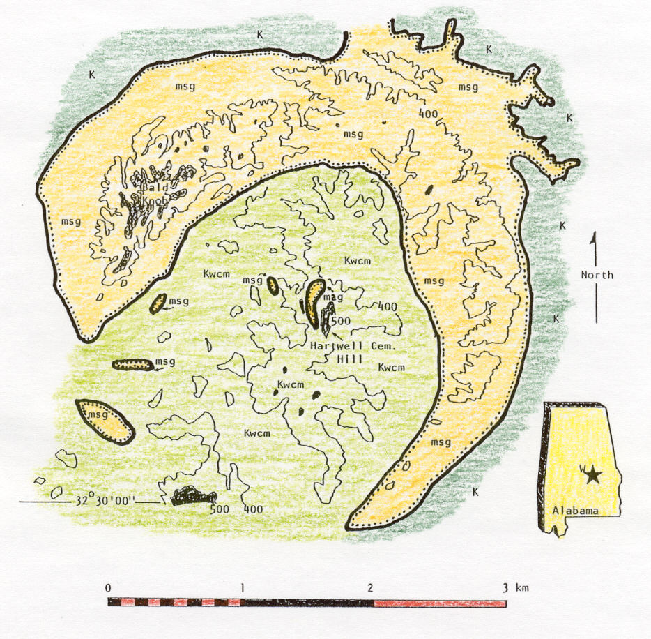
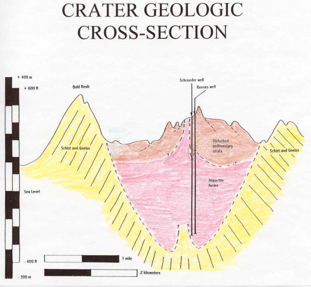
Anyone driving north on US 280 from Montgmery has seen the northwest rim of the impact crater jutting from beneath sandy coastal-plain and alluvial cover on the highway's eastern side as one enters Wetumpka's city limits. A small forest of transmitting towers crowns Bald Knob, highest point on the eroded northwest rim (elevation 178.8 m or 586.6 ft). The impact-crater rim, breached on the south and southwest, is clearly visible on both the USGS 7.5-minute Wetumpka orthophotoquad and quadrangle. The crater rim is especially well defined by looking at elevations above the 400 ft contour line (Figure 1). In false-color satellite imagery from a 920-km orbit, the impact crater is clearly visible as a dark-red spot (see State of Alabama Uncontrolled ERTS-1 Mosaic by Svehlak and Sapp, 1972-3). Wetumpka's impact crater center is located at 32o31'42"N, 86o14'12"W (Neathery et al., 1976).
Neathery et al. (1976) described and interpreted all available field data in their published paper, and I will not attempt to reiterate that here. For their work, the reader is referred to the original paper which appeared in the Geological Society of America Bulletin (and was reproduced by the Geological Survey of Alabama, Reprint Series 44, and also appears reprinted in Alabama Geological Society Guidebook 34C, The Wetumpka impact structure and related features). In the section below, I would like to add some additional observations and interpretations about Wetumpka's: (1) possible age; (2) rank of shock effects; (3) paleogeographic setting; (4) shape and diameter; and (5) environmental effects due to impact.
Before turning to those discussions, I want to mention a connection between Wetumpka's impact crater and what arguably must be the most bizarre form of stratigraphic leakage ever described. In the original abstract announcing discovery of Wetumpka's impact crater, Bentley et al. (1970) refer to a centrum from a polycotylid pliosaur, Discosaurus (within a small block of Mooreville Chalk), that was embedded, owing to impact pressure, within strata of the Tuscaloosa Formation at Wetumpka (see Thurmond and Jones, 1981). Thus, by extraterrestrial force, an early Campanian vertebrate fossil was thrust down into a Cenomanian formation.
ADDITIONAL OBSERVATIONS
AND INTERPRETATIONS ABOUT WETUMPKA
Wetumpka's possible age. -- Neathery et al. (1976) use classic relative age-dating principles in order to bracket the impact-crater age between Apost-Mooreville (Late Cretaceous) and post-terrace (Pleistocene).@ Their reasoning came as a result of (1) finding blocks of Mooreville Chalk as the youngest coastal-plain stratigraphic unit within the impact-crater melange and (2) horizontal crater-floor deposits of (what is generally regarded as) Pleistocene Ahigh terrace deposits.@ In assessing minimum age of Wetumpka's impact crater, an important fact is absence of the Arcola Limestone Member, uppermost member of the Mooreville Chalk, within the impact-crater melange and all grabens associated with the impact crater. The Arcola is a persistent and ubiquitous (albeit very thin) deposit across Alabama's Coastal Plain, and absence of these limestone beds suggests that the Wetumpka impact event is pre-Arcola. Apparently, Mooreville Chalk, a lower Campanian marl unit in central Alabama (King and Skotnicki, 1994), was Wetumpka's youngest target material.
Professor Eugene Allen Smith's observations on Mooreville fossils and strata within his Adepression@ near Wetumpka caused him to correlate Wetumpka beds with lowermost Mooreville strata he had seen and described near Hamburg, Perry County, Alabama (Smith et al., 1894). Professor Smith was a keen observer and a geologist with vast mapping experience gained during Alabama's pre-development era in every county of Alabama's Coastal Plain. He identified the Mooreville at Wetumpka as lowermost Mooreville. This suggests to me that the Mooreville's upper part, including the Arcola, is missing at Wetumpka not because of post-impact erosion within and around the impact crater, but rather because upper Mooreville and the Arcola were deposited in shelfal areas far from Wetumpka's impact crater and long after impact.
If any of what we now call upper Mooreville, Arcola, or Demopolis (or any Tertiary units) were present in the Wetumpka area, I suspect that Professor Smith would have seen and made note of their occurrence. I think a compelling bit of evidence for a minimum latest Cretaceous age of Wetumpka is lack of any blocks from any Tertiary formations within the crater melange. Crater melange fills the area inside Wetumpka's rim and contains a blocky potpourri of saprolitized and relatively unaltered pre-Cretaceous piedmont lithologies, Tuscaloosa and Eutaw Formations, Mooreville Chalk, but no other units.
All the above points to a post-Eutaw, but pre-Arcola age (i.e., younger than 83 Ma, but older than 80 Ma) for Wetumpka's impact crater. The Mooreville Chalk has been correlated with global sequence stratigraphy and that correlation gives us an early Campanian age range of 81.5 +/- 1.5 Ma (King and Skotnicki, 1994). The Arcola's age has been estimated at 80.5 +/- 0.5 Ma (King, 1990). If Professor Smith's assessment of lowermost Mooreville stratigraphic position is correct, Wetumpka's impact-crater age should be somewhere in the older part of the age range 81.5 +/- 1.5 Ma.
In order to determine the time of impact any more accurately, lithostratigraphic evidence needs to be uncovered that will document some collateral damage resulting from the energy released. Detailed lithostatigraphic studies in the southeastern region, especially Alabama, conducted over the past 50 years have not yielded any descriptions of intra-Cretaceous beds that are interpreted to be: (1) affected by seismic and(or) tsunami waves; or (2) comprised of debris flows, ejecta-curtain deposits, or tektite strewnfields that can be connected with the Wetumpka impact. However, it is important to note that mappers and stratigraphers were not specifically looking for such features. Synsedimentary disturbed and disrupted beds, both with and without clastic dikes and ball-and-pillow structures, have been described in the Tuscaloosa and Eutaw Formations (Frasier, 1979) and in the Blufftown Formation (Reinhardt and Gibson, 1980; Skotnicki, 1985). The Tuscaloosa and Eutaw Formations are too old to have been affected by Wetumpka's seismic- and(or) tsunami-wave action during their deposition, however beds in the Blufftown, coeval with the Mooreville, likely deserve some more attention and study. Both Reinhardt and Gibson (1980) and Skotnicki (1985) illustrate enigmatic disturbed zones within the upper part of the Blufftown Formation.
Wetumpka's rank of shock effects. -- Neathery et al. (1976) examined some thin sections of gneiss and schist samples from Wetumpka's southern crater rim. They describe Wetumpka shock features as: (1) Aplagioclase feldspar crystal(s) exhibiting kink banding of twinning lamellae;@ (2) Abiotite crystal (that) are bent and strained;@ (3) deformed twinning lamellae in feldspars that show a Achange in isotropism along lamellae in zone of distortion (grey to black), (that) indicate(s) a change in refraction index and extinction angle@ under crossed nicols; (4) Aquartz grains with undulatory extinction ... many exhibit(ing) ... planar features with discontinuous undulatory extinction;@ (5) Ahighly shocked quartz crystals exhibiting two sets of planar fracture ... (with) discontinuous undulatory extinction along set 1 (NE-SW) cross(ing) set 2 (NW-SE) with minor offsetting (as seen under) crossed nicols;@ and (6) Amortar texture of crystallite along cleavage suggestive of shock shear.@ They note that none of the above features are seen in thin sections of similar piedmont rock units locally or regionally, except in the impact-crater rim. They further note that Ano shock features such as coesite, shatter cones, or impactite have been found within the (impact crater).@
According to Koeberl (1994, cited in Koeberl and Anderson, 1994), planar fractures and planar-deformation features form under impact pressures in the range of 5 to 45 GPa, high-pressure polymorphs (e.g., coesite and stishovite) under 15 to 50 GPa, and shatter cones under 2 to 30 GPa. Therefore, absence of high-pressure polymorphs and presence of planar-deformation features suggests Wetumpka impact pressures against the southern rim (as examined by Neathery et al., 1976) were in the range of 5 to 15 GPa (same as 50 to 150 kBar). Absence of shatter cones may at first seem puzzling, however, as a recent review of shatter cone-producing deformation processes makes clear, Ashatter cones are best developed in fine-grained, homogenous rocks; less well developed in coarse heterogenous rocks@ (Sharpton et al., 1996). Wetumpka target-area piedmont metamorphic rocks are very coarse and mineralogically heterogenous. Nevertheless, the writer has found what he interprets to be poorly developed shatter cones in biotite schist at a site on the inside of the northwest rim. The shatter-cone site is in a stream draw, about 0.2 km northeast of Sec. 19's center and about 0.7 km south-southwest of Bald Knob's high point. Poorly developed shatter cones were found on a slump block fallen from the rim and generally comprised float, therefore no preferred orientation of shatter cones could be determined.
Wetumpka shock effects described by Neathery et al. (1976) and cited above are microscopic evidence of what we now refer to as planar fractures (PFs) and planar deformation features (PDFs). Koeberl and Anderson (1996) say that PFs and PDFs are Agenerally accepted to be diagnostic evidence of shock.@ Wetumpka's PFs and PDFs resulted from violent compression of rock by impact- generated supersonic shock waves that raised constituent minerals beyond their Hugoniot elastic limit, the point where sudden high pressure causes irreversible structural changes.
During an extensive study of a wide range of shocked materials at the Reis impact crater in southern Germany, Chao et al. (1978) established a widely used ranking scale for relative description of shock effects in terrestrial impact craters. The ranking (or degree) of shock established at Reis runs from 0 to 7 (where 7 is most shocked). Level 0 is unshocked, showing no microfractures and original unbleached color. Level 1 contains closely spaced microfractures and kinked mica. Level 2 contains shocked lamellae in both quartz and feldspar and anomalous fractures in quartz. Level 3 is bleached and contains thetomorphic (diaplectic) glass with no vesicles, vitrified quartz, and kinked micas. Wetumpka impact crater's rocks contain apparent level 0 through 2 features, according to the data and figures in Neathery et al. (1976). No level 3 (or higher level) features are still present, if they ever existed.
Wetumpka's trough-like aeromagnetic anomaly which displays a maximum magnetic relief of 1548 gammas (or 0.015 Gauss; Neathery, l983) at the concavity of the horseshoe-shaped rim is a direct shock metamorphic effect in the impact crater's crystalline target. Grieve and Pilkington (1995) state that Amagnetic anomalies related to impact may be caused by one or more of several mechanisms ... at peak pressures of (approximately) 1 GPa, shock demagnetization can remove existing remnant magnetization ... and, at pressures of (greater than) 10 GPa, magnetic susceptibility can be reduced ... (further) target rocks can also acquire a shock remnant magnetization in the direction of Earth's field at the time of impact.@ Whatever the exact shock metamorphic mechanism, the position of the magnetic anomaly at Wetumpka is best explained by extraterrestrial impact pressure.
Absence of petrographic shock effects in the interior of Wetumpka's impact crater appears to result from a lack of basement derived and relatively unweathered piedmont crystalline rocks in the rebounded central peak area and all other areas of the impact-crater floor. That piedmont blocks within the impact-crater melange would lack shock effects is not unexpected considering that during excavation stage of crater formation Athe great bulk of material is removed ... under conditions of low stresses and modest ejection velocities@ (Gault et al., 1968). Further, and perhaps more importantly, transient-crater rim collapse likely produced large-scale sliding of peripheral slump blocks (Melosh, 1989). These slump blocks, made of unshocked strata from the transient-crater rim, would have immediately filled Wetumpka's floor with a thick, apparently unshocked, chaotic crater-floor deposit called herein crater melange. I think this is the origin of what Neathery (1983) recounted as Aunique stratigraphic relationships and abnormal unit thicknesses ... interpreted to indicate ... complex geometry of the observed structure.@ I predict crystalline rocks beneath the cover of crater melange are highly shocked.
Asymmetry of Wetumpka's crater actually may account for petrographic shock effects present in the south rim (reported by Neathery et al., 1976) because shock effects would be asymmetrically distributed (Melosh, 1989). Geieve and Pilkington (1995, their Figure 8 and their Table 2) show that petrographic shock effects are confined to the central target, but their analysis is based on examples of symmetrical simple craters that were produced by high-angle impacts. One of Richard Grieve's impact crater-analysis team at the Geological Survey of Canada (Janice Smith, personal communication) recently told me that, in order to be valid evidence of impact-generated pressures, petrographic shock effects must come from the center, not the rim. However, that criterion is likely not applicable in this instance because of the apparent asymmetrical distribution of shock pressure within the impact- crater. Shock pressure could have been higher on Wetumpka's southern rim due to the trajectory (Melosh, 1989).
Indirect physical evidence resulting from asymmetry of shock pressure is impact-related multiple graben development on the downrange (or open) side of Wetumpka's impact crater. Neathery et al. (1976, their Figure 2A, a geological map) illustrate three grabens outside Wetumpka's impact-crater rim that all have northwest strikes and contain Mooreville Chalk at the surface. Graben spacing is 1 km apart and each has a near-equal width of 175 m along their strikes. Neathery (1983) interprets these features as Aextensional adjustments during rebound.@ If so, these grabens are compelling evidence of asymmetrical impact and resulting asymmetrical distribution of shock pressures. Such impact-related grabens are not associated with symmetrical impact craters from non-oblique impacts (Melosh, 1989).
Before turning away from consideration of shock features, I note a second, less likely explanation for shock-feature distribution at Wetumpka. What if Wetumpka's crystalline rim is really only some larger feature's central peak or peak ring? That may seem astounding at first, but such a scenario accounts for the distribution of shock features reported by Neathery et al. (1976) within Wetumpka's 6.5 km-diameter crystalline rim. What would such an impact crater be like? Using Melosh's (1989) ratio of 1:4.5, the diameter of this proposed crater would be slightly over 29 km. Perhaps then we should be looking at a radius of 14.5 km for terraces and concentric, bounding normal faults delineating the real impact-crater rim? Unfortunately, most territory within a 14.5 km radius of Wetumpka is covered by Quaternary alluvium and the state geologic map offers no clues visible at a scale of 1:250,000 that will help resolve this matter (Szabo et al., 1988).
Wetumpka's paleogeographic setting. -- Neathery et al. (1976) note that the Wetumpka impact crater is Aunique@ in its geologic setting because Anowhere along 1600 km of coastal plain-piedmont (fall-line) is there reported a combination of geologic conditions and effects that so clearly defines an impact structure.@ Considering that the Late Cretaceous shoreline approximately paralleled the arcuate modern fall line, the target area was likely just a few 10s of km offshore (assuming Late Cretaceous impact). Neathery et al. (1976) favor a near-shore or shallow-offshore impact site in order to account for the general low level of shock features present at Wetumpka. In their view, a layer of water and(or) water-laden sediments might have absorbed, and thus dissipated, some of the kinetic energy.
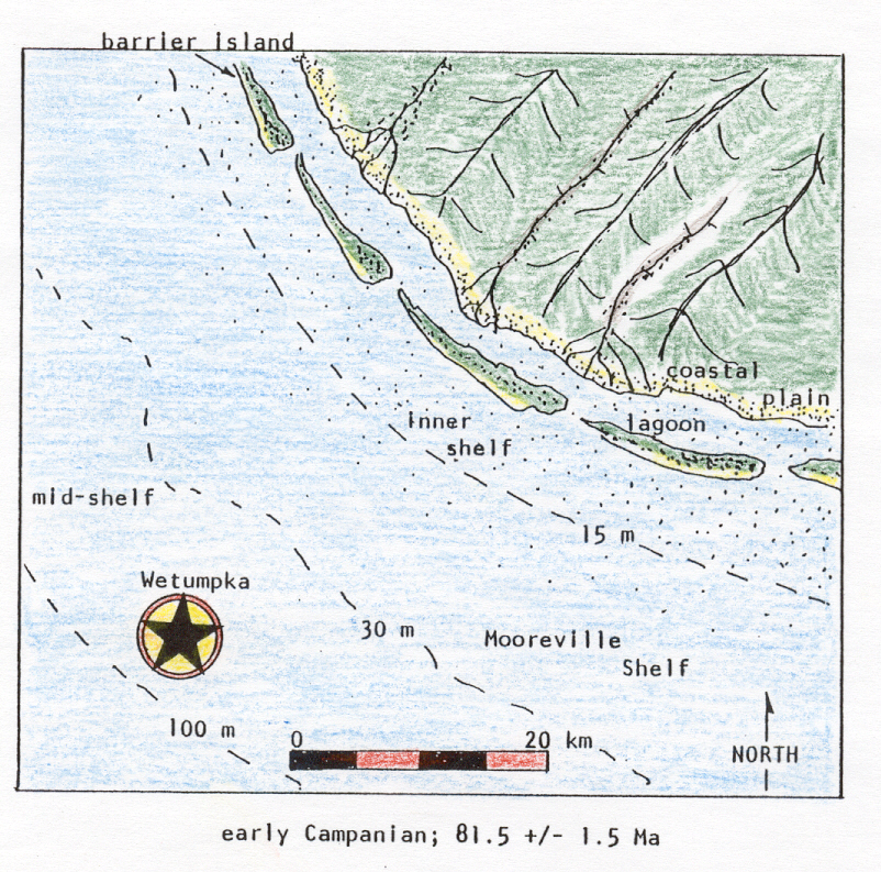
According to paleogeographic reconstructions either described or implied by King (1994) and King and Skotnicki (1994) and references cited in these papers, specific target environments of deposition for Wetumpka would have depended upon time of impact. During early Campanian, the favored time span for impact at Wetumpka, Mooreville Chalk at the target was being deposited in a shallow middle-shelf hemipelagic environment, 30 to 40 km offshore, under 30 to 100 m of seawater (Figure 2). During late Campanian, Demopolis Chalk deposition was in progress on a shallow hemipelagic middle-shelf, 40 to 50 km offshore and at 50 to 150 m water depth. During early and early-late Maastrichtian, deposition of the Ripley Formation's barrier-island coastline with extensive adjacent flood tidal-delta region and a wide foreshore subtidal clastic belt was occurring essentially at the strand-line and at mean sea level. Finally, during late late Maastrichtian (Prairie Bluff Chalk deposition), a shallow middle-shelf hemipelagic environment existed at the target, 20 to 30 km offshore and under 30 to 50 m of seawater.
There is no evidence that Wetumpka's impact crater ever influenced any facies patterns, depositional strikes, clastic contents, or biofacies in any of the Late Cretaceous or Tertiary units in Alabama or elsewhere. Therefore, as a paleogeographic and paleotopographic feature, the impact crater does not register.
Wetumpka's shape and diameter. -- Crater size of an intensively eroded crater such as Wetumpka is best judged by considering the distance between the outermost of several concentric or arcuate normal bounding faults on opposing sides (Melosh, 1989). These outer bounding faults represent planes of detachment for outermost crater-wall terraces. Such terraces (i.e., slump blocks) develop in complex craters as gravity acts to take the developing crater from transient to final form (Melosh, 1989).
Along a northwest-southeast transect (see line A-A' on Figure 2A in Neathery et al., 1976), linear distance from the easternmost mapped concentric normal fault (NW 1/4, Sec. 35) to the westernmost tangentially striking foliation (in the Coosa River, SW 1/4, Sec. 18), is approximately 7.75 km. In their Figure 2B, a generalized cross-section along the transect line, additional concentric bounding faults are implied that could increase the diameter to almost 10 km, according to Melosh's definition. Neathery et al. (1976) give a 6.5 km diameter, but do not say where that diameter was taken.
On the current State Geologic Map of Alabama (Szabo et al., 1988), crystalline piedmont rocks (specifically the Emuckfaw Group) comprising Wetumpka's impact crater rim crop out as an imperfectly horseshoe-shaped inlier. A northeast-southwest transect across the inlier on the State Geologic Map is 6.1 km from side to side. Alvarez et al. (1993) assess Wetumpka's diameter as 5 km. Looking only at the uplifted crystalline rim on a Wetumpka 7.5-minute quadrangle, the distance from transmitting towers on Bald Knob directly across to the highest erosional remnant on its eastern rim (0.22 km SW of center, Sec. 22; survey control point marked 496 ft (151 m)), is approximately 4.3 km.
According to Melosh (1989), simple impact craters are relatively small, smoothly contoured bowl-shaped features without slump blocks or central rebound uplifts. Complex craters are larger, with one of two types of central rebound uplifts (simple peak or peak ring) and terraced walls. On the Moon, simple craters have diameters less than 10 to 20 km and on all planetary bodies have depth-to-diameter ratios of 1:5 to 1:3 (Melosh, 1989). Complex impact craters have much smaller ratios. Wetumpka's terraced crater walls and central peak (or peak ring?) clearly show it is a complex, not a simple, crater even though it is less than 10 km in diameter. Wetumpka has a modern depth-to-diameter ratio of 1:75 (i.e., 87:6500), which is not consistent with typical, terrestrial complex cratering in that the denominator is relatively high (Grieve and Pilkington, 1995).
Crater-rim slumping during transient impact-crater collapse combined with significant post-impact erosion apparently to obscure or at least make unclear definitive conical or concentric topography attendant to Wetumpka's central peak or peak ring. Figure 1 depicts significant high ground within Wetumpka's crater interior along a north-south drainage divide that encompasses Wetumpka's peak or peak-ring center, located at or near Hartwell Cemetery Hill (NW 1/4, NW 1/4, Sec 28). Hartwell Cemetery Hill, central high point on Wetumpka's impact-crater floor (approximately 545 ft or 166 m) is covered by approximately 7.6 m of Quaternary high-terrace alluvium (see Figure 2A in Neathery et al., 1976). An inlier of potassium-feldspar augen gneiss (unit mag in Neathery et al., 1976, but called Kowaliga Gneiss by Szabo et al., 1988) is apparently a deeper crystalline target rock than Wetumpka's crater- rim biotite-muscovite-plagioclase schist and gneiss (unit msg in Neathery et al., 1976, but also called Emuckfaw Group by Szabo et al., 1988). Unit mag crops out in a 0.1 km2 oval-shaped area, located approximately 0.5 km northwest of Hartwell Cemetery Hill's high point (see Figure 2A in Neathery et al., 1976), and this augen-gneiss unit may be part of the peak ring or simply the peak itself.
Modern intra-crater topography, including the former peak or peak-ring area, is apparently controlled more by Holocene stream erosion than by impact- related geology. A central north-south drainage divide bisects the crater, with Hartwell Mill Creek drainage generally toward the east and other dendritic drainage toward the west into the Coosa River. Holocene erosion was apparently rather rapid judging from the lack of antecedent streams (one exception is 1.5 km east of Bald Knob in SE 1/4, Sec. 17) and presence instead of annular drainage patterns on the impact crater's eastern side and radial drainage patterns on the northwestern side.
Using Melosh's (1989) central-peak diameter to crater-rim diameter ratio for terrestrial planets (1:4.5), Wetumpka should have had a 1.5 km diameter central peak or peak ring. However, Grieve and Pilkington (1995) caution that Asome complex impact structures in sedimentary or mixed targets with sediments overlying crystalline basement do not appear to develop a topographically high central peak.@ Initial development of a peak ring is viewed likely at Wetumpka because of the unconsolidated and thus potentially plastic nature of the Upper Cretaceous section comprising target layers above basement. Plasticity of crater-peak material is one key factor in the phenomenon of peak collapse requisite to peak-ring formation (Melosh, 1989). Time to central peak rise (T) can be determined by: T = (D/g)0.5, where g is the acceleration of gravity (9.8 m/sec2; Melosh, 1989). For Wetumpka's central peak, rise time was approximately 26 sec.
Neathery et al. (1976) present a cross section showing the southeast terraced wall extending from Hartwell Mill Creek to just beyond the southeastern limit of impact-related structure (A' in their Figure 2B). This span described above is 3 km, and that distance is taken to be a fair estimate of Wetumpka's southeastern terrace width (as defined by Melosh, 1989). According to Melosh's terrace width-to-crater diameter ratio of 1:20, an impact crater with terrace width equal to 3 km should be part of a complex impact crater that is 60 km in diameter. Obviously, Wetumpka is not that large! The inapplicability of Melosh's ratio stated above is probably due to target composition: an unconsolidated sediment between a layer of shallow seawater and crystalline basement. Grieve and Pilkington (1996) note that terrestrial impact craters are commonly terraced at diameters as little as 2 to 4 km.
Grieve and Pesonen (1992) defined the following relationship between apparent depth (da) and impact-crater diameter (D): da = 0.12D0.30 or da = 0.15D0.43 for sedimentary or crystalline targets, respectively. According to Grieve and Pilkington (1996, their Figure 2), apparent depth (da) is the difference in elevation between Aoriginal (target) ground surface@ and the modern top of Aallochthonous materials ... partly filling the structure.@ Taking Wetumpka's diameter as 6.5 km, apparent depth (da) equals 210 or 360 m, respectively, depending upon target material. Thus, Wetumpka originally had a depth to diameter ratio of 1:31 or 1:18, depending upon target material.
At Wetumpka, modern impact-crater depth (maximum rim relief given by Neathery et al., 1976) is 87 m, thus, depending upon target, 123 to 273 m of computed apparent depth is now missing. Wetumpka's missing relief is comprised of erosional loss from rim height and minor sedimentary filling of crater floor. Because both crystalline basement and sedimentary cover were involved in impact deformation, Wetumpka's rim would have been composed of both materials. Rapid denudation rates in Alabama's tropical to subtropical environments since Late Cretaceous could easily have lowered Wetumpka's rim by stripping off all sedimentary formations. According to Neathery (1983), sedimentary thickness at Wetumpka is 122 m in subsurface drill core. Adding an extra 122 m to Wetumpka's existing rim relief of 87 m makes the original rim height at least 209 m, a height like that computed for sedimentary targets above.
Stratigraphic uplift (SU) of a complex crater can be computed by SU = 0.086D1.03, according to Grieve and Pilkington (1995) who carefully studied a population of 24 terrestrial impact craters in order to derive this formula. For Wetumpka, SU is computed as 59 m. Grieve and Pilkington describe SU as Athe amount of stratigraphic uplift undergone by the deepest lithology now exposed in the center.@ At Hartwell Cemetery Hill, the oldest target unit, labeled mag (augen gneiss of Neathery et al., 1976), crops out at a maximum elevation of 152 m. From Wetumpka's SU value, we can infer that unit mag was at an approximate maximum elevation of 93 m at time of impact. Unit mag has an intrusive relationship with the other piedmont target unit, msg, and we do not know msg's thickness overlying mag at the target. However, if unit msg's thickness was negligible and we use an average modern crater- floor elevation equal to approximately 118 m, simple subtraction indicates at least 25 m of crater melange overlies piedmont bedrock. Neathery et al. (1976) examined drill data from Wetumpka's impact crater and drew a schematic cross section (their Figure 2B) showing all material above piedmont bedrock as a Acrater melange@ with no overlying bedding sedimentary target material. I think at least 25 m of gravity-emplaced crater melange apparently filled Wetumpka just after impact.
From the above, we can compute a true depth (dt) for Wetumpka by adding apparent depth (da, value range given above) and a minimum thickness of crater melange. Thus, apparent depth is 255 to 405 m, depending upon target.
Wetumpka's crater melange, roughly what Grieve and Pilkinton (1995) refer to as an Aallochthonous breccia lens,@ is a chaotic mixture of piedmont and sedimentary clastic particles ranging from + 14.5 phi to - 14.5 phi (0.03 micron-sized clay to 23 m-diameter boulders). In this chaotic mix, internally deformed as well as relatively undeformed megaboulders are commonly supported upon one another with a sheared, finer-grained interstitial matrix. Melosh (1989) discusses a proposed mechanism of emplacement and source for impact- crater Abreccia lenses@ wherein transient crater walls collapse during the whole cratering event. Thus, Wetumpka's crater melange is not likely a fall- back breccia, as has been suggested, but rather a mass-movement deposit. Wetumpka's asymmetry argues for crater-melange provenance from the extant crater-wall region because that was the former high up-range rim.
Estimating from data and computations in Melosh (1989), time to formation of Wetumpka's transient crater would have been about 11.5 sec. Melosh says the time to initial transient-crater rim collapse scales as (Dt/g)0.5, where Dt is the transient-crater diameter. Melosh also says transient-crater diameter, Dt, is less than final diameter, D, according to Dt = 0.5 km (D) to 0.65 km (D). With Wetumpka's D = 6.5 km, and transient-crater diameter ranging from 3.3 to 4.2 km, time to initial transient crater-rim collapse ranges from 18 to 21 sec. Therefore, initial transient-crater rim collapse therefore occurs just before maximum central-peak rise time (computed earlier).
Judging from descriptions in Neathery et al. (1976) and Neathery (1983) and my own observations, is seems internal stratigraphy of Wetumpka's crater melange may be divided into two parts: (1) crater melage comprised of deformed blocks of Upper Cretaceous strata and clastic matrix; or (2) crater melange comprised of deformed blocks of crystalline piedmont rocks and sheared piedmont matrix. Piedmont crater melage shows either schist-gneiss or augen-gneiss blocks in sheared matrix (respectively, units msg and mag of Neathery et al., 1976, their Figure 2A). It is unclear whether these are crater- melange facies that are strictly laterally related or whether these facies have a vertical relationship as well. Understanding these crater-melange facies relations may shed light on mode of emplacement and timing of mass movement of material off the transient impact-crater rim.
Wetumpka's eroded, horseshoe-shaped rim led Neathery et al. (1976) to speculate on an oblique impact from a Atrajectory possibly inclined to the south.@ Simple erosional breaching of Wetumpka's impact crater on the open side, if it ever was a viable hypothesis to explain shape and asymmetry, seems very unlikely now considering aeromagnetic survey results that show a distinctive anomaly. Neathery (1983) described this anomaly as Aa small deep northeast-trending magnetic low coincident with the general configuration of the surface structure@ of the impact crater. Melosh (1989), citing hypervelocity experiments, notes that only highly oblique impacts (angle less than 10 degrees) create asymmetrical impact craters. These asymmetrical impacts make craters with a rim located on the same side as the approach trajectory. Such rim development is due to the fate of the impactor because it disintegrates and is jetted horizontally uprange (in the direction of travel; Melosh, 1989, see his Figure 4.3). Taking from this experimental evidence, we can conclude that the Wetumpka impactor was on a northeast-to-southwest trajectory at a very low angle above the horizon.
Recent modeling studies intended to shed light on the origin of the Chicxulub impact crater in the Yucatan peninsula have indicated an oblique impact was responsible for that asymmetrical crater, now estimated to be 170 km in diameter. The trajectory of the Chicxulub impactor, according to Schultz and d'Hondt (1996) and other workers, was 20 to 30 degrees above horizontal along a southeast-to-northwest path. Alvarez et al. (1993) draw a connection between Chicxulub and Wetumpka because of their ages and oblique angles of impact and suggest that Wetumpka's impact crater may be a Asecondary crater, produced by a (Chicxulub) ricochet fragment.@ If there is ever a more substantial connection established between Chicxulub and Wetumpka, which I doubt, separate trajectories on bearings 90 degrees to one another will have to be explained.
Up to now, our presumptions about Wetumpka's impactor were that it was a stony, stony-iron, or iron asteroid. Because stony asteroids are the most common type of asteroid, we should infer a stony impactor in the absence of other data. But what if a comet struck at Wetumpka instead? Inactive comets have nuclei that are probably like most asteroids and would behave on impact as stony or iron asteroids, except if their nuclei were unconsolidated and thus prone to disintegration in Earth's atmosphere (Rahe et al., 1994). Some active long-period and short-period comets both have had, and will have, Earth-crossing orbits. Presently, 20 to 30 percent of potential Earth impactors are such comets (Shoemaker et al., 1990). Generally speaking, kinetic energy imparted upon cometary impact is in direct relation to size and integrity of the cometary nucleus as well as the incoming comet's speed. Incoming speeds for comets are higher than for asteroids, and depending upon the origin of the comet (i.e., from inside or outside the solar system), velocities may range up to 72 km/sec (Rahe et al., 1994). Thus, a comet with a massive stony or iron nucleus perhaps significantly less than 6.5 km in diameter could have created Wetumpka's crater owing to its greater cosmic velocity. However, comets tend to have some characteristics that diminish their effectiveness as crater makers: (1) their trajectories tend to cause tidal disruption and breakup as they approach Earth and pass Roche's limit; (2) their higher velocities, lower bulk densities, and lower bulk material strengths (versus asteroids) tend to reduce survivorship of comets as they enter Earth's atmosphere; and (3) breakup or detonation altitude of typical comets is on average higher than that anticipated for typical asteroids (Rahe et al., 1994). However, a long-period comet traveling at 72 km/sec that arrived intact on Earth's surface would have passed through Earth's atmosphere in less than 0.2 sec, insufficient time to ablate significant cometary ice, and thus the entire mass of comet would strike Earth's surface vaporizing both ice and nucleus almost simultaneously upon impact (Rahe et al., 1994).
Wetumpka's environmental significance due to impact. -- In this section, I will make assumptions that we are sure of a terminal crater diameter for Wetumpka (approximately 6.5 km), and that a stony and(or) iron asteroid was the impactor. From this point of departure, we can make some inferences based on calculations done to study the global and local effects of the current threat from asteroid and comet impacts. For some rather sobering reading on this topic, I recommend the 1994 University of Arizona Press title, Hazards due to comets and asteroids, the source of several papers which are cited below.
Morrison et al. (1994, their Table II) present a Asummary of impact effects as a function of energy.@ In their summary, impact craters with diameters of 6 km (i.e.,comparable to Wetumpka) result from impact of 350 m diameter rocky or iron objects (averaging approximately 3.4 x 10¹⁴ kg; Adushkin and Nemchinov, 1994). These impactors are presumed to arrive at average intra- solar system velocities of 20 km/sec, and thus each impact yields 102 to 103 MT equivalents of TNT (or 4.2 x 1024 to 4.2 x 1025 erg). Such sudden energy release is well below the Anominal threshold for global disaster@ (estimated to be 3 x 10⁵ MT or 8.4 x 1027 erg in calculations by Toon et al., 1994), but is within the range that Morrison et al. (1994) describe as Asubglobal@ disasters wherein Aocean tsunamis become significant (and) impacts destroy the area of a small state.@ To put the energy released at Wetumpka in perspective, the largest nuclear weapons test ever conducted (on Novaya Zemlya by the former Soviet Union during 1961) yielded 58 MT or 2.4 x 1024 erg. For additional comparative purposes, note that the total annual energy released by all earthquakes on Earth is estimated between 1025 and 1026 erg/yr (Bolt, 1993), and that the total energy of the world's nuclear arsenals at the end of the Cold War was estimated at approximately 1.1 x 10⁴ MT (or 5 x 1026 erg). However, compared to Chicxulub with an estimated energy yield equal to 1.14 x 10⁸ MT (4.8 x 1030 erg; Alvarez et al., 1995), Wetumpka seems scrawny.
While most of the energy of impact is created by the conversion of hypervelocity into excavation of target materials, other energy is produced by several factors. According to King (1976), Athe most impressive phenomenon accompanying a hypervelocity impact is the destruction of the projectile.@ Gault et al. (1968) describe the terminal phase of the initial (compressional) stage of impact-crater formation as being reached when shock waves in the projectile reflect back from the surface of contact between the target and projectile. Because the free surfaces on the impactor cannot take any substantial stress, the impactor vaporizes due to rarefaction when the reflected shock wave traverses the impactor. At Wetumpka, intra-asteroid shock-wave traverse time was 1.8 x 10⁻² sec (0.35 km x (20 km/sec)-1). Gault et al. (1968) note that the time for this vaporization to occur in Anatural meteoric bodies from 10 m to 1 km in diameter ... var(ies) from the order of 10-3 to 10-1 sec.@ Should atmospheric density suddenly stop forward progress of an impactor, as happens with smaller meteorites, atmospheric detonation occurs. As with nuclear weapons, maximum damage is inflicted by a blast wave generated not on the ground, but rather at a critical altitude (ho) given by the formula ho = 2.3 km (E0.333), where E is explosion energy in MT (Toon et al., 1994).
To answer the question of what effect Wetumpka=s impactor would have had if it had struck any land region of Earth last week, we can go to the formula by Morrison et al. (1994) that relates average number of fatalities (N) with the impact's megaton yield (Y): N = 103Y0.666. With Y ranging from 102 to 103, the number of fatalities ranges from 21,478 to 99,540. This assumes applicability of the average world population density of 0.2 person/hectare. Using the estimated 10 to 15 MT Tunguska cometary atmospheric detonation event during 1908 as a calibration, the Aarea of devastation ... (that is) analogous to a nuclear bomb blast ... scales approximately as the explosive yield to the 2/3 power and is somewhat greater for an air-burst@ like Tunguska Athan for a ground-burst explosion@ (from Morrison et al., 1994, citing nuclear weapons-test data in Glasstone and Dolan, 1977). According to Morrison et al. (1994), the area of forest devastation and destruction of buildings is given approximately by A = 104Y0.666, where A is the devastated area in hectares and Y is the yield in MT equivalent of TNT. Devastated area A for Wetumpka (where Y = 102 to 103) would have been 2.15 to 9.95 x 10⁵ hectares (or 830 to 3840 mi2). To put the disaster area in perspective, Montgomery County comprises an area of approximately 800 mi2. Global averages can also be used to estimate the economic effects in dollar costs. Morrison et al. (1994) cite several studies that show the Atotal value of the world's developed property and economic infrastructure is $4.0 x 10¹⁴.@ When that figure is divided by the world's population a cost distribution of $1.5 x 10⁵/person is obtained. The Aapproximate economic loss from impacts@ below global threshold values is computed by the formula: V$ = 6 [ln (Dmax/50)], where Dmax is the maximum estimated fatalities (same as larger N previously computed) and V$ is economic loss in millions of dollars (Morrison et al., 1994). Using the foregoing formula which relies on world averages, an economic loss from an impact like Wetumpka is an estimated $45.6 million.
Impact blast waves have Aan abrupt pressure pulse ... followed immediately by a substantial wind@ (Toon et al., 1994). Peak over-pressure, defined as the difference between ambient pressure and pressure of the shock front, characterizes shock waves. There is also a quantifiable peak over-pressure-to-maximum wind-speed relationship, e.g., peak over-pressure of 14 kPascal (or 2 lb/in2) accompanies a maximum wind speed of approximately 30 m/sec (hurricane force is 33 m/sec). Key peak over-pressure of 28 kPascal (or 4 lb/in2) produces maximum wind speed of approximately 70 m/sec (Toon et al., 1994), and total devastation typically results. Key peak over-pressure, as above, for a ground impact occurs in an area with maximum radius r according to r = 5.08 km (E0.333), where E is the adjusted impact energy in MT. E is adjusted according to E = qY, where q is an empirically determined constant, 0.5 (for nuclear weapons), and Y is the kinetic energy yield in MT (Toon et al., 1994). At Wetumpka, a ground impact would have set up a atmospheric blast wave that delivered key peak pressure at a maximum radius (r) of 19 to 40 km. The Toon et al. equation for maximum radius (r) of key peak-pressure contour after an atmospheric detonation at altitude h (in km) is: r = [2.09h - 0.449h2(E-0.333) + 5.08E0.333]. For Wetumpka, impactor detonation with maximum adjusted yield (E) equal to 500 MT and at critical altitude, ho (see equation given earlier), equal to 18 km, the maximum radius of key peak pressure would have been 96 km. To put the maximum radii computed above in perspective, downtown Wetumpka and Auburn are separated by a straight-line distance of 69 km. Impactor parameters causing variations and uncertainty in computations such as those above are: velocity, incident trajectory angle, asteroid density, asteroid material strength, and latent heat of ablation (Toon et al., 1994).
Seismic energy from Wetumpka's ground impact was sizable and can be viewed in two ways: (1) released seismic energy (E) and (2) surface-wave magnitude (Ms). There is a logarithmic relationship between E and Ms such that one step increase in Ms is a 30-fold increase in E (Bolt, 1993). Assuming a 100 percent conversion of impact energy into seismic energy, seismic energy (E) at Wetumpka would have ranged from 4.2 x 1024 to 4.2 x 1025 erg. Thus, an earthquake surface-wave magnitude (Ms), a rough proxy for Richter magnitude, would have been 8.4 to 9.0 (see Figure 7.3 in Bolt, 1993). Modern natural disasters in the approximate seismic energy-released range of Wetumpka's impact include earthquakes during 1906 (San Francisco), 1964 (southern Alaska), and 1985 (Mexico City; Bolt, 1993). Total energy released during the 1980 eruption of Mt. St. Helens is in the erg-range of Wetumpka as well (Bolt, 1993).
King (1976) discusses an origin for brilliant light flash (including ultraviolet, visible, and infrared) accompanying a hypervelocity impact. He attributes this phenomenon to the Aionization of gasses at the instant of impact, as well as the ejection of incandescent molten material from the interface between target and projectile.@ Visible spectrum radiation would cause immediate flooding of the atmosphere with white light. Infrared wavelengths cause a thermal radiation impulse whose fire-ignition effects are subject to a scaling-law function. According to Adushkin and Nemchinov (1994), the threshold of fire ignition based upon nuclear weapons testing is 109 erg/cm2 and therefore the maximum burn area (Af) and maximum burn radius (Rf) can be calculated assuming a clear day. Rough correction factors can be applied if the atmosphere was not clear at time of impact. We do not know the energy budget of Wetumpka, but assuming a 25 percent thermal-radiation budget of Wetumpka's maximum kinetic-energy yield (i.e., 103 MT), Er, the energy budgeted to thermal radiation was 250 MT. Adushkin and Nemchinov (1994) scale Af = 30Er km2 and Rf = 3Er0.5 km. For Wetumpka on a clear day, maximum burn area, Af, would have been 7500 km2 (or 7.5 x 10⁵ hectares), and maximum burn radius, Rf, 47 km. For comparative purposes, the area of Montgomery County is approximately 2.1 x 10⁵ hectares, and downtown Wetumpka and the State Capitol building in Montgomery are separated by approximately 18 km along a straight line.
Flash fires occur when direct, radiant thermal energy exceeds 109 erg/cm2 on combustible natural materials. These effects would have occurred within the 7500 km2 area computed above. The combustible natural materials at Wetumpka were likely tropical-rainforest cycads, conifers, angiosperms, and other lush vegetation thriving on Alabama's low coastal plain. Subsequent reentry of particles sent into low orbits would have secondarily heated the atmosphere, and would have caused additional radiant thermal damage (Toon et al., 1994).
In humans, potentially lethal first-degree, direct flash-burns and direct irreversible retinal damage both occur at a threshold of 5 x 10⁸ erg/cm2 (Adushkin and Nemchinov, 1994). These effects would have occurred within an area slightly larger than the 7500 km2 area computed above.
Adushkin and Nemchinov (1994) note that very large impactors may have thermal energy budgets that make the ignition danger much greater than destruction due to the arrival of key peak pressure in the atmospheric shock wave. We really do not know how energy is budgeted in impacts of any significant size because impact events yield much more energy than any nuclear tests (our source of empirical data) ever observed. If more energy were budgeted to thermal radiation above, the maximum burn area would have exceeded the area destroyed by the shock wave. If less, atmospheric shock-wave pressure might have immediately extinguished the flash-burn area and thus actually limited overall burn damage.
If Wetumpka's impactor struck in maximum estimated water depth (150 m, given above), several interesting effects would have resulted. Hill et al. (1994) discuss potential effects of small asteroid impacts in shallow water, mainly by drawing inferences from shallow sea-floor nuclear-weapons testing. They cite Glasstone and Dolan (1977) who found that terminal wave height (hw) at distance r from a nuclear explosion in shallow water is given by the general equation hw = 1450 m [(d/r) (Y/1 GT)0.25], wherein d is depth of water in m and Y is yield in gigatons (GT). Hill et al. (1994) note that Aasteroids with radii larger than (target) ocean depths produce tsunami-like waves with amplitudes comparable to the ocean depth at a short distance from the impact.@ Thus, we can infer that Wetumpka's impactor (having a radius of 175 m and striking in 150 m of water) would produce a tsunami-like wave of at least 150 m height at some small distance r from the impact. Entering the equation above with arbitrary r equal to five asteroid radii (875 m) and maximum yield (Ymax) equal to 103 MT (or 1 GT), the wave height (hw) at five asteroid radii would have been 249 m. At minimum yield (Ymin = 102 MT or 0.1 GT) and same radius r, wave height would have been 140 m.
From the above, we can assume a tsunami-like wave, 140 to 249 m high, was created in the immediate target area. Transient impact-crater development on the shallow shelf and other topographic irregularities on the shallow shelf itself likely mitigated propogation of the tsunami-like wave. Further, wave propogation would have been asymmetrical because the barrier-island shoreline was 50 km or less from target (discussed in an earlier section). Amplitude of a tsunami wave decreases with distance (r) from target, therefore the shoreline 50 km from target would have seen a incoming wave at Arun-up height@ (ho) of 4.4 m. Considering a relatively flat coastal plain, Hill et al. (1994) estimate a scaled equation for run-up distance, Xmax, for tsunami waves as: Xmax = 1000 m [(ho/10 m)1.333]. For Wetumpka's wave at maximum estimated target distance offshore (50 km), on-shore run-up distance, Xmax, is 335 m. For a 10 km offshore impact, run-up distance of the resulting 22 m high incoming wave is 2860 m. Tsunami run-up of a smaller magnitude would be expected on the remaining northern Gulf coast and also on the opposing northern Gulf shore of Mexico. The latter depends upon the amount of energy dissipated by the tsunami's basal frictional drag in crossing Alabama's shelf.
The global atmospheric effects of Wetumpka may have been minimal if Y were closer to 102 than 103 MT. Numerical simulations suggest that approximately 150 MT is threshold for a phenomenon called Aatmospheric blowout@ (described by Melosh, 1989) wherein the expanding gaseous fireball bursts through the top of Earth's atmosphere and releases rising gasses with entrained ballistic material including glassy blobs (tektites and micro-tektites), shocked minerals, and dust particles into the vacuum of space. In the environment of space, ejected material follows paths dictated by specific launch angles and velocities (Alvarez et al., 1995). If these velocities are less than Earth's escape velocity (11.2 km/sec), particles will go into low orbit and the larger particles will eventually come down in a heated reentry. Dust particles involved in atmospheric blowout remain in atmospheric upper reaches and low orbits for potentially great periods of time. Persistent high-altitude dust has a profound effect upon Earth's atmospheric reflectivity (or albedo) and thus reflected light can significantly reduce global surface temperatures.
WETUMPKA'S LESSONS AND LEGACIES
In the Proceedings of the First Conference on Shock Metamorphism of Natural Materials, Gault et al. (1968) stated that:
Global and local atmospheric effects of Wetumpka or any impact event large enough to register a crater equal to or exceeding Wetumpka's may include: (1) cooling and photosynthetic suppression due to atmospheric dust loading, wafted soot from large-scale fires, shock pressure-generated nitrous-oxide, and target-generated SO2; (2) large-scale fires and associated atmospheric injection of pyrotoxins; (3) acid rain from pollution by burning, nitrous-oxide generation, and SO2 injections; (4) ozone loss due to nitrous- oxide generation; (5) mechanical pressure effects due to shock waves; (6) destruction and drowning due to tsunami; (7) global warming due to H2O and CO2 injections; (8) and water, food, and soil poisoning due to heavy-metal dispersion (Toon et al., 1994).AIt is a statistical certainty that asteroidal or cometary objects have collided -- and will continue to collide in the future -- with Earth and with other planetary bodies.@
How often will a Wetumpka-scale (102 to 103 MT) impact occur on Earth? The current flux of near-Earth objects (asteroids and short-period comets) is usually shown as a Acumulative energy-frequency curve for impacts on Earth,@ which is a log-log plot of object diameter (or alternatively MT yield) versus frequency (or Aaverage interval between impacts equal to or greater than the indicated energy yield;@ Morrison et al., 1994). On a log-log cumulative energy-frequency curve (see Figure 1 in Morrison et al., 1994), a 102 to 103 MT event or larger has a frequency of once per 4 x 10³ to 1.2 x 10⁴ yr.
To determine number of expected terrestrial, shoreline, and shallow marine impact craters equal to or greater than Wetumpka's size during any time interval (T), e.g., Late Cretaceous, the formula Nx = 0.3 (T/F-1) is used, where Nx is expected number of impact craters, F-1 is impact frequency from an energy-frequency curve as above, and 0.3 is a coefficient of continental crust area. Computing with both Wetumpka's maximum and minimum frequency-range values (i.e., 4 x 10³ to 1.2 x 10⁴ yr-1), a total of 788 to 2363 impacts, Wetumpka-scale or greater, should have occurred on continents during Late Cretaceous (31.5 x 10⁶ yr). Are the odds of finding a Late Cretaceous impact crater really between 1.1 and 0.04 percent, as these numbers suggest? Where are all these other craters? Writing about impact-crater preservation potential, P.E. Gretener (1967), a geologist who is known for essaying on Athe rare event in geology,@ has observed:
Perhaps we can take a lesson from Earth's stratigraphic record and its apparent incompleteness. Percents near 1.0 and less are what one obtains when making stratigraphic completeness calculations (at the 1000-yr stratigraphic acuity level) involving terrestrial, shoreline, and shallow shelfal strata (van Andel, 1981; Schindel, 1982). With such an incomplete impact-cratering record on Earth, it is no wonder that the effects of impact processes are so underrated in most geological studies.AIn the case of the (impact) crater, the event is not only of rare occurrence but its chance of preservation in the geological record is poor ... The fall of a large meteorite is a singular event with both a low probability of occurrence and a low probability of preservation.@
By the end of 1992, a total of 163 Earth-crossing asteroids had been catalogued (Rabinowitz et al., 1994), and there are likely several more known by this time (plus many, many more that we do not yet know about). Significant populations of even faster-moving, long-period and short-period comets (noted earlier) also cross Earth's orbit. Our temporarily peaceful ride through a cosmic neighborhood swarming with potentially lethal objects moving at hypervelocity has prompted planetary geologist Michael R. Rampino to call our place in space a Acosmic shooting gallery.@
In a recent article on highlights in planetary geology during 1996, Zimbelman (1997) muses about more evidence each year to suggest that AEarth has not escaped the rain of cosmic debris that has peppered solid surfaces throughout the solar system.@ He notes discovery of a Amulti-ring (90 km diameter) impact centered on the southern portion of the Chesapeake Bay.@ In addition to its age (36 Ma), he notes that Chesapeake Bay is Athe largest impact crater found (so far) in the United States.@ Zimbelman also recounts last year's discovery (May 16) and near-miss (May 20) of asteroid 1996-JA1 which passed within 453,000 km of Earth. At a diameter of 200 m and velocity of 25 km/sec, 1996-JA1 would have released slightly less energy and made an impact crater slightly smaller than Wetumpka. If 1996-JA1 had hit the Earth in a populated area, we would probably still be counting the dead.
Relatively few impact craters are located near or around major population centers of the globe today, but there are a few notable exceptions, e.g., Ries impact crater in Germany (25-km diameter; 14.8 Ma), is home to Nordlingen and surrounding villages (Hodge, 1994). Earth is one planet where impact craters are landforms that are out-of-sight and out-of-mind of humans. Remarking on human nature and resistance to ideas about impact cratering as an ongoing process, Thornton L. Neathery has remarked that Apeople do not want to think about (craters), because it conjures up cataclysmic destruction@ (quote in Hall, 1996).
Although they are infrequent disasters in human terms, impacts from asteroids and comets are frequent enough so that they rank relatively highly on the list of potential main causes of world mortality (Morrison et al., 1994, see their Table III). The chance of any one of us dying in a Aglobally catastrophic impact@ is ranked twelfth (just below number 11, all-too-common railway and airline crashes). Similar chance-of-dying from ATunguska-like locally catastrophic impacts@ is ranked fifteenth (just below number 14, a Avenomous bite or sting@).
A potentially devastating collateral effect of an undetected asteroid or comet impacting the Earth is the chance of its possible atmospheric detonation being mistaken for a surprise nuclear attack. Cold War worries about a U.S.- Soviet nuclear holocaust have abated, but many terrorist nations still have or seek to have nuclear weapons. Because this threat of nuclear weapons still lingers, there is continuing satellite and ground-based monitoring for infrared and seismic signatures of nuclear explosions and certain classes of conventional detonations (Morrison et al., 1994). Misidentification is still a threat to global security.
Beyond the dangers above, as the late Carl Sagan warned us, asteroids could be the Aultimate low-tech terrorist weapon.@ Each gram of a large asteroid coming in at 20 km/sec has 1185 times the explosive energy of a gram of TNT.
THE LATE CRETACEOUS TERRESTRIAL IMPACT RECORD
The Wetumpka impact crater is not listed on any terrestrial crater lists that the writer has seen. The most-current published list (Grieve et al., 1995) excludes Wetumpka as all other lists have before it. A January 1997 e-mail request for information from the Geological Survey of Canada impact- crater databases (maintained by Richard A.F. Grieve and associates, e-mail: craters@gsc.nrcan.gc.ca) was answered by Janice Smith who stated that Wetumpka is Anot an impact structure as no signs of shock metamorphism have been found.@ In the same e-mail message, she included a citation of Neathery et al. (1976), the scientific article containing documentation of Wetumpka's PFs and PDFs. When subsequently queried about their criteria for impact cratering, Janice Smith noted that her group is Amost conservative@ when assigning impact craters to their list. Further, she said that shock evidence must come from the impact crater's center and not an impact crater's rim (where Neathery et al., 1976, state they collected their shocked Wetumpka samples).
Wetumpka is discussed briefly as a Apossible impact structure@ in a paper on impact structures in the United States by Koeberl and Anderson (1996). These two authors make no interpretations about Wetumpka, but they do not recognize the validity of shock metamorphic features described by Neathery et al. (1976). Alvarez et al. (1993) suggested in a recent abstract that Wetumpka could be of an age comparable to Chicxulub and might be related to Chicxulub. Their assertion attempts to account for Cretaceous-Tertiary boundary deposits of the Western Interior Seaway that contain an apparent Adouble boundary@ of shocked quartz overlying altered impact glass. Alvarez et al. note that the Manson (Iowa) impact crater was thought to be associated with Chicxulub, and therefore the Adouble boundary@ was explicable. However, as they point out, Manson has been determined to be too old for association with Chicxulub. Further, they discuss zircons in Western Interior boundary clays that have Pan-African age dates (circa 550 Ma). Pan-African crust is indigenous to the southeastern United States and not elsewhere in North America, therefore Alvarez' team went looking for a southeastern U.S. impact crater. They were not satisfied with Wetumpka, stating Ashock features have been reported ... but the petrographic evidence is not conclusive ... (therefore) new samples are being examined for shock features.@ Apparently, they found no new shocked quartz at Wetumpka as there is no follow-up paper on Wetumpka. In a subsequent paper on the Adouble boundary,@ Alvarez et al. (1995) abandon multiple impact cratering and favor an explanation wherein a single impact causes Ashock devolatilization and the expansion of carbon dioxide and water from impacted wet carbonate, producing a warm, accelerating fireball after the initial hot fireball of silicate vapor.@ In their view, a two-fireball theory (one warm, one hot) best explains how one large impact event can produce an apparent Adouble boundary.@ As noted earlier, disparity in trajectories poses a problem to be explained if any Wetumpka-Chicxulub connection is seriously proposed again.
Table 1 shows impact-crater data taken from a Aconservative@ list of Aknown terrestrial impact structures@ presented in a recent status-report article by Grieve et al. (1995). Wetumpka has been stubbornly added to Table 1. Impact craters on the Grieve et al. (1995) source list having extremely long possible age brackets are excluded from Table 1 (i.e., considering stated age bracket, excluded impact craters could not be unambiguously assigned to Late Cretaceous). Hodge (1994) lists a few rather questionable Late Cretaceous impact craters not on the Grieve et al. (1995) global list.
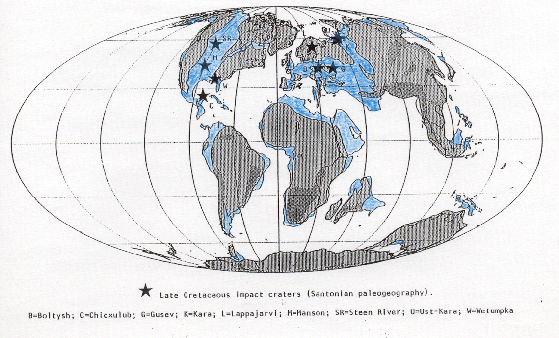
Figure 3 shows spatial distribution of Late Cretaceous impacts, continents, and epicontinental seas during Late Cretaceous (specifically Santonian; 85 Ma). Regional paleogeography shows that all nine Late Cretaceous impact craters (currently known and listed in Table 1) are located in Earth's northern hemisphere, and, further, all are boxed within an area approximately 40o latitude by 125o longitude. There is a bias towards discovery of northern-hemisphere impact craters mainly because there are higher levels of exploratory activities in most northern-hemisphere nations (Grieve and Shoemaker, 1994), but Late Cretaceous epicontinental sea distribution may have been a factor as well. However, total absence of Late Cretaceous southern-hemisphere impact craters is puzzling and not expected.
Writing on the topic of Aextraterrestrial impacts and mass extinctions of life,@ Rampino and Haggerty (1994) examine data from Sepkoski (1992) with respect to timing of peaks in percent extinction of marine genera per geologic stage. End-stage peaks for Late Cretaceous are described in Table 2 (complied from graphs in Rampino and Haggerty, 1994, and Rampino, 1994?). Extinctions correlated with Chicxulub are well documented and discussed in geological literature, therefore I will not dwell upon that extinction here (see Kring, 1993, for discussion). However, apparent connection between Steen River impact crater and a lesser mass extinction is somewhat surprising. Perhaps environmental effects from Steen River were keenly felt because it was an impact in the midst of the just-formed Western Interior Seaway, a vast epicontinental sea connecting the Gulf of Mexico and Arctic Ocean (Figure 3).
EPILOGUE
An unsurprising statement ends this report: The Wetumpka impact crater deserves further study and attention. At present, the Wetumpka impact crater seems unrelated to other impact or extinction events of note in the Late Cretaceous, but that conclusion could change. Clearly Wetumpka's impact was a devastating event for the local ecosystem and its biota when it happened. Its setting, both geological and paleogeographical may make Wetumpka exemplary for studying both (1) small complex craters developed in unconsolidated sediments resting on crystalline basement, and (2) small craters believed to have formed in shallow epicontinental seas.
We are living in a period of scientific revolution about cosmic influences upon Earth's past and the stratigraphical record. We are finding out that Earth's changing orbital parameters may have had much to do with periodic modulation of substantial climatic changes of the past. Also, we are finding that the old, discarded catastrophist notion about occasional and suddenly violent upheavals in Earth's ecosystems might actually be more correct than not, because we are recognizing many impact craters, much impact- crater ejecta, potentially great environmental effects from impacts, and strong correlation of impact cratering with mass extinctions. The eminent chemist, Harold C. Urey, envisioned the impact-extinction relationship long before we geologists and wrote a paper connecting Acometary collisions and geological periods@ that was far ahead of its time (Urey, 1973). He said stratigraphers would find impact-crater ejecta at boundaries of geological systems and lesser chronostratigraphic boundaries, and would thus come to appreciate the Avery great variation in climatic conditions ... and very violent physical effects@ caused by comet and asteroid impacts in geological history. It has taken us over a quarter of a century to catch up with Urey's thinking and begin to really appreciate and understand what influence Earth's impact record has had in the past and will have in the future.
I shall close on a quote from the late Derek V. Ager who has written so eloquently on the subject of rare events and their importance in geological history. In his last book, Ager (1993) wrote:
AMy thesis is that in all branches of geology there has been a return to ideas of rare violent happenings ... so the past, as now interpreted by many geologists, is not what it used to be. It has certainly changed a great deal from what I learned about in those far off days when I was a student.@
My initial interest in impact
craters and ballistic sedimentation was developed during my association
with Dr. Elbert A. King, Jr., (U. Houston) who gave me the opportunity
to work with ejecta regolith returned from the Moon while on a NASA fellowship
(1973-1975). Over the last 20 years I have kept in touch with this field
through many discussions with my friend Pete Banholzer (NASA-Goddard).
Recently, I have learned much from two most worthwhile Planetary
Society expeditions to study Chicxulub (KT-boundary) ejecta in both
Belize and Italy led by Drs. Adriana Ocampo (NASA-Washington), Kevin Pope
(GeoEcoArc), Al Fischer (USC), and Mike Rampino (NYU). Tony Neathery (Neathery
and Associates) kindly asked me to participate in a revisitation of the
Wetumpka impact crater and discussion of its implications for the 1997
southeastern section GSA meeting in Auburn, Alabama.
This web-page paper is an
edited version of one originally published in Alabama
Geological Society Guidebook 34C, The Wetumpka impact structure
and related features, edited by Thornton L. Neathery et al. (1997),
which is available from the Society
by writing to P.O. Box 866184, Tuscaloosa, AL 35486-0055 USA. The
proper citation for the original paper is as follows: King, D. T.,
Jr., 1997, The Wetumpka impact crater and the Late Cretaceous impact record:
in Neathery, T.L., D.T. King, Jr., and Lorraine W. Wolf, eds., The
Wetumpka impact crater and related features: Alabama Geological Society
Guidebook 34C, p. 25-56.
REFERENCES CITED
Aushkin, V.V., and Nemchinov, I.V., 1994, Consequences of impacts of cosmic bodies on the surface of the Earth: in Geherls, T., ed., Hazards due to comets and asteroids: Tucson, University of Arizona Press, p. 721-778.
Ager, D.V., 1993, The new catastrophism, the importance of the rare event in geological history: New York, Cambridge University Press, 231p.
Alvarez, W.A., Claeys, P., and Burns, E., 1993, A candidate KT boundary impact crater in Alabama [Abstract]: Eos (Transactions, American Geophysical Union), v. 74, p. 387.
Alvarez, W.A., Claeys, P., and Kieffer, S.W., 1995, Emplacement of Cretaceous-Tertiary boundary shocked quartz from Chicxulub crater: Science, v. 269, p. 930-935.
Bentley, R.D., Neathery, T.L., and Lines, G.C., 1970, A probable impact-type structure near Wetumpka, Alabama [Abstract]: Eos (Transactions, American Geophysical Union), v. 51, p. 342.
Bolt, B.A., 1993, Earthquakes: New York, W.H. Freeman and Company, 331p.
Chao, E.C.T., Hüttner, R., and Schmidt-Kaler, H., 1978, Principal exposures of the Reis meteorite crater in southeastern Germany. Description, photographic documentation and interpretation: München, Bayerisches Geologisches Landevant, 84p.
Frazier, W.J., 1979, Sedimentology and paleoenvironmental analysis of the Upper Cretaceous Tuscaloosa and Eutaw Formations in western Georgia: Georgia Geologic Survey, Information Series 53, p. 39-52.
Gault, D.E., Quaide, W.L., and Overbeck, V.E., 1968, Impact cratering mechanics and structures: in French, B.M., and Short, N.M., eds., Shock Metamorphism of Natural Materials: Baltimore, Mono Book Corporation, p. 87-99.
Glasstone, S., and Dolan, P.J., 1977, The effects of nuclear weapons, 3d ed.: Washington, D.C., United States Government Printing Office.
Gretener, P.E., 1967, Significance of the rare event in geology: American Association of Petroleum Geologists Bulletin, v. 51, p. 2197-2206.
Grieve, R.A.F., and Pesonen, L.J., 1992, The terrestrial impact cratering record: Tectonophysics, v. 216, p. 1-30.
Grieve, R.A.F., and Pilkington, M., 1995, The signature of terrestrial impacts: Journal of Australian Geology and Geophysics, v. 16, p. 399-420.
Grieve, R., Rupert, J., Smith, J., and Therriault, A., 1995, The record of terrestrial impact cratering: GSA Today, v. 5, p. 189 and 194-196.
Grieve, R.A.F., and Shoemaker, E.M., 1994, The record of past impacts on Earth: in Geherls, T., ed., Hazards due to comets and asteroids: Tucson, University of Arizona Press, p. 417-462.
Hall, J.C., 1996, Ground zero, the Wetumpka astrobleme: Alabama Heritage, Fall issue, p. 6-13.
Hills, J.G., Nemchinov, I.V., Popov, S.P., and Teterev, A.V., 1994, Tsunami generated by small asteroid impacts: in Geherls, T., ed., Hazards due to comets and asteroids: Tucson, University of Arizona Press, p. 779-789.
Hodge, P., 1994, Meteorite craters and impact structures of the Earth: New York, Cambridge University Press, 124p.
King, D.T., Jr., 1990, Upper Cretaceous limestone-marl sequences of Alabama: possible products of sea-level change not climate forcing: Geology, v. 18, p. 19-22.
King, D.T., Jr., 1994, Upper Cretaceous depositional sequences in the Alabama Gulf Coastal Plain: their characteristics, origin, and constituent clastic aquifers: Journal of Sedimentary Research, v. B64, p. 258-265.
King, D.T., Jr., and Skotnicki, M.C., 1994, Upper Cretaceous stratigraphy and sea-level history, Gulf Coastal Plain of central and eastern Alabama: Geological Society of America, Special Paper 287, p. 27-42.
King, E.A., Jr., 1976, Space geology: New York, Wiley and Sons, 349p.
Koeberl, C., 1994, African meteorite craters: characteristics and geological importance: Journal of African Earth Sciences, v. 18, p. 263-295.
Koeberl, C., and Anderson, R.R., 1996, Manson and company: impact structures in the United States: Geological Society of America, Special Paper 302, p. 1-30.
Kring, D.A., 1993, The Chicxulub impact and possible causes of K/T boundary extinctions: in Boaz, D., and Dornan, M., eds., Proceedings of the first annual symposium of fossils of Arizona: Mesa, Arizona, Mesa Southwest Museum and Southwest Paleontological Society, p. 63-79.
Melosh, H.J., 1989, Impact cratering. A geologic process: New York, Oxford University Press, 245p.
Morrison, D., Chapman, C.R., and Slovic, P., 1994, The impact hazard: in Geherls, T., ed., Hazards due to comets and asteroids: Tucson, University of Arizona Press, p. 59-92.
Neathery, T.L., 1983, Description (of Stops 15A, B, and C): in Carrington, T.C., ed., Current studies of Cretaceous formations in eastern Alabama and Columbus, Georgia: Alabama Geological Society, Guidebook 20, p. 48- 52.
Neathery, T.L., Bentley, R.D., and Lines, G.C., 1976, Cryptoexplosive structure near Wetumpka, Alabama: Geological Society of America Bulletin, v. 87, p. 567-573.
Rabinowitz, D.L., Bowell, E., Shoemaker, E.M., Muinonen, K., 1994, The population of Earth-crossing asteroids: in Geherls, T., ed., Hazards due to comets and asteroids: Tucson, University of Arizona Press, p. 285-312.
Rahe, J., Vanysek, V., and Weissman, P.R., 1994, Properties of cometary nuclei: in Geherls, T., ed., Hazards due to comets and asteroids: Tucson, University of Arizona Press, p. 597-634.
Rampino, M.R., 1994?, Impact cataclysms and the evolution of life: Science Spectra, v. ?, p. 40-43.
Rampino, M.R., and Haggerty, B.M., 1994, Extraterrestrial impacts and mass extinctions of life: in Geherls, T., ed., Hazards due to comets and asteroids: Tucson, University of Arizona Press, p. 827-858.
Read, W.A., 1984, Indian place names in Alabama: Tuscaloosa, University of Alabama Press, 107p.
Reinhardt, J., and Gibson, T.G., 1980, Field trip 20 road log. Upper Cretaceous-Lower Tertiary, Chattahoochee River valley: in Frey, R.W., ed., Excursions in southeastern geology, v. II: Falls Church, Virginia, American Geological Institute, p. 431-463.
Schindel, D.E., 1982, The gaps in the fossil record: Nature, v. 297, p. 282-284.
Schultz, P.H., and d'Hondt, S., 1996, Cretaceous-Tertiary (Chicxulub) impact angle and its consequences: Geology, v. 24, p. 963-967.
Sepkoski, J.J., Jr., 1992, A compendium of fossil marine families, 2d ed.: Milwaukee Public Museum Contribution to Biology and Geology No. 83.
Sharpton, V.L., Dressler, B.O., Herrick, R.R., Schnieders, B., and Scott, J., 1996, New constraints on the Slate Islands impact structure, Ontario, Canada: Geology, v. 24, p. 851-854.
Shoemaker, E.M., Wolfe, R.F., and Shoemaker, C.S., 1990, Asteroid and comet flux in the neighborhood of Earth: Geological Society of America, SpecialPaper 247, p. 155-170.
Skotnicki, M.C., 1985, Stratigraphy and depositional environments of the Upper Cretaceous Blufftown Formation, eastern Gulf Coastal plain of Alabama [unpublished M.S. thesis]: Auburn, Alabama, Auburn University, 149p.
Smith, A.G., Smith, D.G., and Funnell, B.M., 1994, Atlas of Mesozoic and Cenozoic coastlines: New York, Cambridge University Press, 99p.
Smith, E.A., Johnson, L.C., and Langdon, D.W., Jr., 1894, Report on the geology of the Coastal Plain of Alabama: Geological Survey of Alabama, Special Report 6, 759p.
Stose, G.W., ed., 1926, Geologic Map of Alabama: Geological Survey of Alabama, Special Map 7, scale 1:500,000.
Svehlak, H.T., and Sapp, C.D., 1972-3, State of Alabama uncontrolled ERTS-1 mosaic: Geological Survey of Alabama, Image 2.
Szabo, M.W., 1973, Phosphate resources of Perry County, Alabama: Geological Survey of Alabama, Circular 86, 24p.
Szabo, M.W., Osborne, W.E., Copeland, C.W., Jr., and Neathery, T.L., 1988, Geologic map of Alabama: Geological Survey of Alabama, Special Map 220, scale 1:250,000.
Thurmond, J.T., and Jones, D.E., 1981, Fossil vertebrates of Alabama: Tuscaloosa, University of Alabama Press, 242p.
Toon, O.B., Zahnle, K., Turco, R.P., and Covey, C., 1994, Environmental perturbations caused by impacts: in Geherls, T., ed., Hazards due to comets and asteroids: Tucson, University of Arizona Press, p. 791-827.
Urey, H.C., 1973, Cometary collisions and geological periods: Nature, v. 242, p. 32-33.
van Andel, T.H., 1981, Consider the completeness of the geological record:
Nature, v. 294, p. 397-398.
Zimbelman, J.R., 1997, Planetary geology: Geotimes, v. 42, no.
2, p. 23-24.
FIGURES AND TABLES
FIGURE 1.
Wetumpka impact-crater topography and generalized geology. Topography is
depicted by showing only 400 ft and 500 ft contour lines and shading areas
above 500 ft (152 m). Wetumpka's rim is shown clearly by an arcuate crystalline
piedmont ridge (msg) where most elevations above 400 ft (122 m)
are located. Crater interior is filled with an informally designated unit
called 'Wetumpka crater melange' (Kwcm) which contains two mapable
crystalline piedmont inliers near Hartwell Cemetery Hill (units labeled
mag and msg). These inliers are not part of Wetumpka's impact-crater
rim, and they may be part of Kwcm or, alternatively, may underlie
Kwcm. A north-south intra-crater drainage divide between dendritic
stream networks, shown by the 400 ft contour line, encompasses the impact-crater
peak at Hartwell Cemetery Hill. Undifferentiated Cretaceous strata (K)
surround the impact crater; Quaternary alluvium and high-terrace deposits
are not shown (see Figure 2A in Neathery et al., 1976). Topography
is from USGS Wetumpka 7.5-minute quadrangle; geology modified from Neathery
et al. (1976). Units mag (augen gneiss) and
msg (schist-gneiss)
from Neathery et al. (1976) are, respectively, Emuckfaw Group and
Kowaliga Gneiss of Szabo et al. (1988). On the index map, star with
a W locates Wetumpka's impact crater, but not to scale. [CLICK
HERE TO SEE FIGURE, THEN USE BACK BUTTON.]
FIGURE 2.
Paleogeographic reconstruction and regional setting of Wetumpka target
area during early Campanian (81.5 +/- 1.5 Ma). All features and relationships
are shown at approximately correct scale, including the impact crater diameter
(based upon data and references cited in King, 1994, and King and Skotnicki,
1994). Paleobathymetric contours are dashed lines; environments are labeled.
Wetumpka impact crater is at the star; Appalachian headland is in northeastern
map area. This figure, minus the impact site, can also be viewed in a generic
way because this paleogeographic scenario typifies central Alabama during
all the Late Cretaceous. When Late Cretaceous shifts in latitude and strike
of shoreline occurred, these changes attended rapid changes in relative
sea level (see discussion in King, 1994).
[CLICK HERE
TO SEE FIGURE, THEN USE BACK BUTTON.]
FIGURE 3.
Spatial distribution of Late Cretaceous impact craters (stars with identifying
letters) upon continents, shown here in an average Late Cretaceous paleogeographic
scenario. Note that all impact craters are in Earth's northern hemisphere,
and are within an area approximately 40o latitude by 125o
longitude. Eight of nine impact craters are clearly in epicontinental seas
(shaded blue). Light stipple represents lowlands; dark stipple, highlands.
Santonian (85 Ma) paleogeography is from Smith et al. (1994, their
Map 12); impact locations are plotted from data in Grieve et al.
(1995, their Table 1). Note that Kara (K) and Ust-Kara (U) form a doublet
crater; Ust-Kara=s center is
only 6 minutes of latitude north and 18 minutes of longitude east of Kara=s
center (Grieve
et al., 1995).
[CLICK HERE
TO SEE FIGURE, THEN USE BACK BUTTON.]
TABLE 1. Inventory of known Late Cretaceous impact craters in scientific literature, plus Wetumpka impact structure. [CLICK HERE TO SEE TABLES, THEN USE BACK BUTTON.]
TABLE
2. Relationship between stage-boundary extinction level and known
impact craters of same age. [CLICK
HERE TO SEE TABLES, THEN USE BACK BUTTON.]
DRILLING INTO THE WETUMPKA IMPACT
CRATER, ALABAMA
David T. King, Jr., Lucille W. Petruny, and Thornton
L. Neathery
Dept. Geology, Auburn University, Auburn, AL 36849; Neathery and
Associates, 1212-H 15th St. East, Tuscaloosa, AL 35404
[This article originally appeared in the May/June 1999 issue of VOYAGE! magazine.]
During several very hot weeks in June, July, and August, 1998, the authors were part of a team that completed the first scientific core drilling inside the Wetumpka impact crater, located near Wetumpka, a small city in central Alabama. The team consisted of ourselves, two drillers, and a geologist from Vulcan Materials Company of Birmingham, Alabama. The drilling was conducted by Vulcan as an in-kind gift to Auburn University following a successful scientific proposal submitted to them by David T. King, Jr. and Thornton L. Neathery.
Wetumpka impact crater is an unusual-looking geological feature that sits astride the boundary between Alabama=s Gulf coastal plain (a low-relief terrain covering the southern half of the state) and Appalachian piedmont (a moderate-relief terrain covering a significant part of central Alabama). Wetumpka has an unusual origin in that the point of impact was located in shallow marine water. Further, Wetumpka target material consisted of unconsolidated soft sediments overlying crystalline basement rock.
Wetumpka is remarkable in that its rim, made of crystalline basement rock is semi-circular, a shape thought to result from an oblique or low-angle impact along a northeast-to-southwest trajectory. The crater floor has topography that has been heavily dissected by stream erosion, but a rebound peak, typical of complex-type craters, is discernable at crater center. Wetumpka=s unusual geological features were first noted by reconnaissance mapping in 1891, but were not recognized as constituting an impact crater until completion during 1969-1972 of detailed geological mapping by a team headed by Thornton L. Neathery.
Wetumpka=s crater floor displays a crater fill comprised of a mixture of blocks ranging in size from several acres across to fist-size and smaller. This chaotic mix of target rocks was created within a few tens of seconds after impact due to release of a vast amount of explosive energy. Energy released due to detonation of the incoming asteroid is estimated to have been 1,500 megatons (a megaton is equal in explosive power to one million tons of TNT), or 15% of explosive power of the world=s Cold-War nuclear arsenal. Detonation at Wetumpka opened a crater that today is approximately 4 miles in diameter. Blast effect pulverized rock within a crater cavity that extends over 650 feet deep (beyond the limit of our drilling depth this past summer). Judging from crater diameter, we think that the Wetumpka asteroid diameter was approximately 1100 feet.
We have used relative age dating to determine an age of asteroid impact at Wetumpka. Specifically, by looking at age of the youngest rocks within Wetumpka=s crater fill, a relative age estimate can be made. The youngest rocks known in the crater fill have fossils in them which are thought to be approximately 80 to 83 million years old. In the absence of a more precise radiometric age date, we are using this date as presumed age of impact. Thus, Wetumpka=s age is probably 22 to 25 million years older than the Yucatan Peninsula=s huge crater at Chicxulub, directly across the Gulf of Mexico, and 6 to 9 million years older than the major crater at Manson, Iowa.
Drilling commenced on the morning of June 24, 1998, at drill-site number 1, which was located, we thought, as near to the center of Wetumpka impact crater as we could reach. (We were limited in places to drill on Wetumpka=s rebound peak because of property owner concerns, but outcrops in the selected area showed some impact breccia at the surface.) We soon discovered that drill-site number 1 was on the central rebound peak=s eastern flank and not exactly at its center. Being on the central peak=s flank caused us to have to drill through almost 327 feet of steeply inclined target strata comprising the flank before penetrating into several types of impactites, or crater-filling pulverized rock. Invaluable samples were recovered from our drilling operation in the form of continuous, 1.75-inch diameter cylindrical core.
The impactites in our drill cores displayed interbedded layers of (1) diamictites containing crystalline basement fragments brought up from great depth, (2) impact breccias (containing similar crystalline basement fragments), (3) huge blocks of target rock up to 35 feet thick, and (4) clay-rich sands. Diamictite is a rock that consists of broken pieces of target rocks in a matrix of finely pulverized rock. Impact breccia is a rock that consists of broken pieces of target rocks that generally lack finely pulverized matrix material. Both diamictite and impact breccia are common impactite rocks in the world=s crater-filling units. Huge blocks encountered in drilling were both pieces of deep crystalline basement rocks and chunks overlying softer sedimentary target rocks. Clay-rich sands appear to be a slurry formed from pulverization of the softer sedimentary-rock target material within the impact crater.
We drilled at site number 1 until July 10, 1998, when total depth of 638.5 feet was reached. The drilling at this site was very difficult due to relative softness of impactites and their abrasive characteristics. We averaged less than 50 feet/day, even though we were using Vulcan=s newest truck-mounted drilling equipment and their best drilling crew. Total depth was determined not by our reaching bottom of the crater fill, but by the fact that drilling progress became essentially nil at 638.5 feet due to poor down-hole conditions. After drilling ended, it took two days just to recover all drilling pipe from the ground.
We started drilling at drill-site number 2, located about 200 yards west of number 1, on July 15, 1998. Drilling continued at site number 2 until approximately August 4. A total depth of 589 feet was achieved, and drill-hole number 2 had to be abandoned prior to reaching bedrock beneath the crater for the same reasons as at drill-site number 1. The overlying steeply inclined sedimentary strata noted at drill-site number 1 were thinner at site number 2, being penetrated at a depth of 260.5 feet, and impactites were found below this depth. Diamictites, impact breccias, target-rock blocks, and clay-rich sands like those seen at drill-site number 1 were recovered in drill core from this drill hole. These drill cores display characteristics that have been described from drill cores taken at Manson crater (Iowa), Reis crater (Germany), and Ames crater (Oklahoma), and other craters.
Drilling at sites 1 and 2, both located upon the central rebound peak, was considered to be most significant from a scientific point of view because such a location would have experienced maximum possible impact pressure and other direct effects from asteroid impact. At present, we are conducting research to determine if shocked minerals were produced and are present at Wetumpka. Many craters have shocked quartz, but some notable craters do not, e.g., Upheaval Dome, Utah. It remains to be seen if we find shocked quartz, the best and most definitive proof of impact, but even if we do not, it is abundantly clear that Wetumpka is an impact crater (and a relatively well preserved one!).
CNN
came to drill-site number 1 and filmed a story that ran nationally on Headline
News during July 1-2, 1998. You can still find the internet story on this
(with embedded audio and video) by going to http://cnn.com/TECH/science/9807/17/t_t/alabama.crater/index.html.
You can learn more about Wetumpka by visiting: http://www.mindspring.com/~rwhigham/wetu.htm
or http://www.auburn.edu/academic/science_math/geology/docs/wetumpka/index.html
(for a virtual field trip).
EPILOGUE: In
January 1999, after submission of this story, we discovered shocked quartz
in several microscopic thin sections from drill hole number 1. In
February 1999, at a news conference in Wetumpka City Hall, we announced
discovery of shocked quartz from Wetumpka. Dr. Peter Schultz, Brown
University, participated in the news conference with us and reviewed evidence
confirming meteoritic impact with persons in attendance and with the press.
Presence of shocked quartz was also confirmed by Dr. Christian Keoberl,
Geochemistry Institute, University of Vienna (Austria). Working with
Dr. Willis Hames, Department of Geology, Auburn University, we have determined
subsequently that shocked quartz from Wetumpka shows two sets of shock
deformation lamellae. The nature of the lamellae indicates near-
instantaneous shock pressures in the range of at least 75,000 to 100,000
atmospheres. Further evidence of impact origin was announced in July
1999, when Dr. Christian Koeberl's analyses of samples taken from drill
hole number 1 showed a 20-times-normal enrichment of the element iridium.
This level of iridium almost certainly comes from the impacting body, likely
to have been a chondritic asteroid. Dr. Koeberl estimates that approximately
0.04% of the impacting body is imbued (at the molecular level) in the bedrock
at Wetumpka impact crater. This does not sound like much, but it
could amount to nearly 200,000 metric tons. Iridium, a non-toxic
element in low concentrations such as at Wetumpka, is very rare in most
terrestrial rocks, but is relatively common in meteorites, especially chondritic
meteorites. The combined presence of unequivocal shocked quartz and
iridium concentration at Wetumpka take the level of proof of impact to
the realm of 'beyond any reasonable doubt.'
CROSS-SECTION OF WETUMPKA IMPACT
CRATER, ALABAMA
David T. King, Jr. and Lucille W. Petruny
Dept. of Geology, Auburn University, Auburn, AL 36849 USA
[This article was originally published in Wetumpka Impact Crater Guidebook (1999).]
Completion of drilling into Wetumpka impact crater, Alabama, yielded geological information that allows us to make the first geological cross-section of the structure to scale (Figure 1).
The cross-section (Figure 1) is constructed along a northwest to southeast line, bearing north 55 degrees west, that includes Bald Knob on the northwest, and the drill sites on the central uplift in the center. Elevations are taken from the 1987 U.S.G.S. Wetumpka 7.5 minute topographic quadrangle map.
Drilling at drill hole number 1 reached total depth of 638.5 ft. The upper 85 ft was not cored, and that probably included unconsolidated Quaternary soil and alluvium. When coring commenced at 85 ft, the drill was cutting into target Upper Cretaceous strata that displayed varying dips of up to 45 degrees. At 288.5 ft, the drill penetrated into impactite sands, a sediment type peculiar to the crater fill that represents a mixture of various target sand layers. Below 326.8 ft, we encountered four major rock types interbedded with impactite sand. These rock types were: shocked impact breccia, unshocked impact breccia, mica schist blocks, and target sedimentary rock blocks. At total depth, the drill was still cutting into impactite sands, therefore we did not reach the >bottom= of the crater.
Drilling at drill hole number 2 reached total depth of 589.0 ft. The upper 240 ft were not cored, and that probably included unconsolidated Quaternary soil and alluvium, as before. When coring commenced at 240 ft, the drill was cutting into impactite sands. Below 260.5 ft, the drill penetrated into the first impact breccia and thereafter cored material consisted of interbedded impactite sands and the four rock types noted previously. At total depth, the drill was still cutting into impact breccia, therefore, as before, we did not reach the >bottom= of the crater.
Figure 1 shows the inferred relations between rock units within the Wetumpka impact crater fill. Upper crater-filling unit is an highly deformed layer of Upper Cretaceous target strata that is approximately 200 ft thick in the central region of the impact crater. The lower crater-filling unit is impactite sands with interbedded deposits of shocked and unshocked impact breccia and target rock blocks. The position of the crater >bottom= is inferred from drilling results, and may be deeper than shown. Figure 1 indicates notable surface outcrop features, including slump-block deposits on inside of the northwest rim, and small outcrops of impactite sands with impact breccia on the central rebound peak.
Figure
Figure 1. Geological and topographical cross-section of Wetumpka impact crater according to the latest discoveries. Drawn to scales stated on side and below. Vertical exaggeration is 12.5x.
Addendum
The proper reference for this article is King, D.T., Jr. and L.W. Petruny, 1999, Cross-section of Wetumpka impact crater, Alabama, in King, D.T., Jr. and L.W. Petruny, eds., Wetumpka impact crater guidebook: Auburn, Alabama, 29p. [CLICK TO LEARN HOW TO ORDER THIS GUIDEBOOK.]
Glossary
alluvium - sand and gravel deposits of ancient streams
disturbed sedimentary strata - layers of sediments and sedimentary rock that have been formed by the force of impact
impactite facies - mixture of impactite sands and shocked impact breccia
impactite sands - sand deposits inside an impact crater that form by various processes which mix sands from the target material together in a slurry
mica schist - metamorphic rock (bedrock in this area) that is mineralogially layered (foliated) and is rich in mica
rebound peak - central uplifted area of an impact crater
sedimentary rock - rock that consists of fragments of other rocks compacted and cemented together
schist and gneiss - two types of metamorphic rock that are very common in the local bedrock at Wetumpka
shocked impact breccia - a breccia (rock made of angular fragments of other rock) that forms in an impact crater and contains significant shocked materials, especially shocked quartz
slump block - a large cohesive block of material that falls downslope due to gravitational instability; this likely happens in impact craters on the walls after the crater forms
target rock - rock that is in and around the point of impact and becomes involved in the impact event and its aftermath
Quaternary - a geological period beginning 1.64 million years ago and encompassing the modern Aice ages@
unshocked impact breccia - impact breccia (see shocked impact breccia) that does not contain significant shocked material
Upper Cretaceous - adjectives used to refer to rock that formed during Late Cretaceous, a time interval from 88.5 to 65.0 million years ago
**********
THE NEEDLE IN THE HAYSTACK:
SHOCKED QUARTZ FROM WETUMPKA
IMPACT CRATER, ALABAMA
David T. King, Jr., Willis E. Hames, and Lucille
W. Petruny
Dept. of Geology, Auburn University, Auburn, AL 36849 USA
[This article was originally published in Wetumpka Impact Crater Guidebook (1999).]
The mineral quartz, where it contains parallel, microscopic planar deformation structures (or PDFs), is referred to as Ashocked quartz.@ Seeking shocked quartz is the Aone of the most widely applied criteria for recognizing impact structures@ according to Bevan M. French, one of the original researchers in this area of mineralogy (French, 1999). In his recent monograph, titled Traces of Catastrophe, French (1999), he recounts over 30 years of work on this topic and current understanding of the significance of shocked quartz in impact-produced and related materials. His work reinforces the notion that shocked quartz is likely the best and most unequivocal of criteria for recognition of terrestrial impact structures.
Not all impact craters contain shocked quartz, but all shocked quartz has been found in impact craters, except for small amounts noted in rocks of craters produced by detonation of nuclear weapons. Whereas there are many criteria for recognition of impact craters, shocked quartz stands out the best and most widely accepted of all. The reasons for this lie in the commonness of quartz itself (the second most common mineral on Earth), and the fact that quartz PDFs apparently form at modest shock pressures, pressures most likely to be found even in relatively small impact craters.
The kinetic energy of an impact event, KE, is equal to 0.5mv2 , where m is the mass of the asteroid or comet and v is its velocity. Velocities of incoming asteroids and comets can range from a few km/sec up to approximately 72 km/sec, but 20 km/sec would be a reasonable average (Rahe et al., 1994). Squaring such velocities and multiplying a mass that may be in the range of 100 million metric tons or more (e.g., Wetumpka asteroid was likely 50 million metric tons or more) yields some very large numbers for kinetic energy. Explosive energies of asteroid and comet impacts are thus measured in terms of many tens, hundreds, or even thousands of megatons of TNT.
Shock pressures generated by such explosions are measured in Gigapascals (GPa), and one Gpa is equal to 10 Kilobars (kbar) or about 10,000 atmospheres. Relatively small impacts (but large enough to make a simple impact crater) or impacts that are more nearly Aglancing blows,@ seem to have shock pressures in the range of 2 to 6 GPa (or 20,000 to 60,000 atmospheres). Very large impact craters, e.g. the 200 km diameter crater near Sudbury, Ontario, might have rocks that experienced shock pressures of 100 GPa or more.
In Traces of Catastrophe, French (1999) compiles data on the particular crystallographic orientation and number of PDFs in order to rank these in terms of estimated shock pressure. According to French, PDFs with an orientation like those seen in Wetumpka samples (Figure 1) begin to emerge at shock pressures in the range of 7.5 to 10 GPa (or 75,000 to 100,000 atmospheres). From this we infer that such shock pressures are the minimum experienced at Wetumpka. We may subsequently discover that actual shock pressures were higher.
Figure
Figure 1. Shocked quartz from Wetumpka. Very fine sand grain from Wetumpka impact crater (drill hole number 1) mounted on a needle and viewed with plain light under microscope. Grain has been slightly etched with hydrofloric acid to enhance the shock-produced planar deformation features (PDFs). The PDFs look like thin, parallel lines running across the crystal. There are two sets of these PDFs (one can be seen on each side of the grain). The long axis of the quartz crystal, c, is indicated, and the angle of the PDF, labeled gamma, is shown in relation to c. This angle is also indicative of PDFs developed at the inferred shock pressure mentioned above. The PDF itself represents permanent intracrystal damage due to the passage of a hypervelocity shock wave generated in the impact event. No other known natural process produces this kind of intracrystal damage, which results from near instantaneous application of pressure. Photograph by Willis E. Hames. [CLICK ON LINK ABOVE FOR LARGER IMAGE.]

References
French, B.M., 1999, Traces of catastrophe: Houston, Texas, Lunar and Planetary Institute Contribution Number 954, 120p. [CLICK FOR INFORMATION.]
Rahe, J., Vanysek, V., and Weissman, P.R., 1994, Properties of cometary nuclei: in Geherls, T., ed., Hazards due to comets and asteroids: Tucson, University of Arizona Press, p. 597-634.
Addendum
The source publication for this article and the preceding article on this web page, i.e., Wetumpka impact crater guidebook, can be obtained by writing to David T. King, Jr. at the address above. A copy can also be obtained by making a tax-deductable contribution to the Wetumpka Impact Crater Fund at Auburn University (see details below).
The proper reference for
this article is King, D.T., Jr. W.E. Hames, and L.W. Petruny, 1999, The
needle in the haystack: shocked quartz from Wetumpka impact crater,
Alabama, in King, D.T., Jr. and L.W. Petruny, eds., Wetumpka
impact crater guidebook: Auburn, Alabama, 29p.
EVIDENCE CONFIRMING METEORITIC IMPACT AT WETUMPKA CRATER, ALABAMA, U.S.A.
David T. King,
Jr., Thornton L. Neathery, Lucille W. Petruny, Christian Koeberl, and Willis
E. Hames
Dept. of Geology, Auburn University, Auburn, AL
36849 USA
Neathery and Associates, 1212-H 15th Street East, Tuscaloosa,
AL 35404 USA
Dept. of Geology, Auburn University, Auburn, AL 36849
USA
Geochemistry Institute, University of Vienna, Althanstrasse
14, Vienna, Austria
Dept. of Geology, Auburn University, Auburn, AL 36849
USA
[This 1999 abstract was originally published in Meteoritics and Planetary Science, v. 34-Suppl., p. A63-64.]
Introduction: Wetumpka impact crater, located in Elmore County, Alabama, USA (N32o 31.5=, W86o 10.5=), is a prominent 6.5 km diameter semi-circular, rimmed structure, which formed in a target consisting of essentially unconsolidated sedimentary units overlying crystalline basement rock. At time of formation, estimated at 80 to 83 m.y. ago, this target was covered by up to 100 m of seawater as the area was part of a Late Cretaceous continental shelf [1,2]. Crater shape (semi-circular, open on southwest quadrant) suggests oblique impact [3] on a southwesterly trajectory [2]. Wetumpka has total gravity relief of 10 mGal [4] and maximum magnetic relief of 0.015 Gauss [5].
Target stratigraphy: In this region, three soft Upper Cretaceous units lie unconformably upon crystalline pre-Cretaceous Appalachian bedrock. In age order, they are: Tuscaloosa Group (60 m); Eutaw Formation (30 m); and Mooreville Chalk (30 m) [3].
Surface geology: Surficial crater geology consists of two main terrains: (1) a heavily weathered, semi-circular rim composed of Appalachian piedmont bedrock, which has up to 87 m modern relief, and (2) a highly dissected crater floor composed of contiguous tracts of slightly to highly disturbed target strata (consisting of Tuscaloosa Group and minor but significant irregularly shaped tracts of Eutaw Formation and Mooreville Chalk) [3]. Only one, small outcrop of impactite facies, which encompasses an area of a few hundred square meters, occurs within this crater. This centrally located outcrop coincides with a topographic high, which may represent Wetumpka=s rebound peak.
Subsurface geology: All three stratigraphic units mentioned previously plus crystalline bedrock were involved in this impact event and contributed clastic material to Wetumpka=s subsurface impactoclastic crater-filling unit [6]. Core drilling at Wetumpka=s crater center reveals that disturbed target strata are only 64 m thick and that over 130 m of impactite facies occur below that level [6]. In Wetumpka=s subsurface crater-filling unit, impactite facies, consisting of impactite sands and monomict and polymict impact breccias, are intercalated with 1 to 5 m-thick blocks of target strata and crystalline basement [6].
Petrography: Polymict breccias are comprised of crystalline bedrock clasts and cataclastic matrix. In thin section, cataclastic matrix contains fine-sand sized shocked-quartz grains. These grains display two sets of PDFs, which appear to indicate shock pressures toward the lower end of the 8 to 25 GPa range. Impact-related planar microstructures are also present in plagioclase and micas within polymict breccia matrix.
Geochemistry: Results of gamma-gamma coincidence spectrometry indicate that some of Wetumpka=s impactite beccias have a relatively high iridium component of approximately 200 ppt. Other analytical techniques indicate that Co and Au are also relatively highly concentrated in impactite breccias (as much as 119 and 800 ppm, respectively).
Conclusion: Owing to initial studies done over 25 yr ago [3], Wetumpka impact structure has been described as a Aprobable impact crater@ on some crater lists. Now, we are reporting shocked quartz, siderophile element concentrations, and impactites, which provide key evidence both supporting and confirming meteoritic impact at Wetumpka.
References: [1] King, Jr. D. T. et al. (1997) Alabama Geol. Soc. Guidebk., 34c, 25-56. [2] King, Jr. D. T. and Neathery T. L. (1998) Amer. Assoc. Petrol. Geol. Ann. Conv. Abst., 7, 358a-f. [3] Neathery T. L. et al. (1976) Geol. Soc. Amer. Bull., 87, 567-573. [4] Wolf L. W. et al. (1997) Alabama Geol. Soc. Guidebk., 34c, 57-68. [5] Neathery T. L. et al. (1997) Alabama Geol. Soc. Guidebk., 34c, 1-23. [6] King, Jr. D. T. et al. (1999) LPS XXX, 1634.
Acknowledgments: Drilling at Wetumpka was an in-kind gift to Auburn University from Vulcan Materials Company, Birmingham, Alabama, USA.
Post-publication addendum:
This is an edited and revised version of an abstract presented at the 62nd
Meteoritical Society meeting in Johannesburg, S.A., in July 1999.
Presentation of this work represented the first public announcement of
shocked quartz and iridium at Wetumpka given at a scientific meeting.
LATE CRETACEOUS SHALLOW-SHELF
IMPACT IN GULF COASTAL PLAIN OF ALABAMA
David T. King, Jr., Thornton L. Neathery, and Lucille
W. Petruny
Dept. Geology, Auburn University, Auburn, AL 36849
Neathery and Associates, 1212-H 15th St. East, Tuscaloosa, AL 35404
Dept. of Curriculum and Teaching, Auburn University, Auburn, AL
36849
[This 2001 abstract was published in Geological Society of America Abstracts for the Field Forum on Impact in Wet Targets.]
Wetumpka impact structure in Alabama (6 km diameter) was formed in a shallow shelfal environment, probably in water less than 100 m deep and within a few tens of kilometer of the coeval shoreline.
Sub-bottom target stratigraphy included three uncompacted Upper Cretaceous sediment layers (total of about 100 m) and underlying, hard crystalline pre-Cretaceous basement rocks. Therefore, this impact involved three layers of very different properties: a sea-water layer (relatively thin compared to the impacting body=s size); a substantially thick, stratified and water-saturated target sediment; and an very hard bedrock basement layer.
These conditions produced a crater that has some special aspects, including a bowl-shape (i.e., not a typical terraced, complex crater form), an uplifted, semi-circular, hard crystalline rim; and a distinctive, crater-filling Aresurge@ unit that also partially surrounds the impact structure. Deeply eroded but well-preserved, Wetumpka shows us some additional important external features perhaps common to such shallow shelfal craters, including Abeveling@ of adjacent, non-target strata and evidence of Aresurge channel@ incision, which has been filled with Upper Cretaceous chalky marl sediment. Wetumpka illustrates how Aenvironment of cratering@ has substantial effects upon crater morphology and impact-related stratigraphy within and outside a crater.
Wetumpka also possesses some special characteristics that are probably related to its marine origin and that we do not fully understand yet. For example, Wetumpka lacks melt-rock or Asuevite.@ Further, Wetumpka crater-filling sediment contains much more finely divided carbonaceous material and larger pieces of lignitic material than any of its known target units. Thus, provenance of this organic material is unclear. Finally, shocked material is relatively rare at Wetumpka. Only minor layers of polymict impact breccia recovered in drill cores of crater filling unit contain shocked quartz. Shocked quartz content in such breccias is commonly under 10 grains per cubic cm. The whole of Wetumpka=s crater-filling unit appears to be a giant, catastrophic sedimentary deposit of complex origin that we have been referring to, for lack of a better term, as an Aimpact melange.@
Post-publication addendum: This is an abstract of an invited oral presentation made in April 2001 at the Geological Society of America sponsored Field Forum in Las Vegas, Nevada. This work summarizes our current thinking about oceanic impact at Wetumpka. A recent paper by Jens Ormo and Maurits Lindstrom summarizes best the sequence of events when an asteroid or comet strikes in marine waters. The attached figure is from Ormo's paper and is a good model for what we think happened at Wetumpka. Readers are encouraged to see this publication. Citation of Ormo and Lindstrom's paper is given below.
Ormo, J., and
M. Lindstrom, 2000, When a cosmic impact strikes the sea bed:
Geological Magazine, v. 137, p. 67-80.
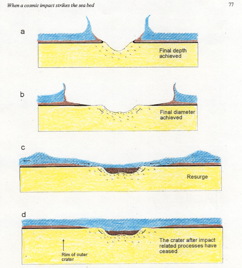