 Click
here for larger version.
Click
here for larger version.
David T. King, Jr.
Department of Geology, Auburn University
CONTENTS
I. Cretaceous-Tertiary Boundary Stratigraphy near San Antonio, Orange Walk District, Belize, Central America [CLICK]
II. Cayo District Cretaceous-Tertiary boundary stratigraphy, Belize [CLICK]
III. Stratigraphy and sedimentology of Cretaceous-Tertiary boundary deposits in Belize, Central America [CLICK]
IV. Astrostratigraphic units - some proposed nomenclature
for terrestrial impact-derived and impact-related units [CLICK]
* * * * * * * * * * * * * * * * * * * * * * * * *
* * * * * * * * * * * * * * * * * * * * * * * * * * * * * * * * * * * *
* * * * * * * * * * * * * * * * * * * * *
Cretaceous-Tertiary Boundary Stratigraphy near San
Antonio, Orange Walk District, Belize, Central America
David T. King, Jr.
Department of Geology, Auburn University, Auburn, AL 36849-5305
USA
[This article is an edited and expanded version of one published in Gulf Coast Association of Geological Societies Transactions, v. 46 (1996), p. 213-217.]
ABSTRACT
In Albion Quarry near the town of San Antonio, Orange Walk District, Belize, an extremely coarse carbonate-dominated diamictite with basal spheroid-bearing clay layer, totaling 16-m thick, is situated directly above the Maastrichtian Barton Creek Dolomite. The diamictite is a direct ejecta deposit, itself 14-m thick, comprised of debris ranging from clay-size to 8-m diameter boulders. The diamictite represents a terrestrial debris-flow or base-surge deposit from the 300-km diameter Chicxulub impact crater situated in adjacent Yucatan Province, Mexico.
INTRODUCTION
In northern Belize, the Cretaceous-Tertiary boundary consists of a thick blanket of ejecta material deposited almost immediately after impact of an very large diameter asteroid or comet at Chicxulub in the adjacent Yucatan Province, Mexico (Pope et al., 1991; Ocampo et al., 1996). This impact and its global consequences, including related mass extinctions, are commonly viewed as the apocalyptic terminal Cretaceous scenario. With the exception of some breccias in adjacent parts of the state of Quintana Roo, Mexico (i.e., on the west side of Rio Hondo, across from Albion Island), exposures in Belize are the most proximal known ejecta deposits directly associated with the now-buried Chicxulub crater.
The original diameter of the crater itself is thought to have been approximately 300 km, and the crater looks like a multi-ringed basin (Sharpton et al., 1996). The Chicxulub basin is believed to have been created by a comet or asteroid having a 10- to 20-km diameter (Pope et al., 1994). The estimated energy release upon impact is equivalent to 114 x 106 Mton TNT (Alvarez et al., 1995).
Exposures in Albion Quarry, are approximately 315 km, or just over one crater diameter, from the crater center (Figure 1). This position is within the theoretical limit for continuous ejecta and secondary impact cratering as calculated by Melosh (1989) for a 300-km diameter crater (Pope, 1994). Mass- acceleration calculations indicate that the velocity of debris-flow movement leaving the crater rim would have been on average approximately 300 m/sec (Overbeck, 1975), making the debris-flow arrival time in northern Belize just over 9 minutes after impact.
The Cretaceous-Tertiary boundary stratigraphy in Belize has several special aspects owing to its proximity to the Chicxulub crater rim. First, with a thickness of approximately 16 m, it is likely one of the thickest known outcropping Cretaceous-Tertiary boundary section in the world. Further, the boundary section is the only known direct ejecta deposit (a terrestrial to very shallow-marine, debris-flow or base-surge deposit) yet described. Also, the ejecta in Belize contains the largest fragments (8-m diameter boulders) yet described from beyond the Chicxulub crater rim. Belize ejecta is also notable for its lack of 1) shocked quartz (and other shocked framework silicates), 2) iridium-bearing sediments, and 3) true tektites (although irregular clay clasts in the diamictite from the northern Belize show evidence of formerly being glass; Ocampo et al., 1996). Ejecta-thickness measurements at Albion Quarry are in accord with scaling-law prediction at 350 km from crater center (Kring, 1993).
STRATIGRAPHY
Cretaceous-Tertiary boundary stratigraphy in the San Antonio area, Orange Walk District, Belize encompasses the Maastrichtian Barton Creek Dolomite and overlying boundary diamictite layer with basal spheroid bed. The upper contact with Paleocene rocks was not observed in outcrop during this study but may occur in the Maya Mountain foothills and in central Belize near Belmopan (Cornec, 1986). In two subsurface borings, 15 and 26 kilometers south of Albion Quarry, overlying Paleocene carbonates are noted above a "limestone-clay-shale" unit corresponding to the diamictite (Pope, 1994). Paleocene carbonates consist of the Doubloon Bank Group in northern Belize (Orange Walk District) and the El Cayo Group in central Belize near Belmopan and in the Maya Mountain foothills (Cayo District; Cornec, 1985, 1986).
Barton Creek Dolomite
Maastrichtian Barton Creek Dolomite of northern Belize is a medium-grey to light-tan relatively finely crystalline dolomite representing several original limestone types including lime mudstone, wackestone, packstone, and grainstone. At Albion Quarry, the Barton Creek consists of cyclically arranged groupings, approximately 5-m thick, each comprised of two main lithic types (or facies). The upper facies in each cycle consists of 8- to 15-cm thick beds of planar cross-stratified, relatively coarsely crystalline dolomitic packstone and grainstone. Within coarsely crystalline dolostones near the top of some cycles, voids (vugs) several centimeters across suggest a former presence of nodular evaporite minerals. The lower facies in each cycle consists of several 3- to 5-cm thick beds of dolomitic wackestone and mudstone.
Barton Creek is largely devoid of substantially intact macrofossils; the few that occur are typically moldic voids in dolostone. Abundant microfossils, especially foraminifera, were present in original sediment, but now are mainly moldic voids or ghosts in dolostone.
Age of Barton Creek is established by rare Maastrichtian carcineretid crabs (Carcineretes woolacotti) and rare Campanian-Maastrichtian nerineid gastropods (Ocampo, 1995). The latest Maastrichtian age is also confirmed by 87Sr/86Sr ratios from samples of the uppermost stratum that match inferred global sea-water compositions in carbonate rocks dated between 67 and 64 Ma (Ocampo et al., 1996). Terminal Cretaceous dates of 65.0, 66.4, and 66.5 Ma are generally assigned by various authors.
The upper surface of the Barton Creek is irregular owing to microkarst development. Microkarst features, including pits and pipes, are related to late Maastrichtian subaerial exposure and solution weathering. Ejecta fills microkarst features on the former Maastrichtian land surface. Ocampo et al. (1996) have suggested that an initial vapor plume stripped away any soil present as the basal spheroid bed is in direct contact with the Barton Creek bedrock.
Basal Spheroid Bed
The spheroid bed in Albion Quarry is a separate basal unit (Figure 2; Figure 3), 1- to 2-m thick, comprised of brown to rust-colored clay, containing oblate, pebble-size dolomitic spheroids (Figure 4) and green or red clay clasts. This basal spheroid bed has distinctively sharp, lower and upper boundaries and sharply defined, inclined clay glide planes within it. The base of the spheroid bed is a paper-thin hematitic rind on the dolomitic microkarst; the top of the spheroid bed is a hard slickenside surface. Spheroids and clay clasts are flattened near the base of the bed and become more nearly equidimensional near the top. Ocampo et al. (1995;1196) have conducted isotopic and petrographic analyses of the spheroids and clay clasts and demonstrated that the spheroids are high-temperature, vapor-phase condensates and clay clasts are likely altered glass fragments.
Diamictite Layer
At Albion Quarry, the diamictite is approximately 14-m thick and contains at least 5 beds (considering the composite of AQ3 and AQ4, Figure 2). Each of these individual beds range from 1- to 8-m thick (Figure 5). Bed thickness within the diamictite varies over several hundred meters. Individual beds appear to pinch and swell and cannot be correlated directly unless the contact is directly traceable between outcrops (e.g., see correlation of AQ1 and AQ2, 2 m apart, versus AQ2 and AQ3, 10 m apart; Figure 2). Bases and tops of beds are relatively sharp, but do not show convincing evidence of any erosion between depositional events. Bedding within the diamictite was delineated by slope breaks, changes in clast size and composition, changes in sorting or clast density, and changes in matrix composition.
Generally, the whole diamictite layer has a distinctive very coarse texture and very poor sorting. Grain size ranges from boulders (-13.5 f) to clay-size (+13.5 f). Beds consist of an approximately equal mix of 1) matrix (including clasts up to pebble-size) and 2) clasts (cobble and boulder-size).
Within individual beds, crude grading (with floating boulder-size clasts near the bed top) is common (Figure 2). As part of the crude grading, boulders located at the base of some beds show imbrication and clast-support. Isolated boulders also occur at the basal surfaces of beds; these large clasts are not commonly oriented with their long axes parallel to bedding. Crude grading may be the result of fluidization in the flow and floating clasts may result from displacive pressure when fluidization is lost (Prothero and Schwab, 1996).
Other internal sedimentary structures of the diamictite are crude flow lamination in matrix located within 1 to 2 m of the bed top (Figure 2; Figure 6). These structures are interpreted to represent the effects of laminar flow in the inertial deposit.
In Albion Quarry, the matrix is mainly tan to light grey highly comminuted dolomite in clay-silt size range. This matrix contains a component of small pebble-size red and green clay clasts (Figure 7), especially common near the base, and a component of tan fine-grained dolostone clasts up to pebble size throughout. Ocampo et al. (1996) have interpreted the clay clasts as altered glass fragments.
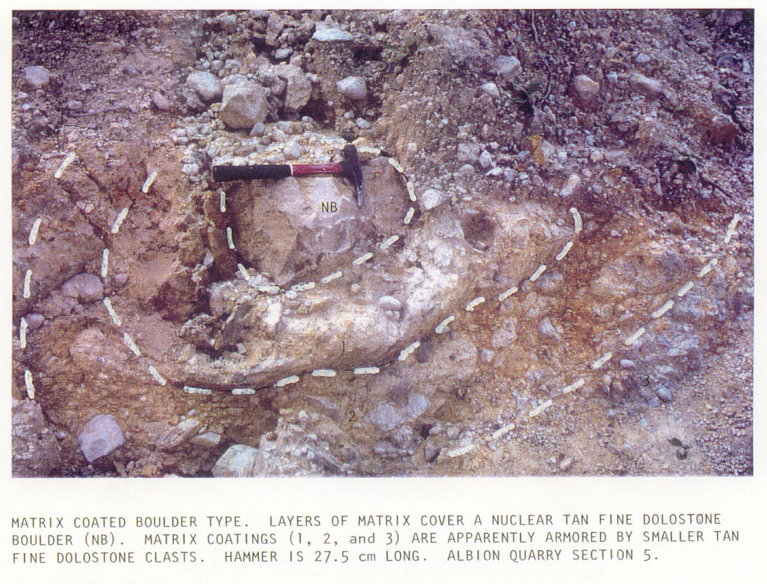
Cobble- and boulder-size clasts are commonly dense, tan dolostone lithologically resembling the previously described, finely crystalline facies of the underlying Barton Creek. Boulders over 1 m across are commonly angular; boulders over 2 m across commonly display internal bedding. A second type of boulder-size clast, 1 to 3 m across, displays matrix coating in concentric armored layers (Figure 8). The nucleus of such matrix-coated boulders is commonly a tan finely crystalline dolostone clast (Figure 8).
Cobbles and boulders under 20 cm in diameter are commonly rounded and bear percussion marks, dendritically branching abrasions and striations (Figure 9), and rare internal hinge fractures (compare with illustrations in Rampino, 1994).
The diamictite has a nonintact, matrix-supported framework (Figure 10) generally throughout, thus classifying it as a paraconglomerate or parabreccia (Prothero and Schwab, 1996). The apparent common, local source for all dolomite clasts larger than pebbles qualifies the diamictite as an oligomict paraconglomerate or parabreccia (i.e., a tilloid; Prothero and Schwab, 1996). However, the unusual texture of the diamictite precludes it from being easily classified according to existing schemes.
DISCUSSION
Diamictite in Belize is like direct ejecta from other craters in carbonate terrain, notably the 15-Myr old Ries Crater ejecta in Germany, in that high percents of both the matrix and large clasts are locally derived (Horz and Banholzer, 1980). However, the diamictite in Belize lacks significant amounts of glass and glass byproducts and is internally bedded, among other significant differences with Ries ejecta.
Bedding in Belizan ejecta diamictite is particularly interesting because it suggests that different parts of the ejecta flow were moving at slightly different speeds or took slightly different flow paths. Further, it is possible that the layers were deposited at significantly different times or originated at different points. The similarity of sedimentary structures and textures within beds suggests that common processes were operative within each sedimentological unit during emplacement. It is unclear at this time what role secondary impacts may have had in rearranging diamictite stratigraphy, but such impacts may help explain bedding characteristics.
CONCLUSIONS
Cretaceous-Tertiary boundary stratigraphy varies globally according to geographic proximity to the Chicxulub impact crater, mode of transportation of debris (including launch angle and launch velocity), environment of deposition, and extent of post-depositional reworking (Alvarez et al., 1995). The boundary deposits include: 1) iridium-enriched clay layers, a few centimeters thick (atmospheric fireball deposits); 2) microtektite and spherule deposits, less than 1-m thick (ejecta- curtain and ballistic sedimentation layers); 3) scour-based conglomerates and sandstones and marine-slump deposits, several meters thick (tsunami- and wave-reworked strata and shock-wave induced deposits); and 4) direct-ejecta or base-surge units (terrestrial debris-flow deposits; Alvarez et al., 1995; Ocampo et al., 1996). The latter deposits are rarest in outcrop and are exemplified by 16-m thick ejecta deposit in Belize.
As we learn more about the stratigraphy and sedimentology of direct ejecta, such as the diamictite described above, we will learn more about the processes of terrestrial cratering and impact sedimentation. Hopefully, future work in Belize will help us learn to better recognize impact-generated diamictites in the stratigraphic record and assess their implications.
ACKNOWLEDGMENTS
I thank the original researchers of Albion Quarry, Adriana C. Ocampo (JPL, Washington) and Kevin O. Pope (GeoEcoArch Research), for generously showing the Albion Quarry exposures to me and others during their 1996 Planetary Society expedition to Belize. Extensive pioneering work on the K/T boundary in Belize has been done by Adriana and Kevin (as indicated by the numerous citations of their work above; see especially Ocampo et al., 1996), and I deeply appreciate their generously sharing so many discoveries and ideas thus allowing me to make a few additional observations.
The proper citation of this web paper is its original paper form, which is given in the reference King (1996b) below. Please note that some figures have been added to this web version and some figures are different from the original published paper. All photographs are by David T. King, Jr.
EPILOGUE
In 1996, I was asked to summarize stratigraphic data from central Belize (Cayo District), which was gathered principally by me during the Planetary Society expedition. A highly generalized version of this synthesis appeared in July/August issue of Planetary Report (King, 1996a) accompanying several other articles by expedition members. Later in 1996, I completed a 15-page manuscript titled "Cretaceous-Tertiary boundary stratigraphy in Belize, Central America," which summarized observations made in northern and central Belize by me and the Planetary Society group during our expedition. Ultimately, this manuscript was not published in its entirety, but its abstract was published (King et al., 1996) and relevant detailed correlations were presented at the 1996 Geological Society of America Annual Meeting in Denver. At that meeting, four papers were presented during a poster session on the Planetary Society group's expedition results from earlier that year. Abstracts of these papers appeared together in the 1996 Annual Meeting's Abstracts with Programs (Pope et al., 1996; Ocampo et al., 1996; King et al., 1996; Rampino et al., 1996). Further, there is general information about the 1996 expedition on the Planetary Society web page (http://planetary.org).
In 1998, the Planetary Society group again visited Belize to study sites visited in 1996 and other sites. A paper summarizing some of these new results was published in Earth and Planetary Science Letters (Pope et al., 1999). Adriana Ocampo, Kevin Pope, and colleagues have continued to work on Belize Cretaceous-Tertiary boundary stratigraphy in the interim and recently published new interpretations regarding high-altitude ejecta in the Cayo District of central Belize (Pope and Ocampo, 2000) and new findings regarding ejecta "facies" within the Belizian boundary unit (Ocampo et al., 2001). There is general information about the 1998 expedition on the Planetary Society web page (http://planetary.org).
In 2000, Lucille Petruny and I conducted reconnaissance work in Belize and made grain-size frequency measurements in the diamictite at Albion Quarry. The Albion grain-size data are summarized in the 2000 Annual Meeting Abstracts with Programs of the Geological Society of America (Petruny and King, 2000) and within a summary paper prepared for a Cuban e-journal, Earth and Spatial Sciences (King and Petruny, 2001).
In 2001, the Planetary Society group returned to Belize to study sites at Albion Quarry, and adjacent areas in Quintana Roo, Mexico, and in central and western Belize. It is likely that several papers will come out of this work. There is a daily log of activities from this expedition posted on the Planetary Society web page (http://planetary.org).
REFERENCES CITED
Alvarez, W., P. Claeys, and S.W. Keiffer, 1995, Emplacement of Cretaceous-Tertiary boundary shocked quartz from Chicxulub crater: Science, v. 269, p. 930-935.
Cornec, J.H., 1985, Note on the provisional geological map of Belize at the scale 1:250,000: Belmopan, Belize, Petroleum Office, 22 p.
Cornec, J.H. 1986, Provisional geologic map of Belize: Belmopan, Belize, Petroleum Office.
Horz, F., and G.S. Banholzer, Jr., 1980, Deep seated target material in the continuous ejecta deposits of the Ries Crater, Germany, in J.J. Papike and R.B. Merrill, eds., Proceedings of the conference on the lunar highlands crust: New York, Pergamon Press, p. 211-231.
King, D.T., Jr., 1996a, Stratigraphy: layers of evidence (Belize): Planetary Report, v. 16, p. 10-11. [reproduced below]
King, D.T., Jr., 1996b, Cretaceous-Tertiary boundary stratigraphy near San Antonio, Orange Walk District, Belize, Central America: Gulf Coast Association of Geological Societies Transactions, v. 46, p. 213-217.
King, D.T., Jr., A.G. Fischer, A.C. Ocampo, K.O. Pope, and M.R. Rampino, 1996, Stratigraphy and sedimentology of Chicxulub ejecta deposits from northern and central Belize, Central America: Geological Society of America Annual Meeting Abstracts with Programs, v. 28, no. 7, p. A-182.
King, D.T., Jr., and L.W. Petruny, 2001, Stratigraphy and sedimentology of Cretaceous-Tertiary boundary deposits in Belize, Central America: Earth and Spatial Sciences (in press).
Kring, D.A., The Chicxulub impact event and possible causes of K/T boundary extinctions, in D. Boaz and M. Dornan, eds., Proceedings of the First Annual Symposium of Fossils of Arizona: Mesa, Arizona, Mesa Southwest Museum and Southwest Paleontological Society, p. 63-79.
Melosh, H.J., 1989, Impact cratering: A geologic process: New York, Oxford University Press, 245 p.
Ocampo, A.C. , 1995, Journey to the end of the dinosaur era: A society expedition to Belize: Planetary Report, v. 15, p. 10-14.
Ocampo, A.C., K.O. Pope, and A.G. Fischer, 1996, Ejecta blanket deposits of the Chicxulub crater from Albion Island, Belize: Geological Society of America Special Paper 307, p. 75-88.
Ocampo, A.C., K.O. Pope, A.G. Fischer, and J. Morrison, 1995, Evidence in Belize for ballistic and vapor-plume sedimentation from the Chicxulub impact: Geological Society of America Annual Meeting Abstracts with Programs, v. 27, no. 6, p. A-347.
Ocampo, A.C., K.O. Pope, A.G. Fischer, J. Morrison, and five others, 1996, Belize K/T boundary deposits: Relation to Chicxulub impact: Geological Society of America Annual Meeting Abstracts with Programs, v. 28, no. 7, p. A-182.
Ocampo, A.C., K.O. Pope, F. Vega, and B.W. Fouke, 2000, Depositional facies of the Chicxulub ejecta blanket in southern Yucatan Peninsula: Eos, Transactions of the American Geophysical Union, v. 81, no. 48, p,. F798.
Overbeck, V.R., 1975, The role of ballistic erosion and sedimentation in lunar stratigraphy: Review of Geophysics and Space Physics, v. 13, p. 337-362.
Petruny, L.W., and D.T. King, Jr., 2000, Grain-size frequency distributions of Cretaceous-Tertiary boundary breccia deposits in Belize, Central America: Geological Society of America Annual Meeting Abstracts with Programs, v. 32, no. 7, p. A-451-452.
Pope, K.O., 1994, Biospheric effects of a large extraterrestrial impact: Case study of the Cretaceous/Tertiary boundary crater: FY 1993 Progress Report/NASA Contract No. NASW-4812 (Exobiology Program), La Canada, CA, GeoEcoArch Research, 21p.
Pope, K.O., K.H. Baines, A.C. Ocampo, and B.A. Ivanov, 1994, Impact winter and the Cretaceous/Tertiary extinctions: Results of a Chicxulub asteroid impact model: Earth and Planetary Science Letters, v. 128, p. 719-725.
Pope, K.O., and A.C. Ocampo, 2000, Chicxulub high-altitude ballistic ejecta from central Belize: Lunar and Planetary Science, v. 31, abstract number 1419.
Pope, K.O., A.C. Ocampo, and C.E. Duller, 1991, Mexican site for K/T impact crater?: Nature, v. 351, p. 105.
Pope, K.O., A.C. Ocampo, and A.G. Fischer, 1996, Proximal Chicxulub impact ejecta: Depositional processes inferred from physical models and surface exposures: Geological Society of America Annual Meeting Abstracts with Programs, v. 28, no. 7, p. A-182.
Pope, K.O., A.C. Ocampo, A.G. Fischer, W. Alvarez, and six others, 1999, Chicxulub impact ejecta from Albion Island, Belize: Earth and Planetary Science Letters, v. 170, 351-364.
Prothero, D.R., and F. Schwab, 1996, Sedimentary geology: New York, W. H. Freeman, 575 p.
Rampino, M.R., 1994, Tillites, diamictites, and ballistic ejecta of large impacts: Journal of Geology, v. 102, p. 439-456.
Rampino, M.R., and six others, 1996, Characteristics of clasts in K/T debris-flow diamictites in Belize compared with other known proximal ejecta deposits: Geological Society of America Annual Meeting Abstracts with Programs, v. 28, no. 7, p. A-182.
Sharpton, V.L., and seven others, 1996, A model of the Chicxulub impact basin based on evaluation of geophysical data, well logs, and drill core samples: Geological Society of America Special Paper 307, p. 75-88.
FIGURES
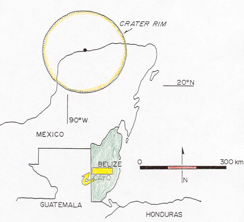
Figure 1. Location map showing the Yucatan penninsula of Mexico. Chicxulub crater rim and the study site at Albion Quarry (AQ) are indicated.
Click
here for larger version.
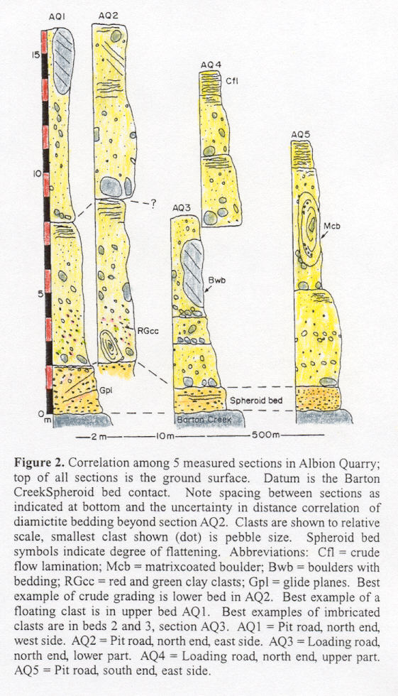
Figure 2. Correlation among 5 measured sections in Albion Quarry; top of all sections is the ground surface. Datum is the Barton Creek-Spheroid bed contact. Note spacing between sections as indicated at bottom and the uncertainty in distance correlation of diamictite bedding beyond section AQ2. Clasts are shown to relative scale, smallest clast shown (dot) is pebble size. Spheroid bed symbols indicate degree of flattening. Abbreviations: Cfl = crude flow lamination; Mcb = matrix-coated boulder; Bwb = boulders with bedding; RGcc = red and green clay clasts; Gpl = glide planes. Best example of crude grading is lower bed in AQ2. Best example of a floating clast is in upper bed AQ1. Best examples of imbricated clasts are in beds 2 and 3, section AQ3. AQ1 = Pit road, north end, west side. AQ2 = Pit road, north end, east side. AQ3 = Loading road, north end, lower part. AQ4 = Loading road, north end, upper part. AQ5 = Pit road, south end, east side.
 Click
here for larger version.
Click
here for larger version.
Figure 3. Stratigraphy of the basal part of the Cretaceous-Tertiary boundary layer in Albion Quarry. Upper and lower contacts of the spheroid bed are indicated by dotted lines.
 Click
here for larger version.
Click
here for larger version.
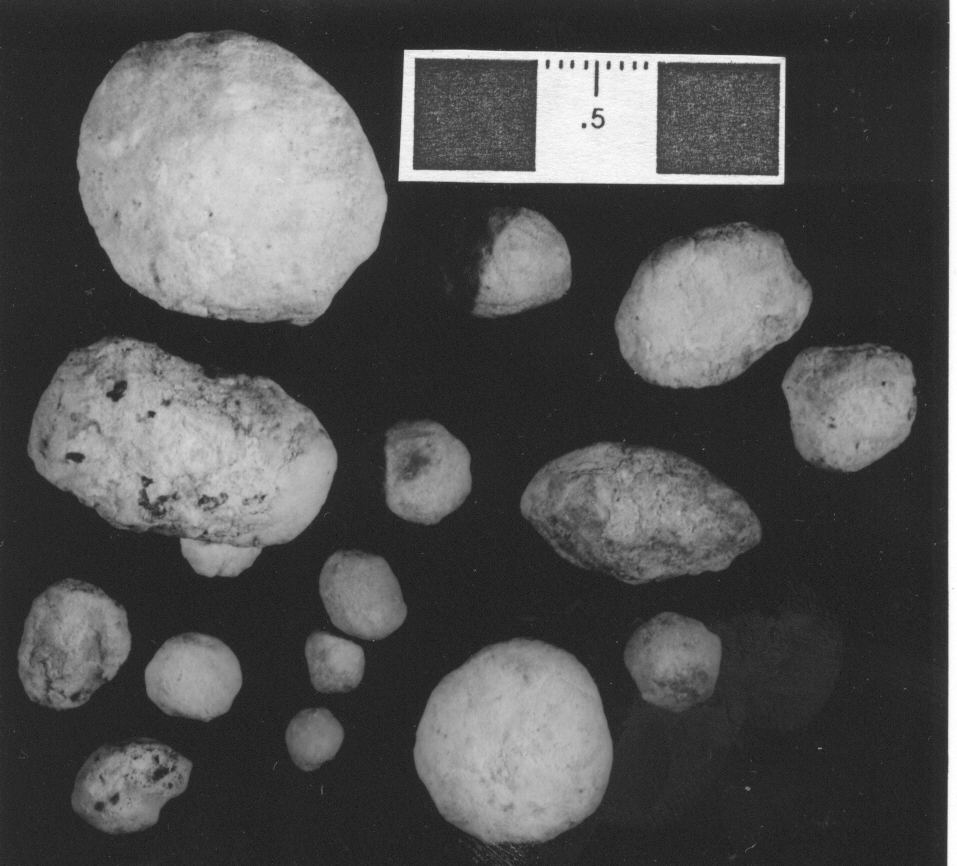
Figure 4. Dolomitic spherules from the upper half of the spheroid bed. Section AQ1. Scale is 3 centimeters.
 Click
here for larger version.
Click
here for larger version.
Figure 5. Bedding and boulder locations within the diamictite at Albion Quarry. Contacts are traced on photograph with dashed lines and boulders are outlined.
 Click
here for larger version.
Click
here for larger version.
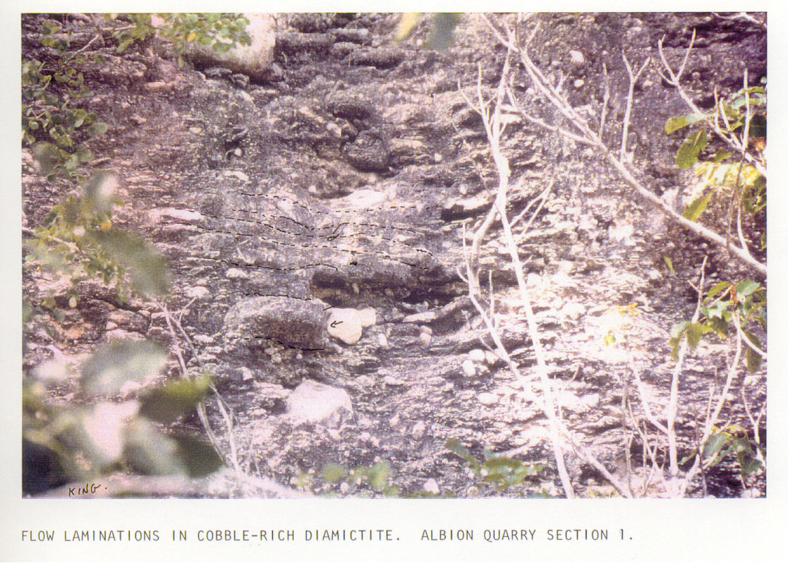
Figure 6. Flow laminations on weathered surface of diamictite. Area pictured is near the top of the upper layer, section 1, Albion Quarry.
 Click
here for larger version.
Click
here for larger version.
Figure 7. Former green glass shards (now green clay with relict vessicles) from basal one meter of diamictite, section 2, Albion Quarry.
 Click
here for larger version.
Click
here for larger version.
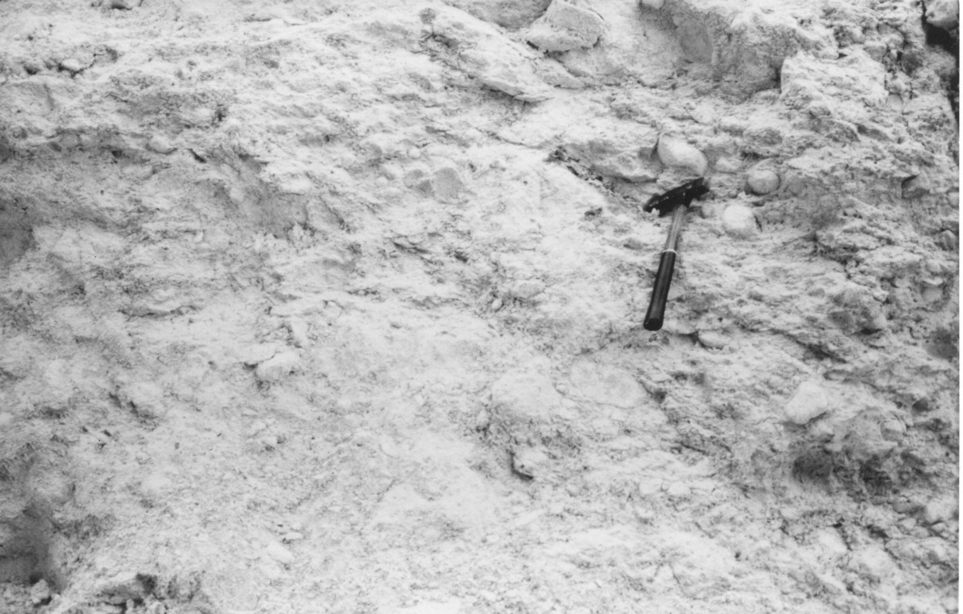
Figure 8. Diamictite displaying part of a 1.5-m diameter matrix-coated boulder. The hammer rests on an angular, tan finely crystalline dolostone clast. Section AQ5, lower bed, west side. Hammer = 12.5 cm.
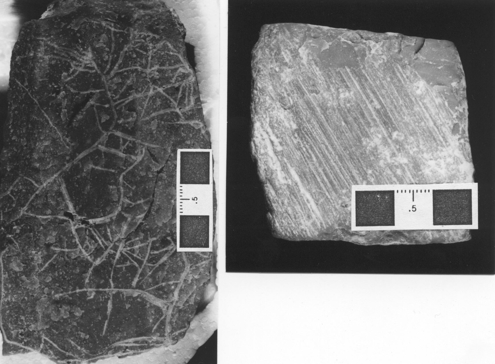
Figure 9. Cobbles with dendritically branching abrasions (left) and striations (right). Section AQ1, lower bed. Scale is 3 centimeters.
 Click
here for larger version.
Click
here for larger version.
Figure 10. Diamictite displaying overall poor sorting and coarse texture. Section AQ2, upper bed. Hammer = 12.5 cm.
 Click
here for larger version.
Click
here for larger version.
Click here
for an enhanced black and white version.
* * * * * * * * * * * * * * * * * * * * * * * * *
* * * * * * * * * * * * * * * * * * * * * * * * * * * * * * * * * * * *
* * * * * * * * * * * * * * * * * * * * *
Cayo District Cretaceous-Tertiary boundary stratigraphy,
Belize
David T. King, Jr.
Department of Geology, Auburn University, Auburn, AL 36849-5305
USA
[This article is an edited and expanded version of one published in Planetary Report, v. 16 (1996), p. 10-11.]
In the foothills of the Maya Mountains, and in the Cayo District of central Belize near Belmopan, the capital of Belize, a sedimentary layer approximately 30 m thick comprises the Cretaceous-Tertiary (KT) boundary. This layer is the apparent lateral equivalent of the ejecta formation described previously from Albion Island in northern Belize (i.e., the Albion formation; Ocampo et al., 1996).
Whatever the mechanism for emplacement of this unit, or the exact sequence of events, it is startling to imagine how such a thick blanket of rock debris could be laid down over such a vast area -- Yucatan Peninsula and adjacent parts of Central America -- in such a brief span of time. Calculations show that Chicxulub's debris flow could have moved at 300 m/sec (Overbeck, 1975). Thus, its arrival time in Belize was likely only about 10 minutes after impact. These energetic flows may have much in common with fluidzed ejecta flows observed on Mars (Pope et al., 1996).
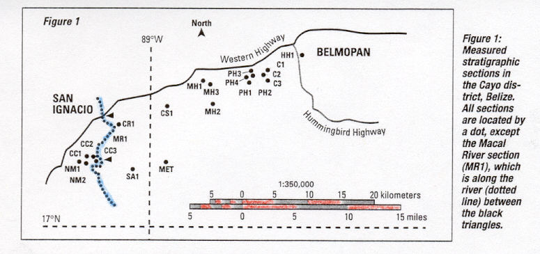
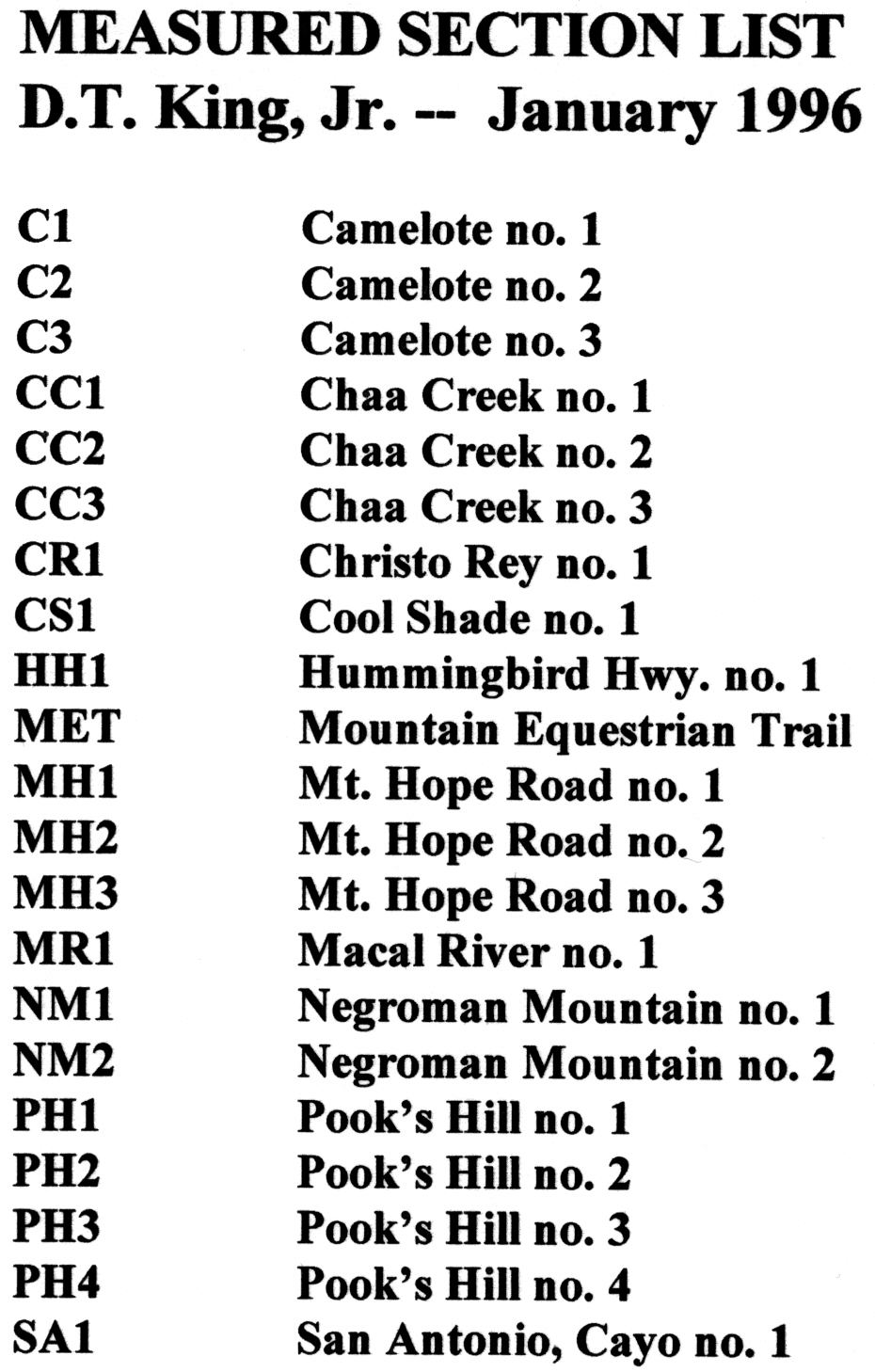
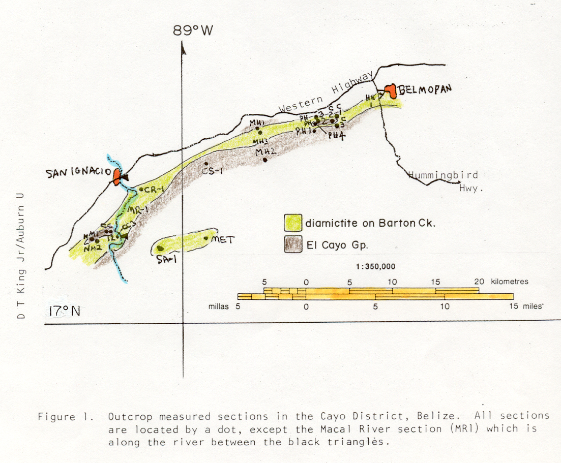
Few locales on Earth afford the opportunity to study such massive, rapidly deposited bodies of rock. The layer examined lies between Upper Cretaceous Barton Creek dolostone and the overlying Lower Tertiary El Cayo Group limestones. To study this boundary layer, we measured 21 stratigraphic sections (Figure 1) to determine the nature and sequence of rock layers. Thirteen measured sections spanned the ejecta layer.
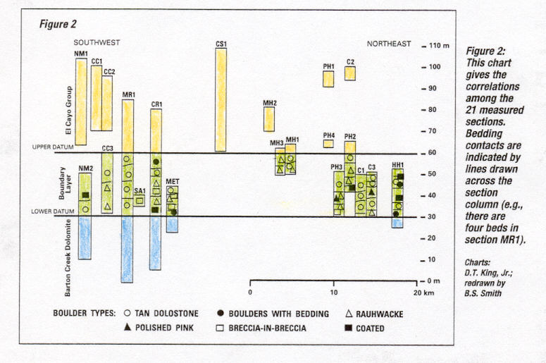
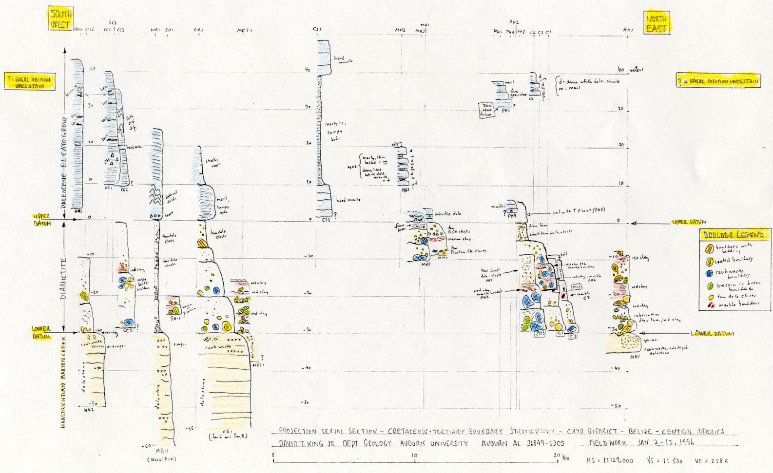
To gain an internal view of this layer, a serial section correlation diagram was constructed among all 21 sections (Figure 2). A glance at the correlation show that individual beds appear in all the stratigraphic sections. There are as few as five to perhaps as many as 10 beds in any given part of the boundary layer.
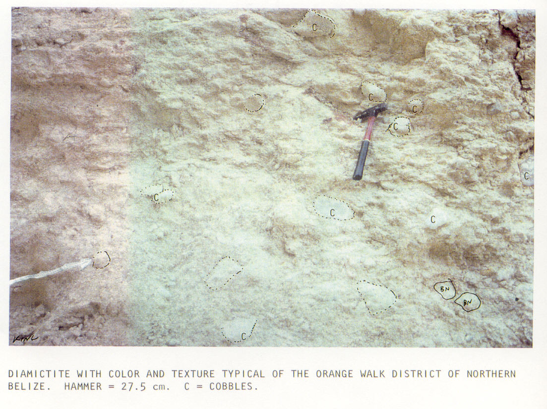
Each bed has both common and distinctive characteristics. Beds range from 3 to 10 meters thick, and their thickness can vary along a single outcrop. Material making up these beds, from finely ground matrix to boulders 8 meters across, are very poorly sorted. Many of the beds show evidence of flow lamination, i.e., thin parallel layers of sediment formed by laminar flow conditions (rather than turbulent flow conditions) in their upper third. In the Cayo District, diamictite matrix tends to be red or red-brown with angular tan dolomitic clasts (Figure 3).
Six main types of boulders were found in diamictite of the Cayo District: tan dolostone boulders; boulders with bedding; matrix-coated boulders; rauhwacke (or "rough-rock") boulders of highly weathered dolostones; breccia-in-breccia boulders; and polished pink carbonate boulders (King et al., 1996). The first five types could have come from the local Upper Cretaceous bedrock. The polished pink "marble-like" boulders (Fischer, 1996; Ocampo et al., 1996) do not seem to have an equivalent bedrock type in Belize. It is thought that they may have taken a sub-orbital trajectory from Chicxulub to this locale.
Several preliminary conclusions are suggested by these data, although clearly additional study is indicated. First, the textures and sedimentary structures within each bed are consistent with some type of debris-flow deposit (King, 1996b). Second, the similarities of materials within boundary layers in central Belize suggest that a common process formed each. Third, constituent strata suggest that separate layers of debris flow were 1) moving at different speeds, 2) following independent paths, 3) deposited at slightly different times, and/or 4) generated from different locations.
All this makes certain that
whatever happened after bolide impact, materials were distributed along
yet-to-be-understood paths to their terminal resting places in Belize.
It is also possible that secondary impacts of huge blocks ejected from
Chicxulub crater played a role in determining the final stratigraphy of
the ejecta layer. Such large blocks may have rained down on Belize in a
sort of "carpet bombing" scenario. This could help explain why debris-flow
deposits potentially contain significant local bedrock and why they may
appear to have come from different directions at slightly different times.
FIGURES
Figure 1. Geographic distribution of measured stratigraphic sections in Cayo District, Belize. All sections are located by a dot except the Macal River section (MR1), which follows part of the river's course (between black triangles).
To see the location of this rectangular area within the Cayo District
of Belize, CLICK HERE.
To see an inventory of measured sections listed on this map, CLICK
HERE.
To see a geological map of this area showing the KT boundary unit outcrop
and measured section locations, CLICK HERE.
Figure 2. Simplified correlation among 21 measured sections. Bedding contacts are indicated by lines drawn across the section column (e.g., there are four beds in section MR1). Boulder types and their distribution are indicated by symbols (see key).
To see an inventory of measured sections listed on this correlation,
CLICK HERE.
To see the original, larger version of this correlation, CLICK
HERE.
Figure 3. Cayo District diamictite in a typical exposure that has been scraped clean. This outcrop is part of Christo Rey no. 1 section.
EPILOGUE
After the original version of this Planetary Report article (King, 1996a) was published, a more technical version was presented in an abstract by King et al. (1996). Subsequently, the diamictite of central Belize was informally named "Teakettle diamictite" by Pope and Ocampo (2000), who favor an interpretation that this diamictite unit is mainly "regolith from the weathered Cretaceous surface" rather than being strictly ejecta as in northern Belize. Later work (Ocampo et al., 2000) suggested that several different ejecta "facies" may be recognizable in central and western Belize.
In an accompanying Planetary Report article by Fischer (1996), the unusual, pink "marble-like" boulders found in the Cayo District were referred to as "Pook's pebbles" for the first time (PICTURE). Subsequent study of Pook's pebbles by Pope and Ocampo (2000) summarized evidence that these are likely far-traveled ejecta (i.e., terrestrial carbonate 'meteorites') that may have experienced plastic deformation (with impact cratering and gouging) and ablation (with development of an ablation crusts) upon re-entry. They point to peculiar to fine striations within the surficial high polish as key evidence in their interpretation (cf. Chao, 1976). At this time, the exact origin of these unusual objects is still unclear.
REFERENCES
Chao, E.C.T., 1976, Mineral-produced high-pressure striae and clay polish: Key evidence of non-ballistic transport of ejecta from Ries crater: Science, v. 194, p. 615-618.
Fischer, A.G., 1996, Mineralogy: carved in stone: Planetary Report, v. 16, p. 8-9.
King, D.T., Jr., 1996b, Cretaceous-Tertiary boundary stratigraphy near San Antonio, Orange Walk District, Belize, Central America: Gulf Coast Association of Geological Societies Transactions, v. 46, p. 213-217. [reproduced above]
King, D.T., Jr., 1996a, Stratigraphy: layers of evidence: Planetary Report, v. 16, p. 10-11.
King, D.T., Jr., A.G. Fischer, A.C. Ocampo, K.O. Pope, and M.R. Rampino, 1996, Stratigraphy and sedimentology of Chicxulub ejecta deposits from northern and central Belize, Central America: Geological Society of America Annual Meeting Abstracts with Programs, v. 28, no. 7, p. A-182.
Pope, K.O., and A.C. Ocampo, 2000, Chicxulub high-altitude ballistic ejecta from central Belize: Lunar and Planetary Science, v. 31, abstract number 1419.
Pope, K.O., A.C. Ocampo, and A.G. Fischer, 1996, Proximal Chicxulub impact ejecta: Depositional processes inferred from physical models and surface exposures: Geological Society of America Annual Meeting Abstracts with Programs, v. 28, no. 7, p. A-182.
Ocampo, A.C., K.O. Pope, and A.G. Fischer, 1996, Ejecta blanket deposits
of the Chicxulub crater from Albion Island, Belize: Geological Society
of America
Special Paper 307, p. 75-88.
Ocampo, A.C., K.O. Pope, A.G. Fischer, J. Morrison, and five others, 1996, Belize K/T boundary deposits: Relation to Chicxulub impact: Geological Society of America Annual Meeting Abstracts with Programs, v. 28, no. 7, p. A-182.
Ocampo, A.C., K.O. Pope, F. Vega, and B.W. Fouke, 2000, Depositional facies of the Chicxulub ejecta blanket in southern Yucatan Peninsula: Eos, Transactions of the American Geophysical Union, v. 81, no. 48, p,. F798.
Overbeck, V.R., 1975, The role of ballistic erosion and sedimentation
in lunar stratigraphy:
Review of Geophysics and Space Physics, v.
13, p. 337-362.
* * * * * * * * * * * * * * * * * * * * * * * * *
* * * * * * * * * * * * * * * * * * * * * * * * * * * * * * * * * * * *
* * * * * * * * * * * * * * * * * * * * *
Stratigraphy and Sedimentology of Cretaceous-Tertiary
Boundary Breccia
Deposits in Belize, Central America
David T. King, Jr. and Lucille W. Petruny
Department of Geology, Auburn University, Auburn, Alabama 36849
USA
[This paper is an edited and expanded version of one published in the Cuban e-journal, Earth and Spatial Sciences (2001).]
ABSTRACT
At Albion Island, in northern Belize, Cretaceous-Tertiary (KT) boundary deposits, a.k.a. Albion formation, rest upon intensively fractured Maastrichtian dolostones and consist of a basal, spheroid-bearing clay layer (< 1 m thick) and an upper impact-related carbonate-clast breccia (or "diamictite") up to 15 m thick. Albion's diamictite, the focus of this paper, shows crude stratification (2 to 7 m thick) containing intrastratal structures like flow laminations and size grading. Most of Albion's carbonate clasts show a broad range of angularities and shapes, with the most common being subangular and compact-bladed to compact-elongated, respectively. We made in-situ, apparent-diameter measurements of diamictite carbonate clasts, which ranged in size from 10 to 300 mm (or -3.3 to -8.2 f). Matrix, the total area comprised of less-than-10 mm (-3.3 f) particles, ranged from 50 to 70 percent. Cumulative grain-size (f) frequency curves, with probability ordinate, displaying Albion's grain sizes have consistent, distinctive shapes displaying slope breaks near -4 f and -7 f, which may signify a potentially complex origin for this unit. Bedding characteristics and sedimentary structures combined with grain-size frequency analysis suggest to us that multiple events delivered diamictite material of impact-related origin to this region. These multiple events are likely related to sequential stages in the collapse of Chicxulub's ejecta curtain and/or phases of interaction between that ejecta curtain and Earth's atmosphere.
INTRODUCTION
In northern Belize and in closely adjacent areas of the state of Quintana Roo, Mexico, a discontinuous layer of carbonate breccia (or diamictite) lies between Maastrictian dolomites and Paleocene limestones. This breccia unit, known locally as the Albion formation (Pope et al., 1999), represents terrestrial ejecta deposits from Chicxulub impact crater, which is centered 300 to 350 km away in the state of Yucatan, Mexico (Sharpton et al., 1996). Ocampo et al. (1996) marshaled much evidence strongly favoring interpretation of Albion Formation and laterally equivalent breccias as coeval ejecta units of Chicxulub, and theirs is the current working hypothesis for origin of these materials.
The Albion formation consists at least three distinctive members, including basal spheroid-bearing clay layer, a diamictite unit, and a bed that is rich in highly polished pebbles (called Pook's pebbles, hence the informal name Pook's pebble bed; Ocampo et al., 2000). Albion formation, as developed at Albion Island, Belize (and exposed within Albion Quarry near San Antonio) also extends into adjacent parts of the Mexican state of Quintana Roo. In this vicinity, Albion formation consists of the basal spheroid-bearing clay layer and overlying diamictite bed (Pope et al., 1999) and ranges from 8 to 15 m thick. Less than 50 km away, in central Belize, this formation is a few meters thick and consists of the basal spheroid-bearing clay layer and overlying Pook's pebble bed, apparently without intervening diamictites (Ocampo et al., 2000). Both Pope et al. (1999) and Ocampo et al. (2000) have suggested different mechanisms of emplacement for the three constituent Albion facies in order to account for their stratigraphic and geographic occurrence. Specifically, they interpret the spheroid-bearing clay bed as having formed directly upon the karsted and fractured Maastrichtain land surface by action of a very hot, rapidly expanding vapor cloud. They interpret overlying diamictites as secondary, ballistic sediments principally formed from a more slowly moving, volatile-rich vapor cloud associated with the collapsing ejecta curtain. They note that the diamictites seem limited to a distance of approximately 360 km (or 4 crater radii) from crater center, and beyond this limit they pinch out. Lastly, they interpret the Pook's pebble bed as lofty high-velocity ejecta originating mainly from shallow target rock material, which fell in Belize mainly beyond the limit of the diamictite.
The focus of this paper is upon the Albion's diamictite bed in northern Belize and what stratigraphy and sedimentology of that diamictite can tell us about possible emplacement processes for this diamictite. Various mechanisms have been proposed for development of the diamictite (reviewed by Pope et al., 1999), and thus our goal is to add basic knowledge of this unit and its attributes and to comment on possible processes of emplacement based upon our data. Our work was conducted at Albion Quarry (Figure 1), located on Albion Island, near San Antonio in the Orange Walk District, Belize.
STRATIGRAPHY
Cretaceous-Tertiary boundary stratigraphy on Albion Island and vicinity consists of the Maastrictian Barton Creek Formation and overlying Cretaceous-Tertiary boundary deposits (i.e., basal spheroid-bearing clay layer and overlying diamictite), which are capped by an erosional surface and modern soils. A direct upper contact with Paleocene rocks was not observed on Albion Island, but occurs 30 km farther south in the Cayo District of central Belize (King, 1996a), and in adjacent Quintana Roo, Mexico (M.A. Gibson, personal communication). Cornec (1985; 1986) also describes an apparent contact between Cretaceous-Tertiary boundary deposits and Paleocene rocks in the northern foothills of the Maya Mountains.
Barton Creek Formation
Maastrichtian Barton Creek Formation, a formal stratigraphic unit of northern Belize, is a thick sequence of tan to medium gray, dolomitized shallow-water carbonates. On Albion Island, Barton Creek beds consist of cyclically arranged groupings of strata, approximately 5 m thick, each comprised of two main lithic types (or facies). In each cycle, the upper facies consists of 8 to 15 cm thick beds of planar, cross-stratified, relatively coarsely crystalline dolomitic packstone and grainstone. Within coarsely crystalline dolostones near the top of some cycles, voids (vugs) several centimeters across suggest the former presence of nodular evaporite minerals. The lower facies in each cycle consists of several 3 to 5 cm thick beds of dolomitic wackestone and packstone.
Barton Creek is largely devoid of substantially intact macrofossils, and the few that may be discerned are typically moldic voids in dolostone. Abundant microfossils, especially foraminifers, were present in original sediment texture, but are now reduced to fine moldic voids or textural ghosts in the rock.
Age of the Barton Creek is established by two relatively rare, but key macrofossils: a Maastrichtian carcineretid crab (Carcineretes planetarius Vega) and a nerineid gastropod with infolding wall structures (Vega et al., 1997; Pope et al., 1999). As reported in Ocampo et al. (1996), late Maastrictian age of upper Barton Creek is supported by 87Sr/86Sr rations ranging from 0.70786 to 0.70796.
The upper surface of Barton Creek outcrops on Albion Island is highly irregular, including solution pits and pipes (probably related to Late Cretaceous subaerial exposure and solution weathering) and deep fractures (probably related to impact-generated ground motion from the Cretaceous-Tertiary bolide event). Pope et al. (1999) report patches of caliche composed of angular Barton Creek fragments with iron-oxide crusts cemented by calcite and dolomite upon the Barton Creek upper surface. Fouke et al. (2000) cites "negative covariation trends in d13C and d18O" within uppermost Barton Creek as evidence of subaerial exposure during time of emplacement of overlying spheroid-bearing clays. This agrees with Ocampo et al.'s (1996) hypothesis that erosion by a supersonic vapor plume would have stripped away most paleosol at Albion Island.
Albion formation
The Albion formation is an informal stratigraphic unit first described by Ocampo et al. (1996). It remains informal, as no formal description has been given and its mapability has not been demonstrated. As an astrostratigraphic unit (sensu King and Petruny, 2000), it is a genetic unit related to the Chicxulub bolide impact. The Albion formation has been subdivided into two informal members at Albion Island: a spheroid-bearing clay layer and the diamictite unit.
Spheroid-bearing clay layer
Albion's spheroid-bearing clay layer rests directly upon Barton Creek dolostones (Figure 2) and consists of brown to rust-colored clay, which is locally rich in oblate, pebble-size dolomitic spheroids. Near this bed's base, it is rich in irregular red or green clay clasts. This whole clay layer ranges from 15 cm to 1.5 m thick, averaging about 90 cm. This bed tends to be thicker in low areas of the irregular Barton Creek surface. The bed's basal contact is sharp and is usually marked by a paper-thin hematitic rind on the underlying Maastrictian dolostone. The spheroid-bearing clay layer is highly deformed, as attested to by numerous internal planes of glide marked by distinctive slickensides. Pope et al. (1999) recognized four individual beds within this clay layer, but we have not been able to consistently delineate such strata. Significant iridium concentration has been detected at the base of the spheroid-bearing clay layer (W. A. Alvarez, personal communication).
Spheroids comprise about 5 percent by volume of this layer and are its most unusual constituents. Pope et al. (1999) likened the internal structure of these spheroids, which consists typically of a core and crudely layered coating, to that of accretionary lapilli. Ocampo et al. (1996) conducted petrographic and isotopic analyses of several spheroids and demonstrated that they are likely high-temperature vapor-phase condensates.
Studies of associated red and green clay clasts suggest that they are glass fragments that have been altered since impact formation (Ocampo et al., 1996). Green clay clasts (called clay spheroids by Pope et al., 1999) are smectites with Si:Al ratios higher than normal, but similar to other Cretaceous-Tertiary boundary glasses (Pope et al., 1999). Green clay clasts have compositional similarities with palagonites formed during alteration of glass spherules from the Cretaceous-Tertiary boundary in Haiti (Pope et al., 1999).
Pope et al. (1999) have given the most parsimonious interpretation of the possible origin of this unit. They suggest that the spheroid-bearing clay layer consists mainly of fine material, initially caught up in turbulent clouds of primary ejecta, that became entrained in a rapidly expanding vapor plume. In this model, dolomitic spheroids are viewed as condensates of Chicxulub's vapor plume.
Diamictite unit
The diamictite unit rests directly upon the spheroid-bearing clay layer (Figure 2) and consists of light tan, moderately indurated and matrix-rich, poorly sorted breccia. At Albion Island, the whole diamictite unit is approximately 14 m thick and is capped at ground surface by an erosion surface of unknown age. In adjacent Qunitana Roo, Mexico, some Paleocene carbonates overlie weathered diamictites, 15 m thick, in what appears to be a primary depositional contact (M. A. Gibson, personal communication).
The diamictite unit contains at least 5 individual sedimentary beds (Figure 2). Each of these individual beds ranges from 2 to 7 meters thick, and bed thickness varies laterally over several hundred meters. Individual beds appear to pinch and swell and cannot be correlated accurately unless each bed is directly traceable between measured sections (e.g., compare in Figure 2 sections AQ1 and AQ2, 2 m apart, versus sections AQ2 and AQ3, 10 m apart; King, 1996b). Bases and tops of beds are relatively sharp, but do not show good evidence of significant intrastratal erosion. Bedding within this diamictite was delineated mainly by slope breaks caused by weathering, but changes in clast size and composition, changes in sorting and clast density, and changes in matrix composition played a role too.
Within individual beds, crude grading (with floating boulder clasts near or at the top of beds) is common (Figure 2). As part of the crude grading, boulders located at the base of some beds show imbrication and clast support. Other internal structures are crude flow laminations, which are located in the upper one to 2 meters of each bed. Some beds have rare megaboulders (or 'boulders with bedding,' 1 to 9 m diameter) near their bases or tops. Other beds contain rare matrix-coated boulders, i.e., boulders with concentric layers of armored matrix around them, which evidently formed by rolling, up to 3 m in diameter. Some of these boulders' locations are shown in Figure 2.
Diamictite matrix is mainly highly comminuted dolomite in the silt-clay size range. Matrix content commonly equals approximately 50 to 70 percent of the rock and matrix is more abundant near the tops of most beds. This matrix contains some red and green clay clasts, similar to those found within the underlying spheroid-bearing clay layer. These clay clasts are thought to have a similar origin to the ones mentioned earlier from within the spheroid-bearing clay layer (Ocampo et al., 1996). Red and green clay clasts are much more common in the lower 2 to 3 meters of the diamictite unit's matrix.
SEDIMENTOLOGY
Shape analysis
Albion's diamictite contains abundant carbonate clasts that show a broad range of angularities and shapes. The most common stage of angularity is 'subangular' and the most common shape is compact-bladed/compact-elongated. Extremes within clastic angularity are highly abraded and rounded ("subspherical") clasts versus highly angular bladed and platy slabs of rock. Angular and subangular clasts tend to retain bladed and platy shapes, which likely were derived from comminution of original layering (Petruny and King, 2000). Subrounded and rounded clasts, which are substantially more highly abraded, apparently were produced by an intensive "milling" (i.e., rolling and grinding) process (Petruny and King, 2000).
Surface texture analysis
Carbonate clasts within the diamictite unit at Albion have several types of distinctive surface markings that are related to their genesis and transport history (Figure 3). These surface markings include: facets; polish; striations; cryptographic markings; pits and bruises; and chips. Facets are primary bounding surfaces of polygonal blocks. Polish is composed of compound ultrafine striations that make a smooth and shiny surface. Striations are parallel grooves of a fine to coarse nature that give the clast surface a distinctive "ruled" surface. Cryptographic markings are branching, dendritic channel-like networks composed of segments that are in turn made of closely spaced parallel scratches (bundles) or individual relatively wide scratches (King et al., 1997). Pits and bruises are indentations in the rock. Pits are generally circular (or concentric) chipped spots with sharp, fractured rims, whereas bruises are shallow, diffuse and rimless, amoeboid areas. Chips are the result of brittle deformation of a clast's edge or margin.
These surface markings are arranged in an approximate order with facets coming first, followed by polish and striations. Cryptographic markings, if present, are superimposed, and such markings are followed by pits and bruises. Lastly, chips occur. Not all clasts show this order of markings entirely, but study of numerous clastic surfaces has established this sequence. King et al. (1997) interpreted these features as representing effects of hypervelocity clast interactions during ballistic sedimentation (especially facets, polish, and striations) and later particle interactions within turbulent debris clouds (i.e., cryptographic markings, pits and bruises, and chips). Rampino et al. (1996) noted some of these features and concluded a general similarity with other proximal ejecta deposits of carbonate-target craters (i.e., Azuara crater, Spain, and Ries crater, Germany).
Grain-size frequency analysis
Using meter-square grids, we made in-situ, apparent-diameter measurements (5 mm-increments) of the diamictite's carbonate clasts. We measured all carbonate clasts, which ranged in size from 10 to 300 mm (or -3.3 to -8.2 f). These apparent-diameter measurements were then converted to equivalent-area statistics for calculating percents within each size class. The following is a synopsis of each step involved in this process.
1. We delineated an appropriate one-meter square area on scraped face of diamictite exposure and divided this one-meter square area into 10 vertical strips, 10 cm wide.
2. Within each successive vertical strip, beginning at the top and moving downward, we individually measured all particles' in-situ diameter (i.e., long-axis aspect presented in outcrop) to within nearest 0.5 cm. All measurements were thus 'binned' within 0.5 cm intervals, e.g., 0.5 to 1.0 cm, 1.0 to 1.5 cm, 1.5 to 2.0 cm, etc. All particles under 0.5 cm were considered as part of the finer matrix, and thus not measured separately. Typically, we measured over 400 particles within each one-meter square grid.
3. We used percent of area to assess grain-size frequency by converting all measurements to cross-sectional areas of spheres with diameters equal to the long-axis aspect measured in step 3. Thus, individual counts within each 0.5-cm 'bin' were multiplied by cross-sectional area to determine the total amount of area assigned to each grain-size 'bin.'
4. We added together areas of all grain-size 'bins' and subtracted from the total area of one square meter (or 10,000 square cm). This value is equal to all matrix, or the total area of material under 0.5 cm in diameter.
5. We computed cumulative percent by using the matrix percent area from step 5 as the value for the first grain-size 'bin,' i.e., 0.0 to 0.5 cm.
6. We converted grain sizes originally measured in cm to f units for making standard cumulative grain-size (f) frequency curves, with probability ordinate. The unit f is the negative log2 of the grain size in mm (Folk, 1968). The f value of the larger end of each grain-size 'bin' is used for this purpose, e.g., 2 cm equals -4.32 f. Grain sizes ranged from fine clay (approximately +16 f) to boulders (< -8.0 f).
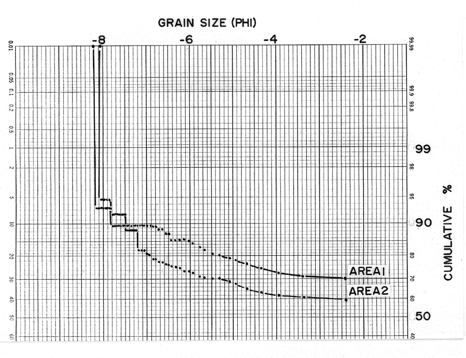
Diamictite matrix, the total area comprised of less-than-10 mm (-3.3 f) particles, ranged from approximately 50 to 70 percent, and measured clasts, the balance. Very rare boulders with bedding (-8.5 to -12.3 f) and matrix-coated boulders also occur at Albion, but are not part of our analyses. Cumulative grain-size (f) frequency curves, with probability ordinate, displaying Albion's grain sizes have consistent, distinctive shapes displaying slope breaks near -4 f and -7 f, which may signify a potentially complex origin for this unit (Petruny and King, 2000). Figure 4 shows two characteristic cumulative grain-size (f) frequency curves, with probability ordinate, from different meter-square areas at Albion Quarry. Area 1 (Figure 4) has matrix content equal to 67.6% and Area 2 (Figure 4) has 56.5%. Both show breaks at approximately -4 and -7 f, and have other irregularities in their distribution, which strongly suggests mixing of populations of grains and a strongly 'non-normal' distribution. The coarse tails of both size-frequency distributions are poorly defined due to low numbers of grains (i.e., many higher size 'bins' are empty).
Because such a high percent of matrix is involved in our measurements, and because we could not disaggregate the matrix for purposes of compatible detailed size-frequency analysis, we are limited as to the type of statistical analysis that can be performed upon these grain-size data. Specifically, we are unable to compute a mean grain-size value (sensu Folk (1968) and as defined in other standard sedimentology texts) owing to absence of data points within the fine tail. However, using a modified 'moment method' (modified from Folk, 1968), which allows comparisons of standard deviations within grain-size populations without computing a mean (i.e., where mean is unknown), we were able to compute an approximation of standard deviation (i.e., sf see Folk, 1968, p. 50) for comparative purposes.
Grain-size frequency curves from Areas 1 and 2 both yield sf values approximately equal to 4 f, indicating an "extremely poorly sorted" sediment (Folk, 1968). Combined with widely variable angularities and grain shapes and evident slope breaks in grain-size frequency curves, this additional quantitative measure of poor sorting suggests mixed populations of clasts from multiple sources.
DISCUSSION
We find no evidence that might contradict the well-founded interpretations of Ocampo et al. (1996; 2000) and Pope et al. (1999) regarding ejecta-related origin of Cretaceous-tertiary boundary strata in northern Belize. As our emphasis in this study was upon the diamictite unit, we offer the following conclusions regarding some of our specific observations.
Individual beds within the diamictite unit and their intrastratal bedding characteristics suggests to us that multiple events likely generated the five or more beds at Albion Island. As crude grading is present throughout most beds and laminar flow features characterize the upper reaches of most beds, we think that these units were sedimented within a substantially viscous fluid medium. Considering the presence of matrix-coated boulders and complex surficial markings on most clasts, we think that sedimentation conditions for each bed may have been initially turbulent, but near the end of emplacement they were more nearly laminar. This further implies a sequence of bed-placement events that would be requisite to development of Albion diamictite stratigraphy as at Albion Island.
Grain-shape analysis suggests that many diamictite clasts display shape characteristics derived directly from original sedimentary bedding. However, some clasts are highly abraded and perhaps transported over very significant distances. Diamictite clasts display surficial evidence of a sequence of events that may have been initially very violent and on the whole indicates intensive clast interaction. We think this suggests a mixing of clast populations having different transport histories and distances.
Comparison of Barton Creek facies at Albion Island and lithologies of diamictite clasts shows significant differences. For example, none of the cross-stratified, coarsely crystalline dolomitic packstone and grainstone, which is a common lithic type at Albion, is present in the overlying diamictite. Mainly for this reason, we think that the underlying Barton Creek at Albion Island was not the main source for Albion's diamictite clasts. We recognize that a local Albion source would seem to be the most likely explanation and is the previous interpretation of the Bunte Breccia from Ries crater, Germany, a widely cited analogue of the Albion formation (Horz et al., 1983). However, our interpretation is supported by work of Fouke et al. (1996) who showed that cathodoluminescent signatures of carbonate cements in Albion diamictite clasts were substantially different from those of bedrock samples taken from the Barton Creek at Albion Quarry.
Distinctive slope breaks within cumulative grain-size (f) frequency curves, with probability ordinate, and supporting statistical analysis that shows "extremely poor sorting" within the diamictite. Grain-size distribution at Albion is clearly not 'normal' and probably represents a mixing of several populations. We think this supports our contention that Albion diamictite clasts have a complex provenance.
CONCLUSIONS
Our observations on the stratigraphy and sedimentology of Cretaceous-Tertiary diamictite deposits of northern Belize lead us to conclude that multiple events delivered material of complex, impact-related origin to this region. These multiple events are likely related to stages in the collapse of Chicxulub's ejecta curtain and or interactions between that ejecta curtain and the atmosphere. More work is needed on the ground in Belize and in modeling ejecta-atmosphere interactions in order to understand the process-product relationship in more detail.
REFERENCES
Cornec J.H. (1985): Note on the provisional geological map of Belize at the scale 1:250,000. Petroleum Office, Belmopan, Belize. 22p.
Cornec J.H. (1986): Provisional geological map of Belize. Petroleum Office, Belmopan, Belize.
Folk R.L. (1968): Petrology of sedimentary rocks. Hemphill's Company, Austin, Texas.170p.
Fouke B.W., Alvarez W., Claeys P., Ocampo A.C., Pope K.O., Smit J., Vega F.J. (1996): Cathodoluminescence study of carbonate growth phases in bedrock and KT ejecta from the Chicxulub impact, Albion Island quarry, Belize. Geol. Soc. Amer. Abst. w. Prog., v. 28, no. 7, A183.
Fouke B.W., Zerkle A.L., Alvarez W., Pope K.O., Ocampo, A.C. (2000): Paleoenvironmental reconstruction of the KT impact event from proximal sedimentary ejecta, Albion Island, Belize. Geol. Soc. Amer. Abst. w. Prog., v. 32, no. 7, A451.
Horz F., Ostertag R., Rainey D.A. (1983): Bunte breccia of the Ries: continuous deposits of large impact craters. Rev. Geophys. Space Phys., v. 21, 1667-1725.
King, Jr. D.T. (1996b): Cretaceous-Tertiary boundary stratigraphy near San Antonio, OrangeWalk District, Belize, Central America. Gulf Coast Assoc. Geol. Soc. Trans., v. 46, 213-217. [reproduced above]
King, Jr. D.T. (1996a): Stratigraphy: layers of evidence (at Albion Island): Planetary Rept., v. 16, no. 3, 10-11. [reproduced above]
King, Jr. D.T., Petruny L.W. (2000): Astrostratigraphic units - some proposed nomenclature for terrestrial impact-derived and impact-related materials. Lunar Planet. Sci., v. 31, abst. no. 2019. [reproduced below]
King, Jr. D.T., Demick J.D., Pope K.O., Ocampo A.C. (1997): Surface markings on Chicxulub ejecta clasts from Belize, Central America. Geol. Soc. Amer. Abst. w. Prog., v. 29, no. 3, 12.
Ocampo A.C., Pope K.O., Fischer A.G. (1996): Ejecta blanket deposits of the Chicxulub crater from Albion Island, Belize. Geol. Soc. Amer. Spec. Paper, no. 307, 75-88.
Ocampo A.C., Pope K.O., Vega F., Fouke B.W. (2000): Depositional facies of the Chicxulub ejecta blanket in the southern Yucatan Peninsula. Eos, Trans. Amer. Geophys. Union, v. 81, no. 48, F798.
Petruny L.W., King, Jr. D.T. (2000): Grain-size frequency distributions of Cretaceous-Tertiary boundary breccia deposits in Belize, Central America. Geol. Soc. Amer. Abst. w. Prog., v. 32, no. 7, A451-452.
Pope K.O., Ocampo A.C., Fischer A.G., Alvarez W., Fouke B.W., Webster C.L., Vega F.J., Smit J., Fritsche A.E., Claeys P. (1999): Chicxulub impact ejecta from Albion Island, Belize. Earth Planet. Sci. Let., v. 170, 351-364.
Rampino, M.R., Ernston K., Fischer A.G., King, Jr. D.T., Ocampo A.C., Pope K.O. (1996): Characteristics of clasts in K/T debris-flow diamictites in Belize compared with other known proximal ejecta deposits: Geol. Soc. Amer. Abst. w. Prog., v. 28, no. 7, A-182.
Sharpton V.L., Marin L.E., Carney J.L., Lee S., Ryder G., Schuraytz B.C., Sikora P., Spudis P.D. (1996): The Cretaceous-Tertiary event and other catastrophies in Earth history. Geol. Soc. Amer. Spec. Paper, no. 307, 55-74.
Vega F.J., Feldman R.M., Ocampo A.C., Pope K.O. (1997): A new species of Late Cretaceous carcineretid crab (Brachyura: Carcineretidae) from Albion Island, Belize. Jour. Paleontol., v. 71, 615-620.
FIGURES
Figure 1. Location map showing the Yucatan peninsula of Mexico. Chicxulub crater rim and the study site at Albion Quarry (AQ) are indicated.
Click
here for larger version.
Figure 2. Correlation among five measured sections in Albion Quarry. Top of all sections is the ground surface. Datum is the Barton Creek-spheroid-bearing clay layer contact. Spacing between sections is indicated at bottom. Clasts are shown to relative scale; smallest clast shown (dot) is pebble size. Spheroid symbols indicate degree of flattening. Abbreviations: Cfl = crude flow lamination; Mcb = matrix-coated boulder; Bwb = boulder with bedding; RGcc = red and green clay clasts; Gpl = glide planes. Sections: AQ1 = loading road, north end, upper part; AQ2 = pit road, north end, east side; AQ3 = loading road, north end, lower part; AQ4 = pit road, south end, east side.
Click
here for larger version.
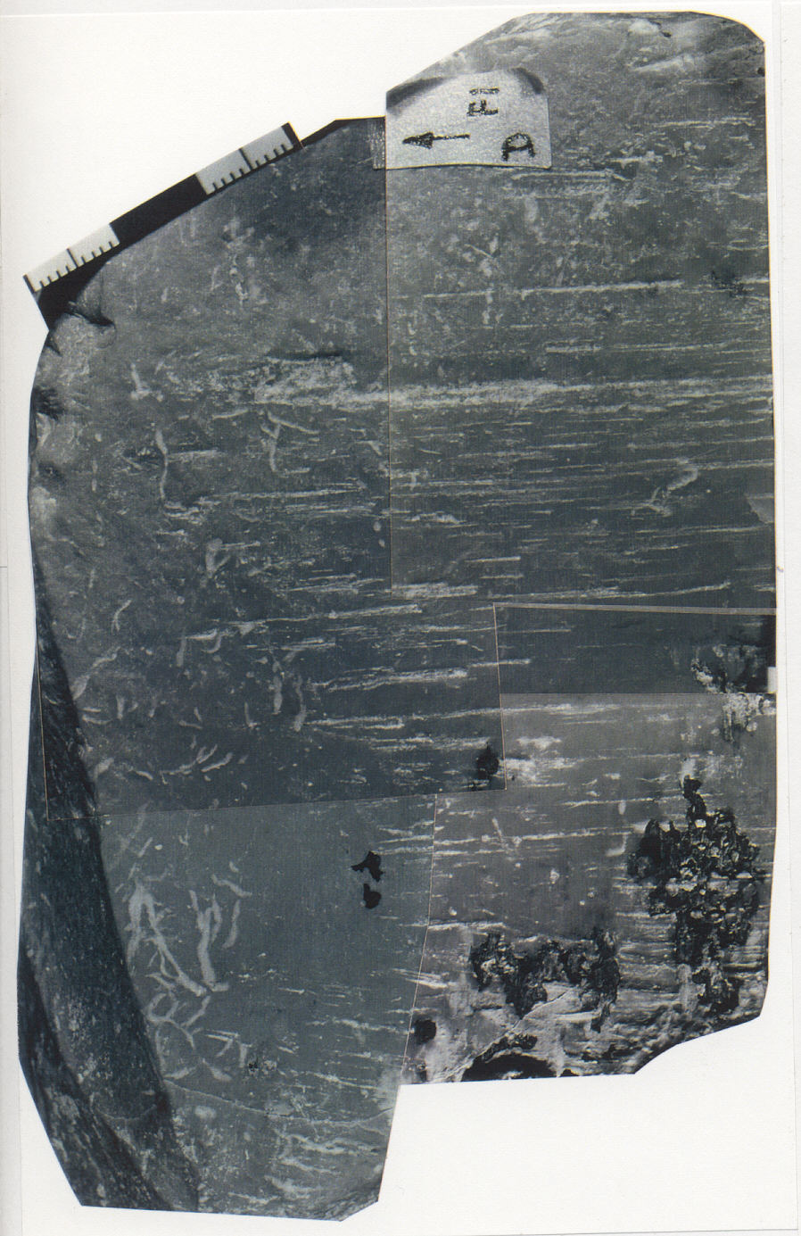
Figure 3. Typical clast surface from diamictite at Albion Quarry (upper image) and small-scale geological map of same clast surface (lower image). Mapping supports the general order of events: polish (first); striations; cryptographic markings; bruises and pits; and chips (last).
 Click
for larger version.
Click
for larger version.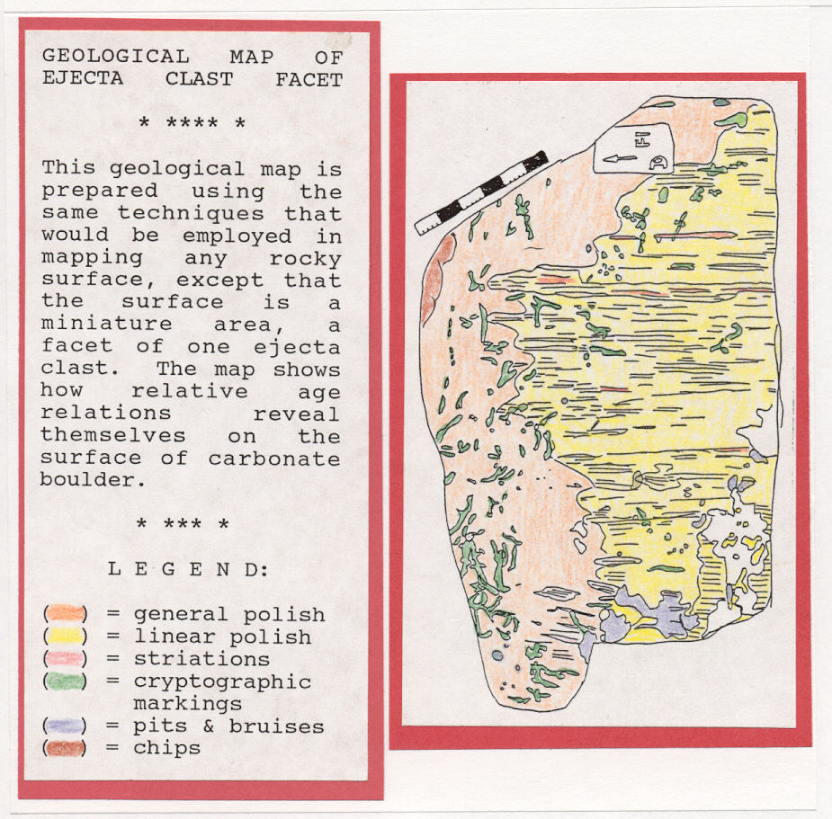 Click
for larger version.
Click
for larger version.
Figure 4. Cumulative grain-size (f) frequency curves, with probability ordinate, for Areas 1 and 2, Albion Quarry. Matrix smaller than -2.32 f (5 mm) was not measured in the field. Rare boulders larger than -8.23 f (300 mm) were not part of our analyses.
 Click
here for larger version.
Click
here for larger version.
* * * * * * * * * * *
* * * * * * * * * * * * * * * * * * * * * * * * * * * * * * * * * * * *
* * * * * * * * * * * * * * * * * * * * * * * * * * * * * * * * * * *
Astrostratigraphic Units - Some Proposed Nomenclature for Terrestrial Impact-derived and Impact-related Materials
D. T. King, Jr.
and
L. W. Petruny
Department of Geology, Auburn University,
Auburn, AL 36849-5305 USA
Department of Curriculum and Teaching,
Auburn
University, Auburn, AL 36849-5305 USA
[This paper is modified from one originally published by the authors in Lunar and Planetary Sciences, v. 31 (2000), abstract no. 2019.]
Introduction: The two most influential sources on general stratigraphic nomenclature, principles, and procedure, the North American Commission on Stratigraphic Nomenclature (NACSN) and the IUGS-International Subcommission on Stratigraphic Classification (ISSC), do not specifically address stratigraphic classification of impact-derived materials and related issues in their respective treatises [1,2]. However, NACSN and ISSC systematics probably could be expanded into this area. Petrologic classification and nomenclature of impact-derived materials (i.e., impactites) has been organized by a study group of the IUGS-Subcommission on Systematics of Metamorphic Rocks [3,4], but a potentially desirable holistic stratigraphic perspective is not taken into account therein. Existing NACSN and ISSC stratigraphic classifications seem better suited to accommodation of Earth's gradualistic geological record, and there is probable need for a separate scheme of formal and (or) informal stratigraphic nomenclature of all various impact-derived and impact-related materials and their aspects at all scales.
The following are some examples of ambiguities and problems with classification of impact-derived materials regarding present schemes of nomenclature. Intra-crater authigenic (monomict) and allogenic (polymict) deposits do not consistently conform to Steno's law, and thus may have either or both a lithodemic [see 1] and a lithostratigraphic character (within one locale or in different locales). Extra-crater deposits are much like lithostratigraphic or allostratigraphic units [see 1], but as event deposits, also have a strong lithochronostratigraphic aspect [see 1, 2]. Proximal authigenic and allogenic deposits (i.e., deposits of continuous ejecta) may be mappable as either formations, beds, lenses, tongues, alloformations, or lithochronozones [see 1]. In contrast, distal impactoclastic air-fall deposits are more properly viewed as fine-scale lithochronostratigraphic zones or lithostratigraphic horizons [see 2], useful not on maps, but in correlation. Further, many distal impactoclastic deposits have a biostratigraphic aspect (i.e., they are related to or include biostratigraphic units), and some distal impactoclastic deposits manifest themselves as horizons distinguished only as a level with sparsely distributed impact-generated constituents or as a geochemical anomaly. Owing to their fine scale and potentially diffusive nature, distal impactites are particularly vulnerable to obliteration (i.e., sedimentary amalgamation) and other effects such as stratigraphic leakage and remanie [5]. Thus, distal impactities pose peculiar problems of detection. Finally, all impact-derived and related materials attributable to a single impact event should be viewed as a highly disparate, impact-generated chronostratigraphic entity, which includes impact-related materials such as tsunamites, seismites, and other possible products of impact-related processes. Currently available nomenclature has yet to encompass this ontology.
Astrostratigraphic units: To designate units produced by or related to terrestrial impact events, we propose the term 'Astrostratigraphic' unit. Astrostratigraphic units are intended to be more nearly like genetic 'geologic units' used in planetary mapping schemes (sensu Wilhelms [6]), than currently defined lithostratigraphic, lithodemic, or chronostratigraphic units. Such 'geologic units' of planetary mapping have been defined as "discrete three-dimensional bodies of rock formed, relative to those neighboring units, (a) by a discrete process or related processes, and (b) in a discrete timespan" [6]. Thus, astrostratigraphic units are hybrid units that encompass some lithostratigraphic, lithodemic, and chronostratigraphic concepts, but are not entirely objective units.
Astrostratigraphic units are bodies of rock and (or) sediment unified by their specific relationship to a terrestrial impact event or closely related terrestrial impact events. Astrostratigraphic units are distinguished from surrounding rock units by their genetic relationship to such events. Astrostratigraphic units have boundaries that may be of a physical, paleontological, or structural nature, and are commonly distinctive discontinuities.
Astrostratigraphy includes: proximal (intra-crater) and distal (extra-crater) impactite units; impactoclastic horizons, deposits, and regoliths; impact-glass horizons (or strewn levels); melt and breccia dikes of impact origin; pseudotachylites; tsunamites and seismites of impact-related origin; other impact-related units, and impacto-correlative units. The latter term, impacto-correlative unit, is intended to apply to rock and (or) sediment that is coeval with impact-derived and related material, but does not necessarily contain a significant component of impact-derived or related materials. Proximal (intra-crater) units may include impact olistostromes (slide accumulations [7]), impact wildflysch (impact melanges [7], impact broken formations [7], impact dismembered formations [7], and impact lithodemes [1].
Astrostratigraphic units are intended to be mappable at the Earth's surface and (or) correlative in stratigraphic cross-section. Astrostratigraphic units should have a proper name that is the same as or derives directly from the related impact structure or structures (e.g., Chicxulub Impact Formation or Chesapeake Impact Horizon).
Hierarchy of units: The fundamental Astrostratigraphic unit is Impact Formation [see also 3,4]. Impact formations may be of two distinct kinds, authigenic and allogenic, or may be heterogenous (mixed kinds). Authigenic Impact Formations include Impact Melanges. The former is defined as an impact-generated or related "body of rock ... characterized both by the lack of internal continuity of bedding contacts or strata and by the inclusion of fragments and blocks of all sizes ... embedded in a fragmented matrix of finer-grained material" [7].
A set of Impact Formations is an Impact Group, a major subdivision of an Impact Formation is an Impact Member, and a minor subdivision, an Impact Bed. Astrostratigraphic units with lithodemic characteristics [see 1] may be called Impact Complex, or specific names like Impact Dike or Impact Melange may be used as appropriate. The foregoing units should have their most practical value in work with intra-crater and proximal extra-crater units.
Distal impactoclastic units are Impact Formations, if such units are sufficiently thick to be mappable at a useful scale. Impact Formations may contain Impact Members and Beds. Other, fine-scale distal impactoclastic units are Impact Horizons, which are typically related to air-fall origin.
References: [1] N. Amer. Comm. Strat. Nomencl. (1983) Amer. Assoc.
Petrol. Geol., 67, 841-875. [2] Salvador A. (1994) Int'l. Strat.
Guide 2d. ed., 214p. [3] Stoffler D., Grieve R.A.F. (1994) Lunar
Planet. Sci. XXV, 1347-1348. [4] Stoffler D., Grieve R.A.F. (1994)
ESF Sci. Net. Impact Cratering Newsl., 17-27. [5] Huber H.
et al. (2001)
Lect. Notes Earth Sci., in press. [6]
Wilhelms D.H. (1990) Planetary Mapping, 208-260. [7] Raymond L.A.
(1984) Geol. Soc. Amer. Spec. Paper 198, 7-20.
* * * * * * * * * * *
* * * * * * * * * * * * * * * * * * * * * * * * * * * * * * * * * * * *
* * * * * * * * * * * * * * * * * * * * * * * * * * * * * * * * * * *
Return to David T. King, Jr.'s HOMEPAGE!
 Click
here for larger version.
Click
here for larger version.
 Click
here for larger version.
Click
here for larger version.
Click
here for larger version.
Click here
for larger version.
Click
here for larger version.
Click
here for larger version.
Pooks pebble showing fusion crust, fine
polish, and impact crater.
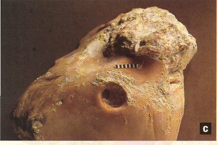
Photograph by A.C. Ocampo and K.O. Pope.
From Planetary Report, v. 16, p. 9. (c) Planetary Society.
